Tellicherry Fort

Last updated

Tellicherry Fort
Thalassery fort.JPG
Location Thalassery taluk, Kerala, India
Coordinates 11°44′54″N75°29′10″E / 11.748292°N 75.486134°E / 11.748292; 75.486134
India Kerala location map.svg
Red pog.svg
Location in Kerala, India
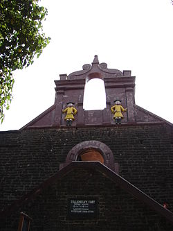
Tellicherry Fort is located in Thalassery (Tellicherry), a town in Kannur District of Kerala state, South India. Thalassery was one of the most important European trading centers in Kerala. The Fort lies on a group of low wooden hills running down to the sea and is protected by natural waters. It has been the main outlet for the rich spices, hill products, and timber of the vast hinterland.

Contents

The French were the first to engage in trading at Tellicherry, establishing a stronghold at Mahé, Puducherry, 5 km south of Tellicherry town. Toward the end of the 17th century, the British opened a factory north of Tellicherry. Later, they obtained a site from Vadakkelamkur, the de facto ruler of Kolathunad, and established a factory at Tellicherry in 1708. However, the Udayamangalam branch of the Kolathiri family and Korangoth Nair, the local chieftain, resented this action and launched an attack, causing serious damage to English property. In order to safeguard their trade activities, with the support of the Kolathiri Raja, they built a fort around the outlying hills of Tellicherry. The French occupation of Mahé in 1725 compelled the British Company to strengthen the fortification to establish a stronghold on the Malabar Coast. In 1736, the British took possession of Dharmadam Island. They maintained a strong military establishment at Tellicherry from 1776 to 1784.

In 1781, Hyder Ali, ruler of the Kingdom of Mysore, unsuccessfully attempted to capture the Fort during his campaign to control Malabar. His successor, Tipu Sultan, was forced to cede the Malabar District to the British in 1792, at the conclusion of the Third Anglo-Maratha War.

The Tellicherry fort, overlooking the sea, rises to a height of 10m and is oblong in plan. It was built out of laterite blocks with high round-holed walls and strong flanking bastions. Although the small redoubts on most of the outlying hills have long since disappeared, the Tellicherry fort is in a fair state of preservation. The square fort, with its massive walls, strong flanking bastions, secret tunnels to the sea, and intricately carved huge doors, is an imposing structure. A lighthouse marks the site of an old redoubt. The fort was once the nucleus of Thalassery's development. Tellicherry was also famous for the cricket matches played between Europeans and local teams near the seashore, which used to attract enormous crowds during those days. This is a centrally protected monument under the control of the Archaeological Survey of India since 1921. [1] [2]

See also

Description01.jpg

Related Research Articles

<span class="mw-page-title-main">Bekal Fort</span> Place in Kerala, India

Bekal Fort is a medieval fort built by Shivappa Nayaka of Keladi in 1650 AD, at Bekal. It is the largest fort in Kerala, spreading over 40 acres (160,000 m2).

<span class="mw-page-title-main">Kannur district</span> District in Kerala, India

Kannur is one of the 14 districts along the west coast in the state of Kerala, India. The city of Kannur is the district headquarters and gives the district its name. The old name, Cannanore, is the anglicized form of the Malayalam name "Kannur". Kannur district is bounded by Kasaragod District to the north, Kozhikode district to the south, Mahé district to the southwest and Wayanad District to the southeast. To the east, the district is bounded by the Western Ghats, which forms the border with the state of Karnataka. The Arabian Sea lies to the west. Paithalmala is the highest point in Kannur District (1,372m). Enclosed within the southern part of the district is the Mahé district of the Union Territory of Puducherry. The district was established in 1957.

<span class="mw-page-title-main">Thalassery</span> City in Kerala, India

Thalassery, formerly Tellicherry, is a municipality and commercial city on the Malabar Coast in Kannur district in the state of Kerala, India, bordered by the districts of Mahe, Kozhikode, Wayanad, Kasaragod and Kodagu (Karnataka). Thalassery municipality has a population of just under 100,000 as of 2011 census. Thalassery Heritage City has an area of 23.98 square kilometres (9.26 sq mi). Thalassery has an altitude ranging from 2.5 to 30 metres above mean sea-level.

<span class="mw-page-title-main">Vatakara</span> Municipality in Kerala, India

Vatakara,, , French: Bargaret, is a Municipality, Taluk and a major town in the Kozhikode district of Kerala state, India. The municipality of Vatakara covers an area of 23.33 km2 (9.01 sq mi) and is bordered by Mahé to the north and Payyoli to the south. It is the headquarters of Vatakara taluk, which consists of 22 panchayats. During the reign of the Kolathiris and Zamorins, Vatakara was known as Kadathanadu. During the British Raj, it was part of the North Malabar region of Malabar District in the state of Madras. The historic Lokanarkavu temple, made famous by the Vadakkan Pattukal, is situated in Vatakara. A new tardigrade species collected from Vadakara coast has been named after Kerala State; Stygarctus keralensis.

<span class="mw-page-title-main">Kannur</span> City in India

Kannur, formerly known in English as Cannanore, is a city and a municipal corporation in the state of Kerala, India. It is the administrative headquarters of the Kannur district and situated 274 kilometres (170 mi) north of the major port city and commercial hub Kochi and 137 kilometres (85 mi) south of the major port city and a commercial hub, Mangalore. During the period of British colonial rule in India, when Kannur was a part of the Malabar District, the city was known as Cannanore. Kannur is the sixth largest urban agglomeration in Kerala. As of 2011 census, Kannur Municipal Corporation, the local body which administers mainland area of city, had a population of 232,486.

<span class="mw-page-title-main">Kolathunadu</span> Kingdoms on the Malabar Coast in India

Kolattunādu (Kola Swarupam, as Kingdom of Cannanore in foreign accounts, Chirakkal (Chericul) in later times) was one of the four most powerful kingdoms on the Malabar Coast during the arrival of the Portuguese Armadas in India, along with Zamorin, the Kingdom of Cochin and Quilon. Kolattunādu had its capital at Ezhimala and was ruled by the Kolattiri royal family and roughly comprised the North Malabar region of Kerala state in India. Traditionally, Kolattunādu is described as the land lying between the Chandragiri river in the north and the Korappuzha river in the south. The Kolathunadu (Kannur) Kingdom at the peak of its power, reportedly extended from the Netravati River (Mangalore) in the north to Korapuzha (Kozhikode) in the south with the Arabian Sea on the west and Kodagu hills on the eastern boundary, also including the isolated islands of Lakshadweep in the Arabian Sea.

<span class="mw-page-title-main">Malabar District</span> Administrative district of Bombay and later Madras from 1792 to 1956

Malabar District, also known as Malayalam District, was an administrative district on the southwestern Malabar Coast of Bombay Presidency (1792–1800), Madras Presidency (1800–1937), Madras Province (1937–1950) and finally, Madras State (1950–1956) in India. It was the most populous and the third-largest district in the erstwhile Madras State. The historic town of Calicut was the admisnitrative headquarters of this district.

Nelliyalam is a panchayat town in The Nilgiris district in the Indian state of Tamil Nadu. As of 2011, the town had a population of 44,590.

Pandalur is a small town near Gudalur in the Pandalur taluk of Nilgiris district in Tamil Nadu, India.

<span class="mw-page-title-main">Devala, India</span> Village in Tamil Nadu, India

Devala is a town in the Nilgiris district of Tamil Nadu. It is situated at about 17 km from Gudalur on the Gudalur–Pandalur road. It is close to the Kerala-Tamil Nadu border, with Nilambur on the Kerala side.

<span class="mw-page-title-main">North Malabar</span> Geographical / Historical Area in India

North Malabar refers to the geographic area of southwest India covering the state of Kerala's present day Kasaragod, Kannur, and Wayanad districts, and the taluks of Vatakara and Koyilandy in the Kozhikode District of Kerala and the entire Mahé Sub-Division of the Union Territory of Puducherry. Traditionally North Malabar has been defined as the northern portion of the erstwhile Malabar District which lies between Chandragiri River and Korapuzha River. The region between Netravathi River and Chandragiri River, which included the portions between Mangalore and Kasaragod, are also often included in the term North Malabar, as the Kumbla dynasty in the southernmost region of Tulu Nadu, had a mixed lineage of Malayali Nairs and Tuluva Brahmins.

Gudalur taluk is a taluk of Nilgiris district of the Indian state of Tamil Nadu. The headquarters of the taluk is the town of Gudalur.

Kundah taluk is a taluk of Nilgiris district of the Indian state of Tamil Nadu. The headquarters of the taluk is the town of Kundah and consists of seven revenue villages. Being Balacola, Kil Kundah, Mulligoor, Bikkatty, Kinnakorai, Ithalar and Mel Kundah.

The Siege of Tellicherry was a military embargo that happened in Thalassery. The Commander in Chief of the Mysore Calicut Province, Sirdar Ali, took siege of the British Military Barrack of Thalassery for 18 months. They British and the local administrators were blockaded within Thalassery by land as well as by sea. It was during the Second Anglo-Mysore War. The siege continued until reinforcements from Bombay under the command of Major Abington attacked the Mysore army and defeated them. Major Abington then moved south, capturing Calicut. The Siege of Tellicherry led to the fall of strongholds of the First Mysore conquest, led by Hyder Ali. Even though laterTipu Sultan came from Mysore to reinstate the conquered area to previous status.

<span class="mw-page-title-main">Mysorean invasion of Malabar</span>

The Mysorean invasion of Malabar (1766–1792) was the military invasion of the Malabar region of Kerala, including the territories of the Zamorin of Calicut, by the then-de facto ruler of the Kingdom of Mysore, Hyder Ali. After the invasion, the Kingdom of Cochin to the south of Malabar became a tributary state of Mysore.

<span class="mw-page-title-main">Arakkal kingdom</span> Erstwhile Muslim Monarchy in North Kerala

Arakkal Kingdom was a Muslim kingdom in Kannur town in Kannur district, in the state of Kerala, South India. The king was called Ali Raja and the ruling queen was called Arakkal Beevi. Arakkal kingdom included little more than the Cannanore town and the southern Laccadive Islands, originally leased from the Kolattiri. They owed allegiance to the Kolattiri rulers, whose ministers they had been at one time. The rulers followed the Marumakkathayam system of matrilineal inheritance, a system that is unique to a section of Hindus of Kerala. Under Marumakkathayam, the succession passes to the male offspring of its female members, in other words from a man to his sister's son and so forth. As the only Muslim rulers in Malabar, they saw the rise of Hyder Ali, de facto ruler of the Mysore Sultanate as the opportunity to increase their own power at the expense of Chirakkal, and invited him to invade Kerala. Ali Raja Arakkal Sultan Afsal Ashraf living in Konni Panchayat of Pathanamthitta district is the living heir of the Arakkal dynasty.

<span class="mw-page-title-main">History of Kannur</span>

Kannur, formerly known in English as Cannanore, Arabic as Kannanur, and Portuguese as Cananor, is a city and a Municipal Corporation in North Malabar region, state of Kerala, India. It is the largest city in North Malabar, which is the northernmost region of Kerala. It is sometimes identified Kolathunadu, which was ruled by the Kolathiris. In the 12th and 13th centuries there was trade with Persia and Arabia.

Kannur, India has a number of tourist attractions including beaches, hills, temples and other monuments.

Thalassery was a trade hub where Chinese, Arab, and Jewish traders had considerable influence in the spice market before that the Greeks and Romans was in the trade. It was the European invasion that brought significant change as they enforced the trade with their military.

The Thalassery carnival, the Beach fest in Muzhappilangad beach and Dharmadam beach are notable attractions. The area's four rivers around Thalassery town and four beaches with more in Kannur also attract visitors.

References

  1. "Kannur Tourism - Places - Thalassery Fort".
  2. "Thalassery Fort, Thalassery".

11°44′54″N75°29′10″E / 11.748292°N 75.486134°E / 11.748292; 75.486134