Ashtamudi Lake | |
---|---|
അഷ്ടമുടി കായൽ (Malayalam) | |
Location | Kollam District, Kerala |
Coordinates | 8°59′N76°36′E / 8.983°N 76.600°E |
Primary inflows | Kallada River |
Catchment area | 1,700 km2 (660 sq mi) |
Basin countries | India |
Surface area | 61.4 km2 (23.7 sq mi) |
Max. depth | 6.4 m (21 ft) |
Water volume | 76,000,000,000 km3 (1.8×10¹⁰ cu mi) |
Surface elevation | 10 m (33 ft) |
Islands | Sambrani Island,Prakkulam Munroe Island Chavara Thekkumbhagom |
Settlements | Kollam (Metropolitan Area) Kundara (Census Town) |
Designated | 19 August 2002 |
Ashtamudi Lake (Ashtamudi Kayal), in the Kollam District of the Indian state of Kerala. It possesses a unique wetland ecosystem and a large palm-shaped (also described as octopus-shaped) water body, second only in size to the Vembanad estuary ecosystem of the state. Ashtamudi means 'eight braids' (Ashta : 'eight'; mudi : 'hair braids') in the local Malayalam language. The name is indicative of the lake's topography with its multiple branches. The lake is also called the gateway to the backwaters of Kerala and is well known for its houseboat and backwater resorts. [1] [2] [3] Ashtamudi Wetland was included in the list of wetlands of international importance, as defined by the Ramsar Convention for the conservation and sustainable utilization of wetlands. [4]
Along both banks of the lake and its backwater canals, coconut groves and palm trees interspersed with towns and villages are seen. Kollam, (formerly Quilon) is an important historic port city located on the right bank of the lake. Boat cruises are operated by the Kollam Boat Club from Kollam to Alappuzha providing transport access to many other towns and villages along this route. Luxury houseboats also operate on the lake. The boat journey is an 8-hour trip, winding through lakes, canals and water bound villages.[ citation needed ] Chinese fishing nets, called cheena vala in Malayalam, are used by local fisherman and are a common sight along the waterway. [1] [5] [6]
The lake and the city of Kollam on its banks and the Neendakara port at the confluence offer a means of transport for the state's trade and commerce in the cashew trading and processing industry as well as the marine products industry. [6]
The lake is the source of livelihood of many people living close by. Fishing, coconut husk retting for coir production and inland navigation services are the prominent businesses.
In 2014, the Clam Governing Council of Ashtamudi lake became the first Marine Stewardship Council certified fishery in India for their sustainable clam fishing. [7]
The lake and the life on its shores have inspired many artists and writers. It has been the subject of many poems by the renowned poet Thirunalloor Karunakaran who was born and brought up on its banks.
Quilon or Kollam and inevitably Ashtamudi lake's importance is claimed to be dated to the days of the Romans and the Phoenicians. Ibn Batuta, during his 24-year sojourn in the 14th century, is reported to have mentioned about the Quilon port as one of the five ports for Chinese trade. Links with Persia (9th century), Chinese mandarin in 1275 AD, Portuguese in 1502 AD, and the Dutch followed British in 1795 AD are recorded history. Velu Thampi is credited with organizing the rebellion against the British from this place. [8]
Considering Kollam as the entry city to the lake, access to the lake are to the Thiruvananthapuram International Airport, 71 km (44 mi) away and by road to almost all important centres in Kerala and the rest of the country. National Highway 47 (NH 47) passes through the lake periphery not only from Quilon but also to other locations on its bank from Thiruvananthapuram to the northern towns of Kerala. Southern Railways network of lines connects Quilon with all important centres in the rest of the country. Ferry services operate daily to Alleppey and boats operate to all villages located in the canals of the backwater system. The boat jetty is located at about 2 km (1.2 mi) away from the railway station. [6] Famous Paravur estuary and backwaters are just 21 kilometer away from Ashtamudi.
Kallada River is a major river discharging into the Ashtamudi Lake. The Kallada river, which originates near Ponmudi from the Kulathupuzha hills Western Ghats is formed by the confluence of three rivers, viz., Kulathupuzha, Chenthurnipuzha, and Kalthuruthipuzha, and after traversing a distance of about 121 km (75 mi) through virgin forests finally debouches into the Ashtamudi wetland at Peringalam near Kollam. With a maximum depth of 21 ft (6.4 m) at the confluence, it is Kerala's deepest estuary. [9] [10]
Quaternary and Tertiary sediments and sedimentary rocks are the formations in the lake basin and environs. The Quaternary sediments are of marine and fluvial alluvium of recent age. Tertiary sediments comprise laterite, sandstones and clays of Warkalai formation. [3]
The average annual runoff from the river system into the estuary is reported to be 76 cubic kilometers of freshwater. [10] The basin drainage area is 1,700 km2 (660 mi2) and with an average annual rainfall of 2400 mm (94 in) it discharges 3.375 km3 (2,740,000 ac·ft) of flow annually. It acts as a flood storage lake thus protecting the thickly populated city of Quilon (Kollam) and the coastal land. The Kallada dam built across the Kallada river is 85.3 m high by 35 m long (280 ft by 115 ft) with a reservoir area of 23 km2 (8.9 mi2) with a storage volume of 0.505 km3 (409,000 ac·ft). Though it provides irrigation to 61630 ha for paddy and upland crops, it has aggravated the salinity ingress into the wetland and the river due to reduced outflows during summer months. [3]
Temperatures recorded in the area are a maximum of 27.5 °C (81.5 °F) and a minimum of 25.5 °C (77.9 °F)[ dubious ]. The climate is hot and humid during April–May while cool during December–January.
Ashtamudi Estuary has mangroves Avicennia officinalis, Brugiera gymnorrhiza and Sonneratia caseolaris as also 43 species of marshy and mangrove associates including two endangered species Syzygium travancoricum (endangered species according to the Red Data Book of Indian Plants) and Calamus rotang in the Terrestrial system. [2] These species offer excellent scope for development of marine bioreserve to promote eco-tourism in the estuarine of the lake. [10] IUCN lists the two endangered species in IUCN 2008. The total number of Syzygium travancoricum is reported to be very small, not more than 200. The major threats to the endangered species are reportedly draining of the wet lands and conversion into paddy fields. [11]
The lake supports 57 species of avifauna, of which 6 are migratory and 51 resident species. [2] It is also reported that about 40 species of wetland-dependent birds are recorded in the lake, out of which 45% are long-distance migrants. Terns, plovers, cormorants, and herons are most abundant birds in the lake. [3] A study report has identified 45 insect species, including 26 species of butterfly, 5 odonates, 9 hymenopteras, and 2 orthopterans, 1 hemipteran and 2 coleopterans. About 29 zooplankton species have also been identified. [3] The water body is found to have 9 phytoplanktons such as Amphora, Borosigma, Cyclotella, Cymbella, Gyrozigma, Meloziva, Navicula and Nitzschi. [3]
World Wildlife Fund (WWF) reports[ citation needed ]
97 species of fish (42 are typically marine, 3 estuarine, 9 estuarine-riverine, 15 marine-estuarine) and unique copepod species. It is also a congenial habitat for all species of penaeid and palaemonid Prawns, edible crabs, paphia malabarica (short neck Clams) and a variety of fish. A comparative shell morphology study of short-neck clam Paphia malabarica, the main clam fishery resources in the Ashtamudi Lake re-assigned to the genus Marcia recens (Venus Clams) and this study found it was wrongly identified as short-neck clam in previous studies. [12] Clams found in the estuary are exported. [2] The estuary is the source of livelihood for thousands of fishermen and is stated to be the second biggest fish-landing centre after the Vembanad estuary. [10]
Munroe Island (Munroethuruth) is a cluster of eight tiny islands in Ashtamudi Lake.
Chavara South, a small village, an island within the Ashtamudi Lake, located 14 km (8.7 mi) away from Quilon on the National Highway NH 47, is reported to be mineral rich with number of factories for extraction and export of titanium and other minerals. Effluent from the factories is reported to be causing pollution of the lake waters. [13]
Thekkumbhagom island, situated on the bank of the Ashtamudi Lake, provides the feel of rustic life of a village.[ tone ][ citation needed ] The significance of this village is because the first epic poetry in the Malayalam language, Ramachandravilasam, was composed by the poet Azhakath Padmanabha Kurup in this village. An ancient 1000-year-old temple and a 200-year-old church are located here. [1]
An evaluation of the marketed use benefits of Ashtamudi estuary (valued using market valuation approach) has assessed the total direct use value at Rs.66.8 million per annum; coconut husk retting accounts for Rs.5.1 million, Inland navigation service accounts for Rs.3.7 million and the recreation benefit is assessed at Rs.1.5 million (using the standard travel cost method). But this is reported to be showing a downward trend, particularly in fish resources in the estuary. This evaluation provides an insight into the economic importance of conserving Ashtamudi estuary. [14]
The following are reported to be the reasons for deterioration of the lake environment: [2] [10]
Kanjiracode creek on the south-east end of the lake, one arm of the Ashtamudi, has suffered extinction due to the dumping of waste earth and clay into the lake by the Kerala Ceramics Limited (KCL) at Kundara, a state government-owned public sector unit. A university professor who has studied this aspect wonders[ citation needed ]
whether the lake would have to be soon rechristened "Sapthamudi" or the lake with seven locks of hair.
The loss to people due to destruction of the creek is stated to be: [10]
a) "Karimeen" (pearl spot) and "kanambu" (mullet) fish varieties once the livelihood of fishermen have disappeared and resulting in the migration of the fishermen to Paravur and Varkala in the south and even Kannur in the north.
b) People dependent on coir for a livelihood used the lake to soak husks but now the Kanjiracode coir industry is non-existent due to closure of the creek resulting in migration of coir workers to other places for a living.
The Asia Development Assistance Facility of the New Zealand Government has carried out a study with the objective of evolving a management plan for sustainable management of the estuary for ecosystem development. The shores of the lake are home to important species of rare birds and animals. Any decisions made concerning the Ashtamudi Estuary's resources and its sustainable management significance is dictated by about a million people who live on its shores and the large species of rare birds and animals which provide the equally important biodiversity to the lake's environs. [10] The Plan envisages: [15]
The above activities have been suggested for implementation in the Vellimon Kayal, a relatively unspoiled part of the estuary.
With funds provided by the Union Ministry of Environment and Forests, revival of mangrove forests was done which is reported to be partially successful (out of 2,40,000 mangrove saplings planted over a period of two years 30,000 are reported to be surviving). [10]
Kollam, also known by its former name Quilon, is an ancient seaport and city on the Malabar Coast of India bordering the Laccadive Sea, which is a part of the Arabian Sea. It is 71 km (44 mi) north of the state capital Thiruvananthapuram. The city is on the banks of Ashtamudi Lake and the Kallada river. Kollam is the fourth largest city in Kerala and is known for cashew processing and coir manufacturing. It is the southern gateway to the Backwaters of Kerala and is a prominent tourist destination. Kollam is one of the most historic cities with continuous settlements in India. Geographically, Quilon formation seen around coastal cliffs of Ashtamudi Lake, represent sediments laid down in the Kerala basin that existed during Mio-Pliocene times.
The Kerala backwaters are a network of brackish lagoons and canals lying parallel to the Arabian Sea of the Malabar coast of Kerala state in south-western India. It also includes interconnected lakes, rivers, and inlets, a labyrinthine system formed by more than 900 km (560 mi) of waterways, and sometimes compared to bayous. The network includes five large lakes linked by canals, both man made and natural, fed by 38 rivers, and extending virtually half the length of Kerala state. The backwaters were formed by the action of waves and shore currents creating low barrier islands across the mouths of the many rivers flowing down from the Western Ghats range. In the midst of this landscape there are a number of towns and cities, which serve as the starting and end points of backwater cruises. There are 34 backwaters in Kerala. Out of it, 27 are located either closer to Arabian Sea or parallel to the sea. The remaining 7 are inland navigation routes.
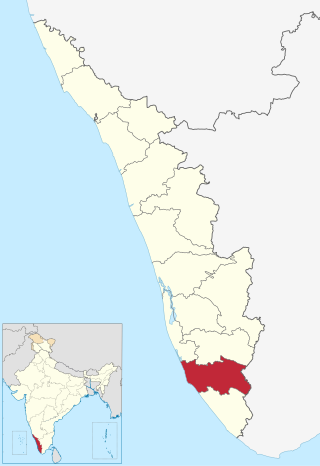
Kollam district, is one of 14 districts of the state of Kerala, India. The district has a cross-section of Kerala's natural attributes; it is endowed with a long coastline, a major Laccadive Sea seaport and an inland lake. The district has many water bodies. Kallada River is one among them, and land on the east bank of the river is East Kallada and that on the west bank is West Kallada.
Munroe Island or Mundrothuruthu is an inland island group located at the confluence of Ashtamudi Lake and the Kallada River, in Kollam district, Kerala, South India. It is a group of eight small islets comprising a total area of about 13.4 km2. The island, accessible by road, rail and inland water navigation, is about 25 kilometres (16 mi) from Kollam by road, 38 kilometres (24 mi) north from Paravur, 12 kilometres (7.5 mi) west from Kundara and about 25 kilometres (16 mi) from Karunagapally. As of the 2011 Indian census, the administrative village of Mundrothuruth has a total population of 9599, consisting of 4636 males and 4963 females. This island is also known as "Sinking Island of Kerala"
Chavara is a village in Karunagappally taluk, Kollam district, Kerala, India. It is a part of Kollam Lok Sabha constituency. The current MLA of the Chavara constituency is Dr. Sujith Vijayan Pillai of the LDF.
Paravur Kayal is a lake in Paravur, Kollam district, Kerala, India. Although it is small, with an area of only 6.62 km², it is the end point of the Ithikkara River and part of the system of lakes and canals that make up the Kerala Backwaters. It has been connected to Edava and Ashtamudi Kayal as part of the Trivandrum - Shoranur canal system since the late 19th century.
Sasthamcotta Lake or Sasthamkotta Lake, also categorized as a wetland, is the largest fresh water lake in Kerala, a state of India on the south of the West Coast. The lake is named after the ancient Sastha temple located on its bank. It meets the drinking water needs of half million people of the Quilon district and also provides fishing resources. The purity of the lake water for drinking use is attributed to the presence of large population of larva called cavaborus that consumes bacteria in the lake water. The lake is a designated wetland of international importance under the Ramsar Convention since November 2002.
The President's Trophy Boat Race is a popular boat race held on the Ashtamudi lake in Kollam city on 1 November every year. The day marks the birth of the Indian state of Kerala, known as Kerala Piravi. This is the most popular of the races to be held during the season of the harvest festival, Onam, in Autumn on Ashtamudi Lake in Kollam. There would be races in five categories, namely Chundan Vallam (snake-boats), two grades of Veppu Vallam, and two grades of Iruttukuthi Vallam. Sixteen snake-boats would compete in four heats. The trophy had been instituted in the name of the President of India. President of India will be present to witness the race and would also give away the trophy and cash prize to the winning team. The race will become a part of Kerala's IPL-model boat race league from 2019 onward. The Government of Kerala is planning to make President's Trophy Boat Race as the finishing event of Champions’ Boat League.
Sakthikulangara is a zone and neighbourhood situated at the coastal area of the city of Kollam in Kerala India. It is one among the 6 zonal headquarters of Kollam Municipal Corporation.
Kayamkulam Kayal, Kayamkulam Lake or Kayamkulam Estuary is a shallow brackish water lagoon stretching between Panmana and Karthikapally. It has an outlet to the Arabian sea at Kayamkulam barrage. The Kayal used to be connected to the sea most of the time except during dry season when a bar like formation separates it from the sea. Now the bar has been opened up permanently for construction of Kayamkulam Fishing Harbor. Kayamkulam boat race is conducted in Kayamkulam Kayal.
Thekkumbhagam or Thekkumbhagom is the southern border town of Paravur municipality in the Kollam district of Kerala, India. It is located at the Southern tip of Kollam's coastal area. It is in the Arabian Sea coast. Thekkumbhagam-Kappil estuary point in the Kollam-Thiruvananthapuram coastal border is one of the emerging tourism spots in the state. On 1936, during formation, Thekkumbhagam was one of the nine territories of Paravur Panchayath. Thekkumbhagam estuary is one among the twin estuary points in Paravur. The other one is Pozhikara estuary.
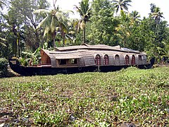
Asramam Adventure Park is an urban park in the core Kollam city of Kerala state. It was opened after 1980, on 48 acres (19 ha) of city-owned land. Located beside the Kerala's pride, backwaters of Ashtamudi, this place popularly known as Asramam Picnic Village. It is the main centre of recreational activities in Kollam city. The Kollam District Tourism Promotion Council conducts regular backwater cruises in houseboats, luxury boats and speedboats from the Boat Club. The mangroves near this park is very famous in all over India. So many endangered species of trees are surviving in the park.
Munroturuttu railway station or Mundrothuruthu railway station(Code:MQO) is an 'HG 2 Category' halt railway station, situated between Perinad and Sasthamkotta railway stations of Kollam district in Kerala state, India. The station is coming under the Southern Railway zone of Indian Railways. The nearest major rail head of Munrothuruthu railway station is Kollam Junction railway station.
Kollam or Quilon is an old seaport and a city on the Laccadive Sea coast in Kerala, India, on Ashtamudi Lake. The city remains notable as the ancient commercial capital of Kerala and the southwestern Indian coast, in addition to its fame as the "Cashew Capital of the World". The Kollam Municipal Corporation has the second largest budget in Kerala in terms of revenue and expenditure.
Kollam KSWTD Boat Jetty or Kollam KSWTD Ferry Station is an transport hub in the city of Kollam in Kerala, India, one of 14 ferry stations owned by the Kerala State Water Transport Department.
City of Kollam or Quilon is known as Prince of Arabian Sea, situated on the banks of Arabian Sea and Ashtamudi Lake. A major portion of Kollam Municipal Corporation area is occupied by Ashtamudi Lake. It is the most visited backwater and lake of Kerala, with a unique wetland ecosystem, a palm-shaped large water body, next only to the Vembanad estuary ecosystem of the state. Ashtamudi means 'eight coned'(Ashta = 'eight'; mudi = 'coned') in the local language of Malayalam. This name is indicative of the lake's topography: a lake with multiple branches. The lake is also called the gateway to the backwaters of Kerala. This lake is extremely famous for House Boat and Backwater Resorts.
The Paravur Estuaries are a group of estuaries in Paravur, India, near the South-Western coast of Kollam district, Kerala. Paravur is one among the 4 municipal towns in Kollam district, Kerala state. The place is known for its natural beauties, backwater locations, white-sand beaches and concentration of temples.
City of Kollam or Quilon is a Port city in South India and was the commercial capital of erstwhile Kingdom of Travancore. It is situated on the Laccadive Sea coast of South Kerala. The city is known as the "Gateway to the backwaters of Kerala". The city lies on the banks of Ashtamudi Lake, Kerala's second largest lake, on the Arabian sea coast. Major parts of Kollam city are covered by Ashtamudi Lake.
Kattaka Kayal or Kattakayal is a freshwater lake in Kollam city in the Kerala state of India. The lake connects Vattakayal, a 36-acre (15 ha) freshwater lake in Maruthadi, with Ashtamudi Lake in the city.
The fisheries industry in Kollam is a major economic driver for the city and the surrounding region. Kollam is located on the coast of Kerala, India, and has a number of major fishing ports. The city is also home to a number of fish processing plants, and it is a major exporter of fish products.