Sasthamcotta Lake

Last updated

Sasthamkotta Lake
Sasthamcotta Lake By ArunElectra.jpg
Sasthamkotta Lake
India Kerala relief map.png
Red pog.svg
Sasthamkotta Lake
Location Kollam, Kerala
Coordinates 9°02′N76°38′E / 9.03°N 76.63°E / 9.03; 76.63 Coordinates: 9°02′N76°38′E / 9.03°N 76.63°E / 9.03; 76.63
Native nameശാസ്താംകോട്ട കായൽ
Catchment area 12.69 km2 (4.90 sq mi)
Basin  countries India
Surface area373 ha (920 acres)
Average depth6.53 m (21.4 ft)
Max. depth15.2 m (50 ft)
Water volume22.4×10^6 m3 (790×10^6 cu ft)
Surface elevation33 m (108 ft)
Settlements Karunagapally and Sasthamkotta
Official nameSasthamkotta Lake
Designated19 August 2002
Reference no.1212 [1]

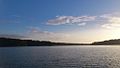
Sasthamcotta Lake or Sasthamkotta Lake, also categorized as a wetland, is the largest fresh water lake in Kerala, a state of India on the south of the West Coast. The lake is named after the ancient Sastha temple (a pilgrimage centre) located on its bank. It meets the drinking water needs of half million people of the Quilon district and also provides fishing resources. The purity of the lake water for drinking use is attributed to the presence of large population of larva called cavaborus that consumes bacteria in the lake water. [2] The lake is a designated wetland of international importance under the Ramsar Convention since November 2002. [3]

Contents

Access

The lake is located at a distance of 25 km from Quilon city, which is on the northern side of Ashtamudi Lake. Thiruvananthapuram International Airport, at 105 km, is the nearest airport to Kollam. Karunagapally, at a distance of 8 km, is the closest town to the lake. A ferry service across the lake transports people between West Kallada and Sasthamkotta. [2] [3]

Topography and geology

Except for an earthen embankment of 1.5 km length which separates the lake from the paddy fields on its southern side, bordering the alluvial plains of the Kallada River, all other sides of the lake are surrounded by hills which are steep and form narrow valleys. In the south and southwestern parts of the lake there are a number of smaller water bodies and waterlogged areas. [2] [4] The present area of the lake is 375 ha since large part of the lake is reported to have been occupied for agriculture. [5] Rock formation of mainly archaean origin are recorded with intrusions of charnockite, biotite gneiss and dolerite dyke rocks. The Tertiary Varkala formations are observed along the coastal beds. In the valley portion, sand and silt deposits are recorded. Geomorphological divisions of the basin area of the lake comprise a) the undulating uplands which have fairly thick vegetation of mixed crops and plantations, b) the valley fills of laterite alluvium and colluvial deposits with low level areas which are intensely cultivated and thickly populated and c) the flood plains/alluvial plains of the Kallada River on the south that are mostly cultivated. [2]

Hydrology

There are no visible tributaries feeding the lake but springs at the bottom of the lake are stated to be one of the source which supply water throughout the year; volume of water in the lake is estimated to be of the order of 22.4 million cum. [5] [6] A thick 1020 m mantle of kaolinite rich (derivative of laterite) soil around the lake is stated to check flow into the lake and the theory is now that the lake is also rain fed; the lake water level is recorded to be higher at the end of the monsoon season. [2] The average annual rainfall in the area is 2398 mm and mean annual temperature varies between 26.7 °C and 29.16 °C. [2] Ground water table in the area is reported at depth of 3.89 m. After accounting for estimated evaporation loss of 5 MCM (million cubic metres) and water utilized for domestic use of 8 MCM (at a pumpage rate of 22 MLD), the two together account for about two-thirds of the inflow. [2]

Water quality

The lake water is reported to be free of common salt or other minerals and metals. The quality for surface water, interstitial water and sediments studied [2] by World Wildlife Fund (WWF), India are briefly as noted below.

Quality for surface water (average values):

Water quality test results indicate that the lake water conforms to standards of drinking water prescribed by regulatory bodies. [2]

Flora

Eastern shore of the lake has the insectivorous plant Drosera Sp. Vegetation is negligible and rooted plants and floating plants are unimportant and insignificant. The crops grown on the banks of the lake, apart from paddy, are the plantation crops such as cashewnut, tapioca and plantain. [2] [7]

Aqua fauna

The aqua fauna noted in the lake [7] are:

The common teal or dabbling duck is the smallest migratory bird found in the lake. [7]

Some of the vulnerable, endangered and critically endangered species reported by WWF in the lake area [2] are:

Fauna

Resident troupes of monkeys are sighted on the banks in large numbers, which are part of the Sasthamkotta temple environment on the bank of the lake. [7] 13 species of insects have also been identified; 9 are butterflies, 2 odonates and 2 hymenopterans. [2]

Deterioration in lake environment

The quality of the lake environment is affected by the following factors. [2] [5]

Conservation and management

The Kerala State Government prepared a Conservation and Management Action Plan (MAP) in 1999 for the lake's sustainable utilization and conservation and to address the threats faced by the lake. Financial support was sought from the Central Government under the National Lake Conservation Plan (NLCP) for implementation of MAP based on the specific problems identified in the wetland. [8]

The MAP envisages the following activities: [4]

The above activities were planned to be implemented through the Kerala Water Authority (KWA), Department of Forests and Wild Life, Department of Fisheries, State Fisheries Resource Management Society (FIRMA), District Rural Development Agency (DRDA), CWRDM, etc. Kerala State Council for Science Technology and Environment of Govt. of Kerala provided the support and overall supervision. [4]

See also

Related Research Articles

Kollam Metropolis in South India, India

Kollampronunciation , known by its former name Quilonpronunciation  and Koolam, Coulão, and Desinganadu, is an ancient seaport and city on the Arabian Sea coast of the Indian state of Kerala. It is situated 66 kilometers north of the state capital Trivandrum. The city is on the banks of Ashtamudi Lake and the Kallada river.

Kerala backwaters Overview about the backwaters in Kerala, India

The Kerala backwaters are a network of brackish lagoons and lakes lying parallel to the Arabian Sea coast of Kerala state in southern India, as well as interconnected canals, rivers, and inlets, a labyrinthine system formed by more than 900 kilometres (560 mi) of waterways, and sometimes compared to American bayous. The network includes five large lakes linked by canals, both man made and natural, fed by 38 rivers, and extending virtually half the length of Kerala state. The backwaters were formed by the action of waves and shore currents creating low barrier islands across the mouths of the many rivers flowing down from the Western Ghats range. In the midst of this landscape there are a number of towns and cities, which serve as the starting and end points of backwater cruises.

Vembanad Largest lake in India

Vembanad is the longest lake in India, as well as the largest lake in the state of Kerala. With an area of 2033 square kilometers, it is the second largest Ramsar site in India only after the Sunderbans in West Bengal. Spanning several districts in the state of Kerala, it is known as Vembanadu Lake in Kottayam, Vaikom, Changanassery, Punnamada Lake in Alappuzha, Punnappra, Kuttanadu and Kochi Lake in Kochi. Several groups of small islands including Vypin, Mulavukad, Maradu, Udayamperoor, Vallarpadam, Willingdon Island are located in the Kochi Lake portion. Kochi Port is built around the Willingdon Island and the Vallarpadam island. Kuttanad, which lies on the bank of Vembanad, has the least altitude in India.

Ashtamudi Lake Lake in India (Gateway to the backwaters)

Ashtamudi Lake, in the Kollam District of the Indian state of Kerala, is the most visited backwater and lake in the state. It possesses a unique wetland ecosystem and a large palm-shaped water body, second only in size to the Vembanad estuary ecosystem of the state. Ashtamudi means 'eight braids' in the local Malayalam language. The name is indicative of the lake's topography with its multiple branches. The lake is also called the gateway to the backwaters of Kerala and is well known for its houseboat and backwater resorts. Ashtamudi Wetland was included in the list of wetlands of international importance, as defined by the Ramsar Convention for the conservation and sustainable utilization of wetlands.

Kollam district is one of 14 districts of the state of Kerala, India. The district has a cross-section of Kerala's natural attributes; it is endowed with a long coastline, a major Laccadive Sea seaport and an inland lake. The district has many water bodies. Kallada River is one among them, and the east side land of river is East Kallada and the west side land is West Kallada.

Munroe Island Inland island group in Kollam

Munroe Island or Mundrothuruthu is an inland island group located at the confluence of Ashtamudi Lake and the Kallada River, in Kollam district, Kerala, South India. It is a group of eight small islets comprising a total area of about 13.4 km2. The island, accessible by road, rail and inland water navigation, is about 25 kilometres (16 mi) from Kollam by road, 38 kilometres (24 mi) north from Paravur, 12 kilometres (7.5 mi) west from Kundara and about 25 kilometres (16 mi) from Karunagapally. As of the 2011 Indian census, the administrative village of Mundrothuruth has a total population of 9599, consisting of 4636 males and 4963 females.

Sooranad Village in Kerala, India

Sooranad North is a village in Kollam district in the south west Indian state of Kerala.

Kallada River

Kallada River/Kulathupuzha River is the longest river in Kollam District,Kerala,India.The river Origin from Kulathupuzha in part of Western Ghats also known as Kulathupuzha River.

Kulathupuzha Village in Kerala, India

Kulathupuzha (കുളത്തൂപ്പുഴ) is a township on the eastern part of Kollam district in Kerala, India. One of the largest Panchayat in State. This town is situated on Kallada River/Kulathupuzha River bank and Thiruvananthapuram – Thenmal "SH-2" road State Highway-2 & Thiruvananthapuram-Kasaragod State Highway SH 59. Kulathupuzha is 62 km away from Thiruvananthapuram, 58 km away from Kollam and 9 km from Thenmala Eco Tourism Project

Karunagappalli municipality in Kerala, India

Karunagappally is a municipality in the Kollam district of Kerala, India. It is 24 km north of Kollam and 60 km (37 mi) south of Alappuzha. Karunagappally taluk consists of Alappad, Ochira, Adinad, Karunagappally, Thazhava, Pavumba, Thodiyoor, Kallalibhagom, Thevalakkara, Chavara, Neendakara, Clappana, Kulasekharapuram, Thekkumbhagam, Ayanivelikulangara, Panmana, Ponmana and Vadakumthala. The taluk is bound on the north by Kayamkulam, on the east by Kunnathur taluk, on the south by Kollam and on the west by the Arabian Sea. It is one of the fastest developing towns in Kerala and is part of Kollam metropolitan area.

Kunnathur (Kunnattūr,കുന്നത്തൂർ) is a taluk in Kollam district in the Indian state of Kerala.

C. V. Ananda Bose

C. V. Ananda Bose is a veteran civil servant who served in the Indian Administrative Service.

Sakthikulangara Zone & Neighbourhood in Kollam, Kerala, India

Sakthikulangara is a zone and neighbourhood situated at the coastal area of the city of Kollam in Kerala India. It is one among the 6 zonal headquarters of Kollam Municipal Corporation.

Thevally Neighbourhood in Kollam, Kerala, India

Thevally is located in the city of Kollam, in the state of Kerala, India. Ashtamudi Lake is situated in the vicinity. National Highway-183 passes through the neighbourhood.

Economy of Kollam

Kollam or Quilon is an old seaport and a city on the Laccadive Sea coast in Kerala, India, on Ashtamudi Lake. The city remains notable as the ancient commercial capital of Kerala and the southwestern Indian coast, in addition to its fame as the "Cashew Capital of the World". The Kollam Municipal Corporation has the third largest budget in Kerala in terms of revenue and expenditure, after Trivandrum and Kochi.

Kollam KSWTD Ferry Terminal

Kollam KSWTD Boat Jetty or Kollam KSWTD Ferry Station is an transport hub in the city of Kollam in Kerala, India, one of 14 ferry stations owned by the Kerala State Water Transport Department.

Islands of Kollam

City of Kollam or Quilon is known as Prince of Arabian Sea, situated on the banks of Arabian Sea and Ashtamudi Lake. A major portion of Kollam Municipal Corporation area is occupied by Ashtamudi Lake. It is the most visited backwater and lake of Kerala, with a unique wetland ecosystem, a palm-shaped large water body, next only to the Vembanad estuary ecosystem of the state. Ashtamudi means 'eight coned'(Ashta = 'eight'; mudi = 'coned') in the local language of Malayalam. This name is indicative of the lake's topography: a lake with multiple branches. The lake is also called the gateway to the backwaters of Kerala. This lake is extremely famous for House Boat and Backwater Resorts.

Kollam district, earlier called Quilon district, is one of the 14 districts of Kerala state, India. The district is representative of all the natural attributes of Kerala states, and is endowed with a long coastal region, a major sea port on the Arabian Sea, plains and the mountains, lakes, lagoons and Kerala Backwaters, forests and the farm land, and rivers and streams. The area had mercantile relationship with Phoenicians and the Romans.

Kunnathur (State Assembly constituency)

Kunnathur is the only Scheduled Caste reserved legislative assembly constituency in Kollam district of Kerala, India. It is one among the 11 assembly constituencies in the district. As of the 2021 assembly elections, the current MLA is Kovoor Kunjumon of RSP(L)

References

  1. "Sasthamkotta Lake - Ramsar Sites Information Service". Rsis.ramsar.org. Retrieved 16 August 2018.
  2. 1 2 3 4 5 6 7 8 9 10 11 12 13 "Archived copy" (PDF). Archived from the original (PDF) on 27 May 2011. Retrieved 24 October 2008.CS1 maint: archived copy as title (link)
  3. 1 2 "Archived copy". Archived from the original on 25 July 2008. Retrieved 24 October 2008.CS1 maint: archived copy as title (link)
  4. 1 2 3 "Archived copy" (PDF). Archived from the original (PDF) on 10 April 2009. Retrieved 24 October 2008.CS1 maint: archived copy as title (link)
  5. 1 2 3 "Archived copy". Archived from the original on 14 October 2008. Retrieved 24 October 2008.CS1 maint: archived copy as title (link)
  6. "Sasthamcotta Lake (Kayal) Sasthamkotta. KOLLAM - Wikimapia". Wikimapia.org. Retrieved 16 August 2018.
  7. 1 2 3 4 "Sasthamkotta Lake Kollam, Sasthamkotta Lake Travel India, SasthamkottaLake Kollam India". Surfindia.com. Retrieved 16 August 2018.
  8. "Economic Valuation of Bhoj Wetlands for Sustainable Use" (PDF). Irade.org. pp. 30–32. Retrieved 16 August 2018.