Distributary

Last updated
Rhine-Meuse-Scheldt delta, with the flow from right to left, showing several streams branching off from their main streams RMSDeltaNorth.jpg
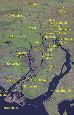
Rhine–Meuse–Scheldt delta, with the flow from right to left, showing several streams branching off from their main streams

A distributary, or a distributary channel, is a stream that branches off and flows away from a main stream channel, a phenomenon known as river bifurcation. A distributary is effectively the opposite of a tributary, which is a stream that flows towards and into another stream or river. Distributaries are often found where a stream approaches a lake or an ocean; as such, they are a common feature of river deltas. They can also occur inland, on alluvial fans, or where a tributary stream bifurcates as it nears its confluence with a larger stream. In some cases, a minor distributary can divert so much water from the main channel that it can later become the main route.

Contents

Common terms to name individual river distributaries in English-speaking countries are arm and channel. These terms may refer to a distributary that does not rejoin the channel from which it has branched (e.g., the North, Middle, and South Arms of the Fraser River, or the West Channel of the Mackenzie River), or to one that does (e.g. Annacis Channel and Annieville Channel of the Fraser River, separated by Annacis Island).

In Australia, the term anabranch is used to refer to a distributary that diverts from the main course of the river and rejoins it later. In North America an anabranching river is called a braided stream.

North America

Atchafalaya River Atchafalaya River.png
Atchafalaya River

In Louisiana, the Atchafalaya River is an important distributary of the Mississippi River. Because the Atchafalaya takes a steeper route to the Gulf of Mexico than does the Mississippi, over several decades the Atchafalaya has captured more and more of the Mississippi's flow, after the Mississippi meandered into the Red River of the South. The Old River Control Structure, a dam which regulates the outflow from the Mississippi into the Atchafalaya, was completed by the Army Corps of Engineers in 1963. The dam is intended to prevent the Atchafalaya from capturing the main flow of the Mississippi and stranding the ports of Baton Rouge and New Orleans. [1]

In British Columbia, Canada, the Fraser River has numerous sloughs and side-channels which may be defined as distributaries. This river's final stretch has three main distributaries: the North Arm and the South Arm, and a few smaller ones adjoining them.

Examples of inland distributaries:

South America

The Casiquiare canal is an inland distributary of the upper Orinoco, which flows southward into the Rio Negro, forming a unique natural canal between the Orinoco and Amazon river systems. It is the largest river on the planet that links two major river systems.

Europe

Satellite image of part of the Rhine-Meuse-Scheldt delta Maas Delta1.jpg
Satellite image of part of the Rhine–Meuse–Scheldt delta

Asia

Eastern Asia

The Huai River in China splits into three streams. The main stream passes through the Sanhe Sluice, goes out of the Sanhe river, and enters the Yangtze River through Baoying Lake and Gaoyou Lake. On the east bank of Hongze Lake, another stream goes out of Gaoliangjian Gate and enters the Yellow Sea at the port of Bidan through Subei Guan'gai Zongqu, the main irrigation channel of Northern Jiangsu); its total length is 168 kilometers. The third stream leaves the Erhe lock on the northeast bank of Hongze Lake, passes the Huaishuhe River to the north of Lianyungang city, and flows into Haizhou Bay through the Hongkou.

Southeast Asia

The Tha Chin River and Noi River are distributaries of the Chao Phraya River in Thailand, splitting off from the latter about 200 kilometers upstream from the Bay of Bangkok.

Indian Subcontinent

A seasonal distributary of the Kaveri River on the Kaveri delta, near Nannilam, India NearNannilam.jpg
A seasonal distributary of the Kaveri River on the Kaveri delta, near Nannilam, India

Africa

See History of the Nile Delta.

Oceania

Delta of Papua New Guinea's Fly River Fly River Delta-txu-oclc-6552576-sc54-4.jpg
Delta of Papua New Guinea's Fly River

Australia

A number of the rivers that flow inland from Australia's Great Dividing Range form distributaries, most of which flow only intermittently during times of high river levels and end in shallow lakes or simply peter out in the deserts. Yarriambiack Creek, which flows from the Wimmera River into Lake Coorong, and Tyrrell Creek, which flows from the Avoca River into Lake Tyrrell, are two distributaries in Victoria. The Narran River flows from the Balonne River in Queensland into Narran Lake in New South Wales.

Papua New Guinea

Many of Papua New Guinea's major rivers flow into the Gulf of Papua through marshy, low-lying country, allowing for wide, many-branched deltas. These include the Fly River, which splits into three major and several minor rivers close to its mouth. The Bamu River splits into several channels close to its mouth, among them the Bebea, Bina, Dibiri, and Aramia. The Kikori River also splits into a multitude of channels as it crosses the plains close to the Gulf of Papua. The Purari River splits into three major channels as it approaches its mouth.

New Zealand

New Zealand's second-longest river, the Clutha River, splits into two arms, the Matau and the Koua , some 10 kilometres from the South Island's Pacific Coast. A large island, Inch Clutha, lies between the two arms. Many of the rivers crossing the Canterbury Plains in the central South Island are braided rivers, and several of these split into separate branches before reaching the coast. Notable among these is the Rangitata River, the two arms of which are separated by the low-lying Rangitata Island.

Related Research Articles

<span class="mw-page-title-main">IJssel</span> River in the Netherlands

The IJssel is a Dutch distributary of the river Rhine that flows northward and ultimately discharges into the IJsselmeer, a North Sea natural harbour. It more immediately flows into the east-south channel around the Flevopolder, Flevoland which is kept at 3 metres below sea level. This body of water is then pumped up into the IJsselmeer.

<span class="mw-page-title-main">Tributary</span> Stream or river that flows into a main stem river or lake

A tributary, or affluent, is a stream or river that flows into a larger stream or main stem river or a lake. A tributary does not flow directly into a sea or ocean. Tributaries and the main stem river drain the surrounding drainage basin of its surface water and groundwater, leading the water out into an ocean. The Irtysh is a chief tributary of the Ob river and is also the longest tributary river in the world with a length of 4,248 km (2,640 mi). The Madeira River is the largest tributary river by volume in the world with an average discharge of 31,200 m3/s (1.1 million cu ft/s).

<span class="mw-page-title-main">River delta</span> Silt deposition landform at the mouth of a river

A river delta is a landform shaped like a triangle, created by the deposition of sediment that is carried by a river and enters slower-moving or stagnant water. This occurs when a river enters an ocean, sea, estuary, lake, reservoir, or another river that cannot carry away the supplied sediment. It is so named because its triangle shape resembles the Greek letter Delta. The size and shape of a delta are controlled by the balance between watershed processes that supply sediment, and receiving basin processes that redistribute, sequester, and export that sediment. The size, geometry, and location of the receiving basin also plays an important role in delta evolution.

<span class="mw-page-title-main">Red River of the South</span> Major river in the southern United States

The Red River, or sometimes the Red River of the South, is a major river in the Southern United States. It was named for its reddish water color from passing through red-bed country in its watershed. It is known as the Red River of the South to distinguish it from the Red River of the North, which flows between Minnesota and North Dakota into the Canadian province of Manitoba. Although once a tributary of the Mississippi River, the Red River is now a tributary of the Atchafalaya River, a distributary of the Mississippi that flows separately into the Gulf of Mexico. This confluence is connected to the Mississippi River by the Old River Control Structure.

<span class="mw-page-title-main">Atchafalaya River</span> Distributary of the Mississippi River in Louisiana, United States

The Atchafalaya River is a 137-mile-long (220 km) distributary of the Mississippi River and Red River in south central Louisiana in the United States. It flows south, just west of the Mississippi River, and is the fifth largest river in North America, by discharge. The name Atchafalaya comes from Choctaw for 'long river', from hachcha, 'river', and falaya, 'long'.

<span class="mw-page-title-main">Feather River</span> River in California, United States

The Feather River is the principal tributary of the Sacramento River, in the Sacramento Valley of Northern California. The river's main stem is about 73 miles (117 km) long. Its length to its most distant headwater tributary is just over 210 miles (340 km). The main stem Feather River begins in Lake Oroville, where its four long tributary forks join—the South Fork, Middle Fork, North Fork, and West Branch Feather Rivers. These and other tributaries drain part of the northern Sierra Nevada, and the extreme southern Cascades, as well as a small portion of the Sacramento Valley. The total drainage basin is about 6,200 square miles (16,000 km2), with approximately 3,604 square miles (9,330 km2) above Lake Oroville.

<span class="mw-page-title-main">Stillaguamish River</span> River in Washington, United States

The Stillaguamish River is a river in the northwestern region of the U.S. state of Washington. It is mainly composed of two forks, the longer North Fork Stillaguamish and the South Fork Stillaguamish. The two forks join near Arlington. From there the Stillaguamish River proper flows for 22 miles (35 km) to Puget Sound. The river's watershed drains part of the Cascade Range north of Seattle.

<span class="mw-page-title-main">Old River Control Structure</span> Floodgate system in Louisiana, USA

The Old River Control Structure is a floodgate system in a branch of the Mississippi River in central Louisiana. It regulates the flow of water from the Mississippi into the Atchafalaya River, thereby preventing the Mississippi River from changing course. Completed in 1963, the complex was built by the U.S. Army Corps of Engineers in a side channel of the Mississippi known as "Old River", between the Mississippi's current channel and the Atchafalaya Basin, a former channel of the Mississippi.

<span class="mw-page-title-main">Tule River</span> River in California, United States

The Tule River, also called Rio de San Pedro or Rio San Pedro, is a 71.4-mile (114.9 km) river in Tulare County in the U.S. state of California. The river originates in the Sierra Nevada east of Porterville and consists of three forks, North, Middle and South. The North Fork and Middle Fork meet above Springville. The South Fork meets the others at Lake Success. Downstream of Success Dam, the river flows west through Porterville. The river used to empty into Tulare Lake, but its waters have been diverted for irrigation. However, the river does reach Tulare Lake during floods. Tulare Lake is the terminal sink of an endorheic basin that historically also received the Kaweah and Kern Rivers as well as southern distributaries of the Kings.

<span class="mw-page-title-main">River island</span> Exposed landmass within a river

A river island is any exposed landmass surrounded by river water. Properly defined, it excludes shoals between seasonally varying flows and may exclude semi-coastal islands in river deltas such as Marajó.

<span class="mw-page-title-main">Atchafalaya Basin</span> Largest wetland and swamp in the United States

The Atchafalaya Basin, or Atchafalaya Swamp, is the largest wetland and swamp in the United States. Located in south central Louisiana, it is a combination of wetlands and river delta area where the Atchafalaya River and the Gulf of Mexico converge. The river stretches from near Simmesport in the north through parts of eight parishes to the Morgan City southern area.

<span class="mw-page-title-main">Kalahari Basin</span> African endorheic basin

<span class="mw-page-title-main">Kaweah River</span> River in the United States of America

The Kaweah River is a river draining the southern Sierra Nevada in Tulare County, California in the United States. Fed primarily by high elevation snowmelt along the Great Western Divide, the Kaweah begins as four forks in Sequoia National Park, where the watershed is noted for its alpine scenery and its dense concentrations of giant sequoias, the largest trees on Earth. It then flows in a southwest direction to Lake Kaweah – the only major reservoir on the river – and into the San Joaquin Valley, where it diverges into multiple channels across an alluvial plain around Visalia. With its Middle Fork headwaters starting at almost 13,000 feet (4,000 m) above sea level, the river has a vertical drop of nearly two and a half miles (4.0 km) on its short run to the San Joaquin Valley, making it one of the steepest river drainages in the United States. Although the main stem of the Kaweah is only 33.6 miles (54.1 km) long, its total length including headwaters and lower branches is nearly 100 miles (160 km).

<span class="mw-page-title-main">River bifurcation</span> The forking of a river into its distributaries

River bifurcation occurs when a river flowing in a single stream separates into two or more separate streams which then continue downstream. Some rivers form complex networks of distributaries, typically in their deltas. If the streams eventually merge again or empty into the same body of water, then the bifurcation forms a river island.

<span class="mw-page-title-main">Anabranch</span> A section of a river or stream that diverts from the main channel and rejoins it downstream.

An anabranch is a section of a river or stream that diverts from the main channel or stem of the watercourse and rejoins the main stem downstream. Local anabranches can be the result of small islands in the watercourse. In larger anabranches, the flow can diverge for a distance of several or even hundreds of kilometers before rejoining the main channel.

<span class="mw-page-title-main">Rhine–Meuse–Scheldt delta</span> Delta formed by 3 rivers in the Netherlands

The Rhine–Meuse–Scheldt delta is a river delta in the Netherlands formed by the confluence of the Rhine, the Meuse and the Scheldt rivers. In some cases, the Scheldt delta is considered a separate delta to the Rhine–Meuse delta. The result is a multitude of islands, branches and branch names, in which a waterway that appears to be one continuous stream may have numerous separate names for different sections, e.g. Rhine → Bijlands Kanaal → Pannerdens Kanaal → Nederrijn → Lek → Nieuwe Maas → Het Scheur → Nieuwe Waterweg. Since the Rhine contributes most of the water, the term "Rhine Delta" is commonly used, although this name is also used for the delta where the Alpine Rhine flows into Lake Constance. By some calculations, the Rhine–Meuse–Scheldt delta covers 25,347 km2 (9,787 sq mi), making it the largest in Europe.

<span class="mw-page-title-main">Stream</span> Body of surface water flowing down a channel

A stream is a continuous body of surface water flowing within the bed and banks of a channel. Depending on its location or certain characteristics, a stream may be referred to by a variety of local or regional names. Long, large streams are usually called rivers, while smaller, less voluminous and more intermittent streams are known as streamlets, brooks or creeks.

<span class="mw-page-title-main">Wax Lake</span>

Wax Lake was a lake in St. Mary Parish, Louisiana that was converted into an outlet channel, the Wax Lake outlet, to divert water from the Atchafalaya River to the Gulf of Mexico.

<span class="mw-page-title-main">River fork</span> Place where a river visually "splits"

A river fork is where a river is connected to two or more clearly and equally distinct branches. It describes both tributaries and distributaries.

References

Citations