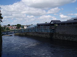
The Abbey River (Irish: Abhainn na Mainistreach) is a distributary arm of the River Shannon that flows around the northeastern, eastern, and southern shores of King's Island, Limerick before rejoining the Shannon at Hellsgate Island.[1][2]Hellsgate Island is only visible at low tide.[3] It is bridged by the Abbey Bridge, Baals Bridge, the Canal Bridge, Matthew Bridge, O'Dwyer Bridge, and the Sylvester O'Halloran Footbridge.
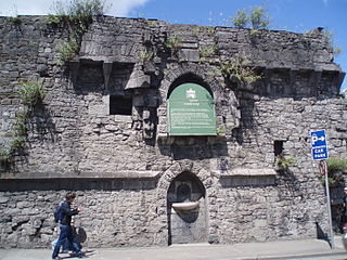
King's Island's encirclement by the Shannon and Abbey rivers made it a very defensible location, leading to the founding of Limerick as a Viking settlement in the ninth century.[4] The Abbey River has played a defensive role throughout the city's history, not least during the Cromwelliansiege of 1650-51,[5] and the Williamitesiege of 1691.[6] It is named after the former Franciscan Abbey located next to the river.
In the early 2000s, a number of historical artefacts were discovered when the river was drained. These included Limerick Port seal, intact mortar bombs from the 1690s and a Viking Age bronze artefact, circa AD 1000.[7]
↑ Simms, J.G. (1986). War and Politics in Ireland, 1649-1730. London: Hambledon Press. p.22. ISBN978-0907628729. Retrieved 23 October 2013. The Shannon divides at Limerick; a branch, called the Abbey river, makes an island which was called the King's Island.
↑ "Abbey River, Ireland". Geographical Names. National Geospatial-Intelligence Agency, Bethesda, Maryland, US. 5 May 1998. Archived from the original on 29 October 2013. Retrieved 23 October 2013.
↑ Seán Duffy, ed. (1 December 2004). Medieval Ireland: An Encyclopedia. CRC Press. p.458. ISBN0203502671. Viking raiding parties used the Shannon from the 830s, attacking churches along its route and, by mid-century, had established a settlement at Limerick, building a fortress on Inis Sibtond. It was a very strategic site, protected from the west by the Shannon and elsewhere by the Abbey River.
↑ Burke, James (1 August 2001). "Siege Warfare in Seventeenth Century Ireland". In Lenihan, Pádraig (ed.). Conquest and resistance: war in seventeenth-century Ireland. Brill Academic Publishers. p.286. ISBN978-9004117433. Clearly it was Ginkel’s intention to launch an amphibious assault over the Abbey and then cross the boggy ground to the breach…. Such an assault would present many dangers. The river was not fordable and a bridge would have to be constructed under fire.
Limerick is a western city in Ireland situated within County Limerick. It is in the province of Munster and is located in the Mid-West which comprises part of the Southern Region. With a population of 94,192 at the 2016 census, Limerick is the third-most populous urban area in the state, and the fourth-most populous city on the island of Ireland at the 2011 census. The city lies on the River Shannon, with the historic core of the city located on King's Island, which is bounded by the Shannon and Abbey Rivers. Limerick is also located at the head of the Shannon Estuary, where the river widens before it flows into the Atlantic Ocean. Limerick City and County Council is the local authority for the city.
The River Shannon, at 360.5 km in length, is the longest river in the British Isles It drains the Shannon River Basin, which has an area of 16,865 km2 (6,512 sq mi), - one fifth of the area of the island.
County Limerick is a western county in Ireland. It is in the province of Munster and is located in the Mid-West which comprises part of the Southern Region. It is named after the city of Limerick. Limerick City and County Council is the local council for the county. The county's population at the 2016 census was 194,899 of whom 94,192 lived in Limerick City, the county capital.
Athlone is a town on the border of County Roscommon and County Westmeath, Ireland. It is located on the River Shannon near the southern shore of Lough Ree. It is the second most populous town in the Midlands Region with a population of 21,349 in the 2016 census.
The history of Limerick stretches back to its establishment by Vikings as a walled city on King's Island in 812, and to the granting of Limerick's city charter in 1197.
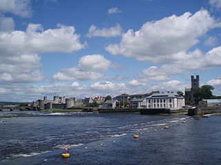
King John's Castle also known as Limerick Castle is a 13th-century castle located on King's Island in Limerick, Ireland, next to the River Shannon. Although the site dates back to 922 when the Vikings lived on the Island, the castle itself was built on the orders of King John in 1200. One of the best preserved Norman castles in Europe, the walls, towers and fortifications remain today and are visitor attractions. The remains of a Viking settlement were uncovered during archaeological excavations at the site in 1900.
King's Island is an area of central Limerick, Ireland. The area is often referred to colloquially as The Island and consists of two distinct areas, Englishtown and St Mary's Park. The historical city of Limerick known as Englishtown is located on the southern end and St Mary's Park; a local authority housing estate is located on the northern end.
Killaloe is a large village in east County Clare, Ireland. The village lies on the River Shannon on the western bank of Lough Derg and is connected by Killaloe Bridge to the "twin town" of Ballina on the eastern bank of the lake.
The Williamite War in Ireland, was a conflict between Jacobite supporters of deposed monarch James II and Williamite supporters of his successor, William III. It is also called the Jacobite War in Ireland, Williamite Conquest of Ireland, or the Williamite–Jacobite War in Ireland.
As with other cities in Ireland, Limerick has a history of great architecture. A 1574 document prepared for the Spanish ambassador attests to its wealth and fine architecture:
The Cromwellian conquest of Ireland or Cromwellian war in Ireland (1649–1653) was the re-conquest of Ireland by the forces of the English Parliament, led by Oliver Cromwell, during the Wars of the Three Kingdoms. Cromwell invaded Ireland with the New Model Army on behalf of England's Rump Parliament in August 1649.
Inis Cathaigh or Scattery Island is an island in the Shannon Estuary, Ireland, off the coast of Kilrush, County Clare. The island is home to a lighthouse, a ruined monastery associated with Saint Senan, an Irish round tower and the remains of an artillery battery. The last residents left in 1969. Most of the island is now owned by the Office of Public Works, who run a small visitor centre and carry out repairs and maintenance on the island; it was bought by Dúchas in 1991.The Irish name Inis Cathaigh was formerly anglicised Iniscathy, which later became Iniscattery and finally Scattery.
Ballylongford is a village near Listowel in northern County Kerry, Ireland.
Athlone was besieged twice during the Williamite War in Ireland (1689–91). The town is situated in the centre of Ireland on the River Shannon and commanded the bridge crossing the river into the Jacobite-held province of Connacht. For this reason, it was of key strategic importance.
Limerick, in western Ireland was the scene of two sieges during the Irish Confederate Wars. The second and largest of these took place during the Cromwellian conquest of Ireland in 1650–51. Limerick was one of the last fortified cities held by an alliance of Irish Irish Confederates and Royalists against the forces of the English Parliament. Its garrison, led by Hugh Dubh O'Neill, surrendered to Henry Ireton after a protracted and bitter siege. Over 2,000 soldiers of Cromwell's New Model Army were killed at Limerick, and Henry Ireton, Cromwell's son-in-law, died of plague.
Athlone is a town on the River Shannon near the southern shore of Lough Ree in Ireland. Located on the border between County Westmeath and County Roscommon, the development of the Athlone owes much to the location of a strategic ford on the Shannon.
Carrigogunnell Castle is a medieval Irish fortification near the village of Clarina, on the banks of the River Shannon in County Limerick.
Irishtown is an area of central Limerick, Ireland. The area along with Englishtown and Newtown Pery forms Limerick City Centre. Broad Street, John Street and Mungret Street are the main streets in the district. St. John's Square, a prized early Georgian development is located here as is St. John's Cathedral and the Milk Market which is located off Mungret Street.
Athlunkard Street is a street on King's Island, in Limerick City, Ireland. The Irish name is, Áth Longphuirt, meaning "ford of the longphort," refers to a 9th-century Viking longphort once located at that ford over the Shannon. Athlunkard Street stretches from the Abbey River, at the O'Dwyer Bridge to the intersection with Mary Street and Nicholas Street.
Harald Sigtryggsson was a Viking leader who ruled Limerick in the early 10th century. He was the son of Sitric Cáech and great-grandson of Ímar, making him one of the Uí Ímair. He was installed as king of Limerick following the capture of the previous king Olaf Scabby-head by Harald's cousin Olaf Guthfrithson, king of Dublin, during a battle at Lough Ree in 937. Harald died in 940 and was ultimately succeeded by Ivar of Limerick.
This page is based on this Wikipedia article Text is available under the CC BY-SA 4.0 license; additional terms may apply. Images, videos and audio are available under their respective licenses.