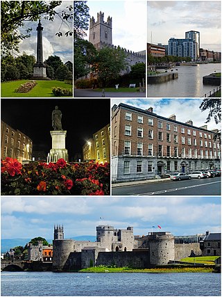
Limerick is a city in western Ireland, in County Limerick. It is in the province of Munster and is in the Mid-West which comprises part of the Southern Region. With a population of 102,287 at the 2022 census, Limerick is the third-most populous urban area in the Republic of Ireland, and the fourth-most populous city on the island of Ireland. It was founded by Scandinavian settlers in 812, during the Viking Age.

Caherdavin is a northern suburban district of Limerick city in the mid-west of Ireland. As of 2022, the population of Caherdavin is 7,364.

Ballyfermot is a suburb of Dublin, Ireland. It is located seven kilometres west of the city centre, south of Phoenix Park. It is bordered by Chapelizod on the north, by Bluebell on the south, by Inchicore on the east, and by Palmerstown and Clondalkin on the west. The River Liffey lies to the north, and the Grand Canal, now a recreational waterway, lies to the south of Ballyfermot. Ballyfermont lies within the postal district Dublin 10. Cherry Orchard, which is also a suburb, is sometimes considered to be within Ballyfermot.

Patrickswell, historically known as Toberpatrick, is a small town in County Limerick, Ireland. It is primarily a commuter village for people working in Limerick, including the nearby industrial suburb of Raheen. The population was 848 at the 2022 census.

Raheen is a large suburb of Limerick, Ireland. Initially developed to ease population overspill from the city of Limerick, Raheen is socioeconomically diverse, ranging from older, poor-class housing estates to relatively affluent areas.

Saggart is a village in County Dublin, Ireland, south west of Dublin city, in the local government area of South Dublin. It lies between the N7, Rathcoole, Citywest and Tallaght. It is one of the fastest-growing settlements in Ireland, with its population doubling between 2011 and 2022.
Crescent College Comprehensive SJ, formerly known as the College of the Sacred Heart, is a Catholic secondary school located on 40 acres (160,000 m2) of parkland at Dooradoyle, Limerick, Ireland. The college is one of a number of Jesuit schools in Ireland.
The Crescent Shopping Centre is a major shopping centre serving Limerick, Ireland. It is located in Dooradoyle, on the southern outskirts of the city. The complex in its original form was opened in 1973, making it one of the earlier shopping centres to open in Ireland. It has an estimated 100,000 m2 (1,100,000 sq ft) of space, 2,500 free car parking places and 94 shops. The shopping centre takes its name from the adjacent Crescent College, whose original building was in The Crescent in the city centre.
Mungret College was a Jesuit apostolic school and a lay secondary school near Limerick, Ireland. Located on the western outskirts of the modern-day suburban town of Raheen, it was operational from 1882 until 1974 when it closed as a school for the last time. The college produced over 1000 priests in that period. It had previously been an agricultural college and a Limerick diocesan seminary until 1888.

Crecora is a village in County Limerick, Ireland, located approximately 8 miles (13 km) from Limerick city. The village is partly in a civil parish of the same name.
Raheen is a townland and village in County Wexford, Ireland. It lies 27 km from Wexford, 11 km from New Ross, and 23 km from Enniscorthy.

Limerick is the third largest city in the Republic of Ireland and is the capital of Ireland's Mid-West Region comprising the counties of Limerick, Clare and North Tipperary. Traditionally Limerick's economy was mainly agricultural of which a lot of industry in the city was based around due to the city's proximity to the Golden Vale. Important industries at this time were the bacon industry and Limerick lace which provided much employment. Limerick Port was also the main port on the west of Ireland where much this produce was exported. Today Limerick's economy is driven by a cluster of industrial and business parks located along the Limerick/Shannon corridor which include the National Technology Park, Raheen Business Park and the Shannon Free Zone. Limerick/Shannon is also classified as a gateway city as part of the National Spatial Strategy.
Garryowen is a neighbourhood in Limerick, Ireland. The word Garryowen is a transliteration of the Irish Garraí Eoin - "the garden of Owen" - and relates to the association in the 12th century between St John's Church and the Knights Templar whose house in Limerick was dedicated to John the Baptist. In medieval times Garryowen was located just outside the Irishtown area of the walled city of Limerick. The citadel was the Irishtown's main fortification. In 1690, it was the scene of a heroic Jacobite defence-the battle of the breach-which was fought nearby during the Williamite War of 1688–91. The sally port of the original stronghold has been incorporated into the structure of St John's Hospital. Other parts of the city walls can still be seen within the hospital grounds. The Citadel remained in use as a military barracks until 1752. St John's Gate was situated on the main roadway, nearby, but no trace of it now remains.

Clarina is a village in County Limerick in the province of Munster, Ireland. It lies between Mungret and Kildimo on the N69 road 8 km (5 mi) west of the centre of Limerick city close to the River Maigue. The Maigue is a tributary of the River Shannon and enters the Shannon estuary between Limerick city and the mouth of the Deel river, Askeaton, county Limerick.

Newtown Pery is an area of central Limerick, Ireland, and forms the main city centre of the city. The district is known for its Georgian architectural heritage and is the core area of Limerick's Georgian Quarter. It is one of the three towns that make up modern-day Limerick City Centre, the other two being the older Englishtown and Irishtown, which date from the medieval period. Newtown Pery houses the largest collection of Georgian townhouses in Ireland outside of Dublin. In 1837, Samuel Lewis in his Topographical Dictionary of Ireland described Newtown Pery as "one of the handsomest towns in Ireland".
The Crescent is a street in Limerick, Ireland and is one of the highlights of Georgian Limerick. The area takes its name from the shape of the terraced buildings on both sides. The two sides combined give the street a distinctive crescent oval shape. The Crescent was originally known as Richmond Place . A monument to Daniel O'Connell; the 19th Century Irish political leader stands at the centre of The Crescent overlooking O'Connell Street.

Irishtown is an area of central Limerick, Ireland. The area along with Englishtown and Newtown Pery forms Limerick city centre. Broad Street, John Street and Mungret Street are the main streets in the district. St. John's Square, a prized early Georgian development is located here as is St. John's Cathedral and the Milk Market which is located off Mungret Street.

Fiona Doyle is an Irish swimmer. She represented Ireland in the 2016 Rio Olympics swimming in the 100M and 200M Breaststroke. In 2013, she competed in the 100m event at the World Aquatics Championships in Barcelona where she finished eleventh overall. She won a silver medal in the 100 m breaststroke at the 2013 Summer Universiade. In recognition of her achievements she was awarded Swim Alberta Female International Swimmer of the Year 2012/2013, University of Calgary female Athlete of the Year 2013 and SwimIreland High Performance Athlete of the Year 2013, 2014 and 2015.

Mungret Abbey is a medieval friary and National Monument located near Mungret in County Limerick, Ireland.

Mungret is a village and civil parish in County Limerick, Ireland. It is 6 km south-west of Limerick city centre, on the N69 road. As of the 2016 census, the village had a population of 277 people.
