Dromod or Drumod (Irish: Dromad, meaning 'long ridge, or back of the wood')[2] is a village in County Leitrim, Ireland.[3][4] Dromod is a fishing village beside Bofin and Boderg, which are threaded by the River Shannon. The village harbour is used by tourist vessels which cruise the Shannon. A water feature in the centre of the village, known as 'The Weeping Tree', was made by a local craftsman from a piece of bog oak which was found nearby.[5]
Between 2006 and 2022, the population of Dromod increased from 210 to 753,[1] an increase of 258.6%.
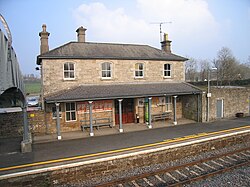
Dromod railway station
The village has a station on the Dublin-Sligo railway line connecting Sligo and Dublin Connolly long the mainline. Dromod railway station opened on 3 December 1862 and remains in operation, despite closing for goods services on 3 November 1975.[6] Dromod also had a railway station on the narrow gaugeCavan and Leitrim Railway. It opened on 24 October 1887 and finally closed on 1 April 1959.[6] A short section of narrow gauge line has been reopened at the station as part of preservation efforts.[7]
History
Dromod's former Garda station (closed in 2014)
In Gaelic Ireland the place was called "Dromode mac Shanley" in recognition of the dominant Mac Shanly sept of Muintir Eolais.[8] The town is mentioned once in the Irish Annals- "1473: A great war broke out in Muintir-Eolais; and much was destroyed between them, both by burning and slaying. An attack was made by Mac Rannall on the town of Mac Shanly, and the town was burned, and Donough, the son of Donough Mac Shanly, and many others, were slain by him".[9]
An Iron works was established at Dromod c.1693– c.95.[a]Pig iron brought to Dromod Finery forge was used to produce a malleable iron product, for transportation to Dublin and Limerick.[11][12][13] The operation was closed down in the 1790s, due to an exhaustion of forests locally.[10]
Through at least the 19th and 20th century, seven annual fairs were held at Dromod- 1 January, 28 March (or 29th), 15 May, 26 June (or 29th), 14 August, 10 October (or 11th), and 11 December.[14][15]
The N4 national road, which previously ran through the village, was routed around Dromod and neighbouring Roosky with the opening of the N4 Dromod Roosky Bypass in December 2007.[16]
↑Iron works at Dromod and Ballinamore, on land confiscated from the Irish during the plantations of Ireland, had been established around 1695, by English adventurers named Capt. William Slacke, John Skerret, and Joseph Hall.[10]
This page is based on this Wikipedia article Text is available under the CC BY-SA 4.0 license; additional terms may apply. Images, videos and audio are available under their respective licenses.