Related Research Articles

A canyon, or gorge, is a deep cleft between escarpments or cliffs resulting from weathering and the erosive activity of a river over geologic time scales. Rivers have a natural tendency to cut through underlying surfaces, eventually wearing away rock layers as sediments are removed downstream. A river bed will gradually reach a baseline elevation, which is the same elevation as the body of water into which the river drains. The processes of weathering and erosion will form canyons when the river's headwaters and estuary are at significantly different elevations, particularly through regions where softer rock layers are intermingled with harder layers more resistant to weathering.

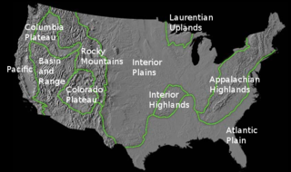
The Intermontane Plateaus of the Western United States is one of eight U.S. Physiographic regions (divisions) of the physical geography of the contiguous United States. The region is composed of intermontane plateaus and mountain ranges. It is subdivided into physiographic provinces, which are each subdivided into physiographic sections.
The richly textured landscape of the United States is a product of the dueling forces of plate tectonics, weathering and erosion. Over the 4.5 billion-year history of our Earth, tectonic upheavals and colliding plates have raised great mountain ranges while the forces of erosion and weathering worked to tear them down. Even after many millions of years, records of Earth's great upheavals remain imprinted as textural variations and surface patterns that define distinctive landscapes or provinces.

The geology of the Grand Canyon area includes one of the most complete and studied sequences of rock on Earth. The nearly 40 major sedimentary rock layers exposed in the Grand Canyon and in the Grand Canyon National Park area range in age from about 200 million to nearly 2 billion years old. Most were deposited in warm, shallow seas and near ancient, long-gone sea shores in western North America. Both marine and terrestrial sediments are represented, including lithified sand dunes from an extinct desert. There are at least 14 known unconformities in the geologic record found in the Grand Canyon.

The geology of the Zion and Kolob canyons area includes nine known exposed formations, all visible in Zion National Park in the U.S. state of Utah. Together, these formations represent about 150 million years of mostly Mesozoic-aged sedimentation in that part of North America. Part of a super-sequence of rock units called the Grand Staircase, the formations exposed in the Zion and Kolob area were deposited in several different environments that range from the warm shallow seas of the Kaibab and Moenkopi formations, streams and lakes of the Chinle, Moenave, and Kayenta formations to the large deserts of the Navajo and Temple Cap formations and dry near shore environments of the Carmel Formation.
The exposed geology of the Bryce Canyon area in Utah shows a record of deposition that covers the last part of the Cretaceous Period and the first half of the Cenozoic era in that part of North America. The ancient depositional environment of the region around what is now Bryce Canyon National Park varied from the warm shallow sea in which the Dakota Sandstone and the Tropic Shale were deposited to the cool streams and lakes that contributed sediment to the colorful Claron Formation that dominates the park's amphitheaters.

The exposed geology of the Canyonlands area is complex and diverse; 12 formations are exposed in Canyonlands National Park that range in age from Pennsylvanian to Cretaceous. The oldest and perhaps most interesting was created from evaporites deposited from evaporating seawater. Various fossil-rich limestones, sandstones, and shales were deposited by advancing and retreating warm shallow seas through much of the remaining Paleozoic.

The exposed geology of the Capitol Reef area presents a record of mostly Mesozoic-aged sedimentation in an area of North America in and around Capitol Reef National Park, on the Colorado Plateau in southeastern Utah.

A water gap is a gap that flowing water has carved through a mountain range or mountain ridge and that still carries water today. Such gaps that no longer carry water currents are called wind gaps. Water gaps and wind gaps often offer a practical route for road and rail transport to cross the mountain barrier.

The Kali Gandaki Gorge or Andha Galchi is the gorge of the Kali Gandaki in the Himalayas in Nepal. By some definitions, it may be one of the deepest gorges in the world.

In geomorphology a river is said to be rejuvenated when it is eroding the landscape in response to a lowering of its base level. The process is often a result of a sudden fall in sea level or the rise of land. The disturbance enables a rise in the river's potential energy, increasing its riverbed erosion rate. The erosion occurs as a result of the river adjusting to its new base level.

Stream capture, river capture, river piracy or stream piracy is a geomorphological phenomenon occurring when a stream or river drainage system or watershed is diverted from its own bed, and flows instead down the bed of a neighbouring stream. This can happen for several reasons, including:

A meander is one of a series of regular sinuous curves in the channel of a river or other watercourse. It is produced as a watercourse erodes the sediments of an outer, concave bank and deposits sediments on an inner, convex bank which is typically a point bar. The result of this coupled erosion and sedimentation is the formation of a sinuous course as the channel migrates back and forth across the axis of a floodplain.

Devil's Gate or Devils Gate is a natural rock formation, a gorge on the Sweetwater River in Wyoming, United States, five miles (8 km) southwest of Independence Rock. Although the actual route of travel did not pass through the narrow cleft, the site was a major landmark on the Oregon and Mormon trails, and is particularly significant in the history of the latter.

Headward erosion is erosion at the origin of a stream channel, which causes the origin to move back away from the direction of the stream flow, lengthening the stream channel. It can also refer to widening of a canyon by erosion along its very top edge, when sheets of water first enter the canyon from a more roughly planar surface above it, such as at Canyonlands National Park in Utah. When sheets of water on a roughly planar surface first enter a depression in it, this erodes the top edge of the depression. The stream is forced to grow longer at the very top of the stream, which moves its origin back, or causes the canyon formed by the stream to grow wider as the process repeats. Widening of the canyon by erosion inside the canyon, below the canyon side top edge, or origin or the stream, such as erosion caused by the streamflow inside it, is not called headwall erosion.

The Geology of Pennsylvania consists of six distinct physiographic provinces, three of which are subdivided into different sections. Each province has its own economic advantages and geologic hazards and plays an important role in shaping everyday life in the state. They are: the Atlantic Coastal Plain Province, the Piedmont Province, the New England Province, the Ridge and Valley Province, the Appalachian Plateau Province, and the Central Lowlands Province.

In geomorphology, drainage systems, also known as river systems, are the patterns formed by the streams, rivers, and lakes in a particular drainage basin. They are governed by the topography of land, whether a particular region is dominated by hard or soft rocks, and the gradient of the land. Geomorphologists and hydrologists often view streams as part of drainage basins. This is the topographic region from which a stream receives runoff, throughflow, and its saturated equivalent, groundwater flow. The number, size, and shape of the drainage basins varies and the larger and more detailed the topographic map, the more information is available.

A river is a natural flowing watercourse, usually freshwater, flowing towards an ocean, sea, lake or another river. In some cases, a river flows into the ground and becomes dry at the end of its course without reaching another body of water. Small rivers can be referred to using names such as stream, creek, brook, rivulet, and rill. There are no official definitions for the generic term river as applied to geographic features, although in some countries or communities a stream is defined by its size. Many names for small rivers are specific to geographic location; examples are "run" in some parts of the United States, "burn" in Scotland and northeast England, and "beck" in northern England. Sometimes a river is defined as being larger than a creek, but not always: the language is vague.

The Colorado River is a major river of the western United States and northwest Mexico in North America. Its headwaters are in the Rocky Mountains where La Poudre Pass Lake is its source. Located in north central Colorado it flows southwest through the Colorado Plateau country of western Colorado, southeastern Utah and northwestern Arizona where it flows through the Grand Canyon. It turns south near Las Vegas, Nevada, forming the Arizona–Nevada border in Lake Mead and the Arizona–California border a few miles below Davis Dam between Laughlin, Nevada and Needles, California before entering Mexico in the Colorado Desert. Most of its waters are diverted into the Imperial Valley of Southern California. In Mexico its course forms the boundary between Sonora and Baja California before entering the Gulf of California. This article describes most of the major features along the river.

In geology, 3D fold evolution is the study of the full three dimensional structure of a fold as it changes in time. A fold is a common three-dimensional geological structure that is associated with strain deformation under stress. Fold evolution in three dimensions can be broadly divided into two stages, namely fold growth and fold linkage. The evolution depends on fold kinematics, causes of folding, as well as alignment and interaction of the each structure with respect to each other. There are several ways to reconstruct the evolution progress of folds, notably by using depositional evidence, geomorphological evidence and balanced restoration. Understanding the evolution of folds is important because it helps petroleum geologists to gain a better understanding on the distribution of structural traps of hydrocarbon.
References
- 1 2 Grotzinger, J. & Jordan, T.H. 2006. Understanding Earth, 5th ed., Freeman, New York ISBN 978-0716766827
