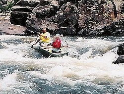
The Petawawa River is a popular whitewater river in Ontario, Canada.
A whitewater river is any river where its gradient and/or flow create rapids or whitewater turbulence. This list only focuses on rivers which are suitable for whitewater sports such as canoeing, kayaking, and rafting.
In the north, most rivers in India descend from the Himalayas, the highest mountains on Earth: cold glacial waters thunder down the rocks, bringing with them ample whitewater rapids to encounter. The water here is high volume and can be very violent in the early spring. Hence, extreme caution must be taken if one has not mastered paddling skills for rapids above class III. Caution should otherwise be exercised near the Tibetan border as this is area is a place of extreme political dispute, on land and on water.
Zanskar, a Grand Canyonesque experience. Class III-IV. Gradings, as on all rivers, subject to change depending on volume of water.
Brahmaputra River- This river begins in Tibet and winds its way towards Arunachal Pradesh, from whence it continues in a very steep gradient. Class V in high volume, but Class VI on some waterfalls that must be portaged. This area is a contested area between India and China and much paperwork is required to ride it.
Ganges: This river is thousands of miles long. It begins in the Himalayas and empties into the Bay of Bengal, shared with Bangladesh. Sadly, this river, very holy to Hindus, is very sick with pollution in its lower reaches, particularly near cities like Varanasi.[1] This is a big water river that varies through the whole gamut depending on location, class II-V+ rapids.[2]
Towards the south, all rivers originate from the Western Ghats. Most of them can only be paddled in the monsoon season (June–October), while some others can be paddled year-round as they are dependent on dam releases. Only a small percentage of the rivers have recorded descents, and there is a vast potential for first descents.
(Kampar River @ Itik, located in Gopeng Perak, Malaysia. Class I1-V)
(Selangor River, located in Kuala Kubu bahru, Selangor. Class II-V)
(Sungkai River, located in Sungkai, perak, Malaysia. Class I-V)
(Ulu Slim River, located at Slim Village, Perak, Malaysia. Class I-V)
(Bernam River, Located in Tanjung malim, Perak, Malaysia. Class I-III)
(Loh River, located in Ulu Dungun, Terengganu, Malaysia. Class II-VI)
(Singoh River, located in Grik, Perak, Malaysia. class II-VI)
(Sedim River, located in Kulim Kedah, Malaysia. Class II-V)
Philippines
Cagayan (de Oro) River, located in Cagayan de Oro City, Misamis Oriental, Philippines. Class II-III (upper section - class IV). Whitewater tributaries include:
Bubunaoan River, located in Cagayan de Oro City, Misamis Oriental and Bukidnon, Philippines. Class II-III
Tumalaong River, located in Lingating, Baungon, Bukidnon, Philippines. Class II-III
Kalawaig River, located in Talakag, Bukidnon, Philippines.
Tagoloan River, located in Tagoloan, Misamis Oriental, Philippines. Class I-II (upper Tagoloan - Class II-IV)
Malitbog River, located in Malitbog, Bukidnon, Philippines. Class II-III (creeking)
Agusan River, located in Agusan, Cagayan de Oro city, Philippines. Class II-III (creeking)
Jasaan (also known as Cabulig River) River, located in Jasaan, Misamis Oriental, Philippines. Class II in lower section, Class II-III in middle section.
Cabulaway River, located at Balingasag, Misamis Oriental, Philippines. Class I-III (creeking)
Europe
United Kingdom
Whitewater rivers in the UK are typically low volume and technical. In England and Wales rivers are typically less than 20m3/s, and some are run with less than 1m3/s (usually these involve skidding the kayak down steep rockslides and small waterfalls). In Scotland there are also a few bigger volume (up to about 50m3/s) rivers. Like many places in Europe, England, Scotland and Wales have been subject to centuries of rivers getting dammed, weired, or diverted in ways that suit agriculture or land development and the natural flow has been altered heavily in many regions; there are many orphan dams or sites intended for grist mills that no longer have any function but obstruct the water. Some areas of the island Great Britain occupies has enough gradient to create rapids and waterfalls, but unfortunately ages of damming prevents the full volume of water and snowmelt from reaching the lower reaches: Clywedog Dam holds back approximately 50,0000 megalitres of water alone on the River Severn, and Parliament granted weirs and locks to be placed upon that river multiple times during the 19th century, some of which are still used.[3] Scotland is famous for its rocky north, but many rivers have been dammed in Scotland over the course of the 20th century to create hydroelectric power, with the trend still continuing.[4]
Almost all runs in England and Wales need recent rain to be at a paddleable level, and many can only be run immediately after heavy rain. In Scotland, some bigger rivers can be run for weeks after rain although as with the rest of the country, most need recent wet weather. The paddling season is year-round but the rivers are more often runnable in winter (the wettest months of the year being December and January). Exceptions to this include rivers which have artificially maintained flows from reservoirs like the River Dee[5]. On these rivers, flow may increase in dry weather as more water is released. The Afon Tryweryn is one example in Wales.
Most runs offer only a few kilometres of whitewater; often several rivers can be run on a wet day. Some rivers consist of only a single rapid. Only a few rivers (such as the Findhorn and Spean in the Scottish Highlands) have more than a days' worth of paddling, and most of this tends to be grade III or less.
There are several sites off the west coast of Britain where strong tidal currents channeled between islands create big volume sections of whitewater. These include the Bitches in Pembrokeshire in Wales, and the Falls of Lora on the west coast of Scotland.
Legal access to whitewater is a big issue in England and Wales. The law is currently unclear, resulting in two schools of thought followed.
The first, followed by many anglers and the Anglers Association, states that rivers are almost all private and require access agreements to be set up with the riparian owners. This means that the public are only allowed access to a tiny proportion of the available whitewater, and often this is restricted to a few months or even a few days per year. This also limits commercial operations and the activities of clubs. Agreements rarely exist as there is no incentive for the owners of rivers to let anyone else use them.
Recently, legal research conducted by Rev Dr Douglas Caffyn,[6] claims to have identified a public right of access on all navigable rivers in England and Wales in Common Law. In law, a public right is a higher right than any private right, and so this outweighs the rights of the riparian owners in a court of law.
In Scotland, like most of the rest of the world, access to whitewater is legal and has never been illegal. It has been enshrined in law in the recent Scottish Land Reform act. The Right to Roam act in England explicitly excluded rivers. The British Canoe Union is running the Rivers Access Campaign to raise awareness and bring about changes in the law to permit public access to all inland rivers in England and Wales.
Alps
Whitewater rivers in the Alps are mainly medium volume glacier-fed rivers with long continuous rapids and few big drops.[citation needed] The season is short (two or three months in early summer when the snow and glaciers are melting) but the whitewater is reliable in this period. Tourists come from around Europe to kayak and raft–the most common centres are Briançon in the French Alps, the area around Landeck in Austria, and Bovec in Slovenia.[citation needed]
The best time to go rafting and kayaking in Greece is in Spring when the river flow and weather are ideal.
Arachthos River, Arta, Class 2–4
Kalaritikos River, Arta, Class 4
Mileopotamos River, Grevena, Class 3–4
Venetikos River, Grevena, Class 2–4
Pinios River - Vernezi Route, Larissa, Class 3–4
Aspropotamos River, Trikala, Class 3
Italy (Apennines)
Spring is the best time for rafting and kayaking in Southern Italy as the currents are stronger.
Lao River, Laino Borgo, Class 3–4
Montenegro
Rivers in Montenegro all come from high mountains close to the sea. They have natural riverbeds with very different sections from steep creeking to large volume. They have best water in spring, but some are runnable throughout the year.
Similar to its Swedish neighbour, Norwegian whitewater rivers are typically steep pool-drop rivers with many waterfalls, and are run mainly by experienced kayakers. There are also bigger (sometimes glacier-fed) rivers which are sometimes rafted. The season lasts all summer, although some rivers only run after recent rain. Norwegian waterfalls regularly feature on extreme kayaking videos.
Portugal
The best time for whitewater in Portugal is in Spring during the higher river flow.
Paiva River - Praia do Vau to Espiunca, Arouca, Class 3–4
Laboreiro River I - (Castro Laboreiro) Ameijoeira Bridge to Ribeiro de Baixo, class IV-V (X);
Laboreiro River II - (Castro Laboreiro) Ribeiro de Baixo to Olelas, Class IV-V (X);
Vez River I - Porta Cova (Sistelo) to Sistelo Bridge, Classe IV (V);
Russia
White water sport in Russia is quite popular,[citation needed] but the vast majority of people uses catamarans for these purposes. The best period for whitewater is May and July–August. Some rivers are possible to raft in June and September.
Katun river - Class IV. One of the most volumed river in the region.
Kumir, Korgon, Charysh rivers - Class IV. Normally, the trips include rafting down all three rivers.
Chuya river - Class V (VI for Mazhoiskiy kaskad). The right tributary of Katun river. There are regular competitions down Chuya on the Mazhoyskiy kaskad part - the canyon part of the river, which includes around 30 rapids, 10 of them are VI class.
Bolshaya Sumulta, Malaya Sumulta rivers - Class V. Malaya Sumulta flows into Bolshaya Sumulta which is the tributary of Katun.
Chulyshman river - Class V (VI). The middle and down part contain three rapids V class and two VI class. The upper part contains seven VI class rapids. There is an opportunity of rafting down upper Bashkaus and middle-down Chulyshman (Class V).
Bashkaus river - Class V (VI). The upper part has a number of IV class rapids and one V class. The down part is one of the most difficult places for white water containing 11 rapids VI class. The river flows in 35km canyon without any opportunity of evacuation by land.
Like the Alps, whitewater in the Pyrenees is best in early summer when the snow and glaciers are melting.
Ara River - Torla, Class 3–5
Gallego River - Murillo de Gallego, Class 3–4
Esera River - Campo (Huesca), Class 3–4
Noguera Pallaresa River - Llavorsi to Rialp, Sort, Class 3–4
Sweden
The Swedish whitewater rivers are mainly big water and is located in the middle and north parts of Sweden. One of the most spectacular rivers is Vindelaelven and particularly Trollforsarna III-VI, where one Euro cup competition was held in 2007.
The main information channel for Swedish white water is Forsguiden,
North America
Canada
Canada has a varied terrain that supports many kinds of environments, with the majority of whitewater found in three areas: the mountainous Rockies in Alberta, the smaller Eastern forests of Quebec, Ontario, and some of the Maritimes, and the volcanic influenced geology of British Columbia. This creates the conditions necessary for whitewater: gradient, volume, and pressure. Like its neighbor to the south, First Nations had used the river systems as personal highways and built dugout canoes to run rapids; later French Canadian fur trappers used the same technique to collect beaver pelts and form small settlements.
Canadian whitewater rivers are characterized by the dramatic difference between the high water spring run-off and the summer low water volume; the classification of rapids therefore changes from spring to summer. It also is highly subject to the change of seasons, where many places are frozen solid by October and, for example, runs that are ready in late May in the neighboring US Pacific Northwest are still too dangerous to attempt in British Columbia or too cold: the spring run-off of the glaciers has either not finished or the landscape is not fully thawed.
Most of the land in Canada is not privately owned and likewise neither are the rivers. Many places in which water thunders through the terrain are on land that is either protected or very remote, so knowledge of first aid and the local wildlife is paramount. As with the United States to the South, rattlesnakes, grizzly bears, black bears, mountain lions, wolves, and two members of the lynx family are very much active at the height of rafting and kayaking season, and they do use the water as a source of food and sustenance. On multi day excursions in The Northwest Territories, British Columbia, or Alberta it is extremely important to know or learn to coexist with the grizzly bears that live there; this is particularly true when it is salmon season. Caution should be used whenever camping in bear country, and learning how to properly store food or anything with a scent is paramount to avoiding conflict.
Niagara River The Canadian side of the river has the largest of the three set of waterfalls that make up Niagara Falls, all rated Class VI. Niagara Gorge squeezes a large volume that rivals the Congo River in size of the water in spite of being smaller in area.[citation needed] Many people have died from not respecting the water here, which is why one is very likely to get arrested for even attempting it.
The whitewater rivers in the Northwest Territories are remote and require access and egress by float plane or helicopter. Most are over or close to 300km in length from the put in to the take out, and therefore are multi-day expeditions.
The United States offers varied terrain and conditions through which rivers pass, everything from the deserts of the southwest to glacial peaks in Alaska to Appalachian creeks that thunder through the glades to even a few that run right through the downtown sections of small cities and isolated hamlets.
Legally, most rivers and creeks are not privately held. They are the property of the nation and its people and are overseen by individual state governments and a handful of federal government agencies in Washington, DC like the Department of the Interior, National Park Service, National Forest Service, and Bureau of Land Management. Dams may be held on a contract basis with the federal or state government, for example the energy company PG&E has dams in the Sierra Nevada range near Sacramento in California and this affects water volume. (Other entities like the Tennessee Valley Authority in the East have similar arrangements, and the water volume is lower than it should be naturally in the East in many sections of the Appalachians.) The Army Corps of Engineers and the operators of the dams themselves usually schedule releases in advance and this information is readily available to the public upon request.
Many whitewater rivers and creeks exist in rather rural or wild conditions when compared to parts of Europe and thus are located in places where animals can bite back or harm visitors, including children and dogs. (Some require a substantial hike through forest, desert, or mountains to reach the put in and cannot be reached by car at all.) In no particular order or regard to specific geography, they would include grizzly bears, black bears, moose, bull elk, porcupines, cougars, bobcats, more than 15 species of rattlesnakes on both sides of the Mississippi, scorpions, copperheads, water mocassins, and coral snakes. Beavers are sometimes extant on rivers but prefer to build in the calmer sections where there are only minor riffles and their dams are easily portaged or surmounted.
Eastern United States
There are several places in the East where the water roars, everything from big rivers like the Delaware River to creeks that dive over large waterfalls, many exceeding 30 feet (9.1m). In fact, there used to be more of them but over time some of these have been dammed or altered; the upper portions of the Mississippi River near St. Paul Minnesota, for example, used to have very large rapids and several waterfalls.[8] The Mississippi, the divide between East and West itself, used to be a much more wild and turbulent river[9] with more violent spots in its drainage area past Cairo Illinois with the Des Moines Rapids and the Sauk Rapids being either larger than today or undammed.
New England
The following are some of the rivers in New England that are popular.
Deerfield River, Vermont and Massachusetts, Class II-V. Navigable from spring until just before Halloween, when the water begins to freeze. First rafting companies set up here in the 1980s.
Hudson River, North Creek - Foreign visitors should be advised and warned that the name should not fool them: it is true that the Hudson empties in the tidal estuary where New York City sits. However, this section is over 200 miles away from New York City in heavily forested wilderness; this water is placid only in sections farther south and requires hiking to reach the put in in some cases; not to be attempted in the mistaken and dangerous belief the water is anything like it is near Manhattan. Class IV-V. Suitable for kayakers intermediate and above.
Middle Branch Oswegatchie River - Bryants Bridge and Sluice Falls sections, Class IV -V.
Lehigh River, White Haven to Jim Thorpe, Pennsylvania - a 24-mile (39km) run, through a gorge, Class III; in high water this is a Class 4 run. A very good choice for those learning to paddle when the water is at its normal level.
Potomac River, West Virginia/Maryland/Virginia, Class II-V+. This river begins in the Appalachian Mountains and runs to the sea, a distance of 367 miles (approx 591km.) This river forms the border between Northern Virginia and the District of Columbia. There are two major whitewater sections. The first is close to Harpers Ferry, West Virginia, class III. The second section is V to V+ and includes the Great Falls of the Potomac, just 12 miles (19km) from the center of Washington, D.C. Additionally, there are at least five major "forks" of the Potomac, with some reaching class III - IV (without waterfalls), mostly in West Virginia.
The Southeast is the section of the nation where the Appalachian Mountains have their highest peaks.[10] In most cases the size of the water is smaller than the West, however, some of the finest whitewater in the East is here, especially good for kayakers.[11]
Chattahoochee River, Columbus, Georgia- Urban whitewater, class I-V rapids. Short course of very turbulent rapids with unusually high water volume for a Southern river.[12]
Chattooga River, Georgia / South Carolina - sports long, challenging rapids, big drops, and thunderous power; this river can be a challenge for even experts; the Chattooga was one of the rivers used for the filming of the 1973 adventure movie, Deliverance. It is designated as a Wild and Scenic River.[13]
French Broad River, Asheville, North Carolina - featuring a long run of varying difficulty, from flatwater runnable in a canoe to class IV rapids near Hot Springs, North Carolina and the border with Tennessee. The main drawbacks are that the water tends to be muddy or polluted and it is a natural flow river.
Gauley River, Summersville, West Virginia - Nicknamed "The Beast of the East." Has huge rapids, especially at the "Fall Drawdown" (when the reservoir is drained) is a world-class ride; many of them listed as Class V; the Upper Gauley, from Summersville to Mason's Branch, is the tougher section; the Lower Gauley, from Koontz' Flume to Swiss, is still a Class-IV river with significant hazards; navigating the Upper and Lower Gauley in a single day is called "the Gauley Marathon," twenty-six miles of big rapids and paddling.
Green River, Asheville, North Carolina - the Green Narrows is the steepest "creek run" with regular activity in the Eastern U.S; with a gradient that reaches 600 feet/mile over one short section, The Narrows is a series of blind waterfalls and tight slots; regular, predictable releases from the Tuxedo Hydro Plant upstream draw paddlers on a regular basis.
James River, Richmond, Virginia - Urban whitewater; Class IV. Runs right through downtown Richmond, VA, the state capital.. Good for beginners in upper part and a decent river for practice for the more advanced. This river was named for James VI and I and was one of the first to ever be navigated by British settlers; much farther downriver the water becomes quieter and brackish and leads straight to the spot where the fort of Jamestown was built and the archaeological site still stands. Not far from Richmond, the Powhatan tribe built their capital, Werowocomoco, on an island in this river and chose it in part because of its considerable rapids.
Linville Gorge, western North Carolina - This runs right through Pisgah National Forest and has Class V rapids; it is a creek run suitable for kayakers and small canoes but it is too small for rafts. Approximately 17 miles long and not recommended at all for novices as it is one of the most difficult runs in the east. Very steep gorge walls make escape in an accident impossible. Deaths have occurred for those who overestimate their skills.
Nantahala River, Bryson City, North Carolina - a relatively gentle river, with the final rapid having the propensity to send paddlers in for a cold, exhilarating swim; suitable for beginners and families with younger children.
Ocoee River, Ducktown, Tennessee – Site of 1996 Olympic Slalom Course at the Ocoee Whitewater Center and already a river with natural whitewater. A very good river for both novices and more advanced paddlers. Gets its name from passiflora incarnata, the maypop, a very close relative of the commercial passionfruit that is a common edible garden plant in the South and was introduced as a source of food to settlers by tribes like the Cherokee. This plant is still found in thickets near the river.
Russell Fork, this class V river drops 150 feet (46m) per mile in the Russell Fork Gorge,[14] which has been described as a continuous 45-degree waterfall; it has dangerous rapids, even experienced paddlers have died in its many undercut rocks, and there have been many close calls; for the most experienced rafters and kayakers only.
In the western United States, the more noted rivers, such as the Grand Canyon have much greater water volume and therefore require a different set of paddling skills. Western rafters also navigate many small, low volume rivers, some with much steeper descents than eastern rivers; however, since the mountains are newer in the west, the hazard from undercut rocks, a problem in the east, is replaced by more frequent log jams precipitated by logging activities near the rivers.
The big-water rivers usually do not require the precision paddling of smaller rivers, but have larger rapids and longer wilderness trips due to the greater length and water flow of the big rivers. The smaller rivers and creeks boated by most rafters offer many one- or two-day trips with difficulty levels from I to VI.
In the West, some paddlers start on the American in California and work their way up to the Rogue and Illinois in Oregon, the Tuolumne (California), the Salmon in Idaho, the Snake, and then the big-water rivers like the Green and Colorado through the Grand Canyon (Arizona), the Fraser in British Columbia, and many Alaskan streams.
California has some of the most challenging whitewater runs in the United States as well as several rivers with sections that are safe for families with children who wish to go rafting. Several rivers in California are fed by the snowmelt of the Sierra Nevada mountain range as well as natural springs in high mountainous areas; some rivers flow directly through protected land and foreign visitors should be strongly warned that early spring runs can be very dangerous; the normal classification cranks up much higher turning some runs into death traps for even Olympic level whitewater enthusiasts. A primary example would be Cherry Creek, a class V-V+ river in normal conditions: this creek has had a number of fatalities to its name for unwary kayakers because the water cuts through high vertical walls of granite: there is no way out except down the river and certain sections cannot be portaged.[15][16][17] If the water volume gets too high, death is certain. It is for this reason most locals will not willingly even try to ride it before June.
Kings River[18][19]- Cuts through a very deep canyon. Overall class I-V rapids, depending on section as this river is quite large with many tributaries.[20] Portions of the river are part of Kings Canyon National Park and also flow through Sierra National Forest which abuts the national park directly; the most challenging whitewater is normally not accessible except by hiking or horseback. Portions of the river and its tributaries were used for the 1972 Slalom Olympic Trials.[20] Was designated a National Wild and Scenic River in 1987.[21]
Sacramento River[18][19]-This river is one of the most important rivers of Northern California. It begins in the Klamath Mountains and cuts right through downtown Sacramento, the state capital of California. It then turns west where it empties out near Oakland, a distance of over 400 miles. Although it has several sections that are heavily dammed for agriculture nearer the San Joaquin River Delta, others like the Upper Sacramento near Mount Shasta range class II-IV.
Tuolumne River[18][19] This river partially enters Yosemite National Park and once played a role in the now-gone Hetch Hetchy Valley. Its classification is I-V+. One section was not considered navigable until as late as 1983, and requires multiple portages of waterfalls that are too dangerous for kayakers in particular. This river requires overall that a rafter or kayaker knows how to swim, and many sections are in areas that are remote.[22]
Arkansas River - a big river, with many sections ranging from Class I to V, popular with kayakers and with commercial rafting companies. Numerous runs of all difficulty. Probably the most frequently run and one of the best rivers in Colorado.[citation needed]
Cache La Poudre River - Colorado's only federally designated Wild and Scenic River contains sections appropriate for every level of expertise including an easy Class II section, several Class III and Class-IV sections, as well as some Class V. There is a Class VI waterfall that is very dangerous because the last drop is unrunnable. The water pours off a slab into a 2-foot (0.61m)-wide crack and grinds anything that goes into it.
Colorado River-This river is the most famous whitewater river in the country, with sections in Arizona, Utah, Nevada (near Hoover Dam), and Colorado; it is also one of the longest rivers in the Western deserts and its overall classification ranges from I-V+. Gore Canyon is the first difficult section and should not be attempted by novices, Class IV-V, depending on the time of year and rainfall and this part is the upper section in Colorado. The section through the Grand Canyon and Grand Canyon National Park would include the Hance Rapids and overall the class of the rapids here are I-V, with the overall section being a IV. Utah's Cataract Canyon is third, with up to 1,400 m3/s volume running through the canyon as this section goes through Canyonlands National Park. Class III to V. Glen Canyon Dam is reliant on the releases from the dam that come seasonally, however this part can get up to V+. Trips down this river can take many days to complete, and full navigation, months.
Gunnison River: Grand Canyon National Park has a much lesser known sister to the northeast in Colorado: Black Canyon of the Gunnison National Park, created in 1999 and thus as of 2021one of the youngest of all national parks. The Gunnison River drops about 34 feet per mile (10.4 m/1.6km) in the canyon and thus has a steeper gradient than the portions of the Colorado that are normally rafted or kayaked. Rapids vary to class I to VI overall on the whole river and in the canyon itself the rapids get to V and up. Visitors must be highly skilled to raft the whole of the Black Canyon section.
Rogue River This river was one of about four that was selected for filming The River Wild. A good challenge for intermediate kayakers. Excellent fishing location and source is located close to Crater Lake.
This page is based on this Wikipedia article Text is available under the CC BY-SA 4.0 license; additional terms may apply. Images, videos and audio are available under their respective licenses.