The Tualatin River is a tributary of the Willamette River in Oregon in the United States. The river is about 83 miles (134 km) long, and it drains a fertile farming region called the Tualatin Valley southwest and west of Portland at the northwest corner of the Willamette Valley. There are approximately 500,000 people residing on 15 percent of the land in the river's watershed.

The Clackamas River is an approximately 83-mile (134 km) tributary of the Willamette River in northwestern Oregon, in the United States. Draining an area of about 940 square miles (2,435 km2), the Clackamas flows through mostly forested and rugged mountainous terrain in its upper reaches, and passes agricultural and urban areas in its lower third. The river rises in eastern Marion County, about 55 miles (89 km) east-southeast of Salem. The headwaters are on the slopes of Olallie Butte in the Mount Hood National Forest, about 10 miles (16 km) north of Mount Jefferson, at an elevation of 4,909 feet (1,496 m) in the Cascade Range. The Clackamas flows briefly north and then flows northwest through the mountains, passing through North Fork Reservoir and Estacada. It then emerges from the mountains southeast of Portland. It joins the Willamette near Oregon City and forms the boundary between Oregon City and Gladstone.

The Yamhill River is an 11-mile (18 km) tributary of the Willamette River, in the U.S. state of Oregon. Formed by the confluence of the South Yamhill River and the North Yamhill River about 3 miles (5 km) east of McMinnville, it drains part of the Northern Oregon Coast Range. The river meanders east past Dayton to join the Willamette River at its river mile (RM) 55 or river kilometer (RK) 89, south of Newberg.

The McKenzie River is a 90-mile (145 km) tributary of the Willamette River in western Oregon in the United States. It drains part of the Cascade Range east of Eugene and flows westward into the southernmost end of the Willamette Valley. It is named for Donald McKenzie, a Scottish Canadian fur trader who explored parts of the Pacific Northwest for the Pacific Fur Company in the early 19th century. As of the 21st century, six large dams have been built on the McKenzie and its tributaries.

The South Yamhill River is a tributary of the Yamhill River, approximately 60 miles (97 km) long, in northwest Oregon in the United States. It drains an area of the Northern Oregon Coast Range, as well as part of the Willamette Valley west of the Willamette River.
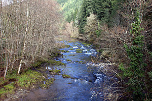
The Collawash River is a 12-mile (19 km) tributary of the Clackamas River in the U.S. state of Oregon. Formed by the confluence of Elk Lake Creek and the East Fork Collawash River in the Cascade Range, it flows generally north-northwest from source to mouth through the Mount Hood National Forest. The largest tributary of the upper Clackamas, it provides about a third of bigger river's low-flow volume. About 35 percent of its watershed of 150 square miles (390 km2) is protected as wilderness.
Abiqua Creek is a tributary of the Pudding River in the U.S. state of Oregon. The creek originates near Lookout Mountain in the foothills of the Cascade Range in the northwestern part of the state. It flows northwest for about 29 miles (47 km) to its confluence with the Pudding, about 2 miles (3.2 km) west of Silverton, in the Willamette Valley. About 20 miles (32 km) north of Silverton, the Pudding River meets the Molalla River, which meets the Willamette River less than 1 mile (1.6 km) later near Canby.

The Imnaha River is a 73.3-mile-long (118.0 km) tributary of the Snake River in the U.S. state of Oregon. Flowing generally east near the headwaters and then north through Wallowa County, the entire river is designated Wild and Scenic. It follows a geologic fault to the Snake River, and in addition to land in the Wallowa–Whitman National Forest and private land, its corridor includes parts of three special management areas: the Eagle Cap Wilderness, Hells Canyon National Recreation Area, and Hells Canyon Scenic Byway. The Imnaha flows by the unincorporated community of Imnaha, the only settlement along its course, and enters the Snake River roughly 4 miles (6 km) from the larger river's confluence with the Salmon River of Idaho and 192 miles (309 km) from its confluence with the Columbia River.

The Umatilla River is an 89-mile (143 km) tributary of the Columbia River in northern Umatilla County, Oregon, United States. Draining a basin of 2,450 square miles (6,300 km2), it enters the Columbia near the city of Umatilla in the northeastern part of the state. In downstream order, beginning at the headwaters, major tributaries of the Umatilla River are the North Fork Umatilla River and the South Fork Umatilla River, then Meacham, McKay, Birch, and Butter creeks.

Mill Creek is a 26-mile (42 km) tributary of the Willamette River that drains a 111-square-mile (290 km2) area of Marion County in the U.S. state of Oregon. Flowing generally west from its source south of Silver Falls State Park, it passes through the cities of Aumsville, Stayton, Sublimity, and Turner before emptying into the Willamette in Salem.

Gales Creek, is a tributary, 23.5 miles (37.8 km) long, of the Tualatin River in Washington County, Oregon, United States. The headwaters of Gales Creek are on the north side of the mountain Round Top in the Northern Oregon Coast Range. The community of Gales Creek, Oregon, is near the creek, which further downstream forms the southwest border of the city of Forest Grove.

Quartzville Creek is a 28-mile (45 km) tributary of the Middle Santiam River in Linn County in the U.S. state of Oregon. It is paralleled by the Quartzville Back Country Byway and used for recreation, including camping, fishing, hunting, kayaking, and gold panning. The lower 12 miles (19 km) of the creek, from the Willamette National Forest boundary to Green Peter Reservoir, was designated Wild and Scenic in 1988.

Ochoco Creek is a 30-mile (48 km) tributary of the Crooked River in the U.S. state of Oregon. Part of the drainage basin of the Columbia River, it arises in the Ochoco National Forest in Wheeler County and flows generally southwest and west for most of its length through Crook County to slightly northwest of Prineville.

The Rogue River in the U.S. state of Oregon begins at Boundary Springs on the border between Klamath and Douglas counties near the northern edge of Crater Lake National Park. The Rogue River flows generally west for 215 miles (346 km) from the Cascade Range through the Rogue River – Siskiyou National Forest and the Klamath Mountains to the Pacific Ocean at Gold Beach. Communities along its course include Union Creek, Prospect, Trail, Shady Cove, Gold Hill, and Rogue River, all in Jackson County; Grants Pass, and Galice in Josephine County, and Agness, Wedderburn and Gold Beach in Curry County. Significant tributaries include the South Fork Rogue River, Elk Creek, Bear Creek, the Applegate River, and the Illinois River. Arising at 5,320 feet (1,622 m) above sea level, the river loses more than 1 mile (1.6 km) in elevation by the time it reaches the Pacific.

The South Fork Rogue River is a 25-mile (40 km) tributary of the Rogue River in the U.S. state of Oregon. Rising in the Sky Lakes Wilderness in the Cascade Range, it flows generally northeast through the Rogue River – Siskiyou National Forest to meet the Rogue River downstream of Prospect and slightly upstream of Lost Creek Lake.

Mission Creek is a tributary, roughly 9 miles (14 km) long, of Champoeg Creek in Marion County in the U.S. state of Oregon. The creek arises southwest of St. Paul in the French Prairie region of the Willamette Valley and flows generally northeast to meet Champoeg Creek near Champoeg. The combined streams then flow less than 1 mile (1.6 km) before entering the Willamette River, 45 miles (72 km) from its confluence with the Columbia River.

The Willamette River is a 187-mile (301 km) tributary of the Columbia River in the U.S. state of Oregon. The upper tributaries of the Willamette originate in mountains south and southeast of the twin cities of Eugene and Springfield. Formed by the confluence of the Middle Fork Willamette River and Coast Fork Willamette River near Springfield, the main stem meanders generally north from source to mouth. The river's two most significant course deviations occur at Newberg, where the stream turns sharply east, and about 18 miles (29 km) downriver from Newberg, where it turns north again. Near its mouth, the river splits into two channels that flow around Sauvie Island. The main channel enters the Columbia about 101 miles (163 km) from the larger stream's mouth on the Pacific Ocean, and the smaller Multnomah Channel enters the Columbia about 14.5 miles (23.3 km) further downstream near St. Helens in Columbia County.

Blue River Reservoir is an artificial impoundment, about 6 miles (10 km) long, of the Blue River in Lane County in the U.S. state of Oregon. The reservoir is about 1 mile (1.6 km) north of Oregon Route 126 in the Willamette National Forest about 45 miles (72 km) east of Eugene.

The South Fork McKenzie River is a tributary, about 31 miles (50 km) long, of the McKenzie River in the U.S. state of Oregon. It begins at about 4,500 feet (1,400 m) above sea level near Mink Lake in the Three Sisters Wilderness of the Cascade Range. Flowing northwest within Lane County, it meets the McKenzie River about 60 miles (97 km) from the larger river's confluence with the Willamette River.
Smith River is a tributary of the McKenzie River in Linn County in the U.S. state of Oregon. It begins near Browder Ridge in the Cascade Range and flows generally south through the Willamette National Forest to meet the larger river at Trail Bridge Reservoir, about 82 miles (132 km) upstream of the McKenzie's mouth on the Willamette River.