Watauga River

Last updated

Watauga River
Watoga [1]
Watauga River-27527.jpg
The Watauga River near Valle Crucis, North Carolina
WataugaDoeRiverMap.png
Locator – overview
USA Tennessee relief location map.svg
Red pog.svg
Location of the mouth of Watauga River in Tennessee
EtymologyNative American
Location
Country United States
States North Carolina, Tennessee
Counties Avery NC, Watauga NC, Johnson TN, Carter TN, Sullivan TN, Washington TN
Physical characteristics
SourceLinville Gap [2]
  location Sugar Mountain, North Carolina
  coordinates 36°07′25″N81°50′07″W / 36.12361°N 81.83528°W / 36.12361; -81.83528 [3]
  elevation4,051 ft (1,235 m)
Mouth Holston River, South Fork
  location
Gray, Tennessee
  coordinates
36°26′50″N82°25′15″W / 36.44722°N 82.42083°W / 36.44722; -82.42083 [3]
  elevation
1,352 ft (412 m) [3]
Length78.5 mi (126.3 km)
Basin size867.849 sq mi (2,247.72 km2)
Basin features
ProgressionWatauga → HolstonTennesseeOhioMississippiGulf of Mexico

The Watauga River ( /wəˈtɔːɡə/ ) [4] is a large stream of western North Carolina and East Tennessee. It is 78.5 miles (126.3 km) long with its headwaters in Linville Gap to the South Fork Holston River at Boone Lake.

Contents

Course

The Watauga River rises from a spring located south to the base of Peak Mountain at Linville Gap in Avery County, North Carolina. The spring emanates from the western side of the Tennessee Valley Divide, which is, at this location, congruent with the Eastern Continental Divide. On the other side of the divide at Linville Gap are the headwaters of the Linville River in the Upper Catawba watershed. Waters of the Linville River eventually reach the Atlantic Ocean, whereas waters of the Watauga River reach the Gulf of Mexico; hence the Eastern Continental Divide. The river then flows across Watauga County, North Carolina, crossing the Tennessee state line (River Mile (RM) 55.1) at Johnson County, then into Carter County, Tennessee and ends at its confluence with the Holston River's South Fork (RM 0) on the Washington/Sullivan County border.

Impoundment

After crossing into Johnson County, the Watauga River is first impounded by the Tennessee Valley Authority (TVA) Watauga Dam, creating the 6,430-acre (2,600 ha) Watauga Lake. [5] This impoundment receives two important tributaries: the Elk River and Roan Creek. Watauga Lake is bridged by Tennessee State Route 67 over Butler Memorial Bridge just as the watercourse enters Carter County. The Appalachian Trail crosses the river on Watauga Dam.

Nearly 3 miles below Watauga Dam, on the Horseshoe section of the Watauga River, is the TVA Wilbur Dam, which forms a much smaller but very deep reservoir known as Wilbur Lake. TVA releases approximately 130 cubic feet per second (3.7 m3/s) of discharged water back into the Watauga River during the summer months. [6] Below Wilbur Dam the river flows generally north and then west into Carter County where it forms the northern limits of Elizabethton, where the Watauga then receives the Doe River. Farther downstream on the Watauga River at the boundary between Carter County and Washington County is the old TVA Watauga Steam Plant.

A portion of the boundary line between Washington County and Sullivan County is formed by the Watauga River. Boone Dam is located below the slack water confluence of both South Fork Holston River and the downstream end (mouth) of the Watauga River. The distance afloat between the TVA Watauga Reservoir and Boone Lake is approximately 20.6 miles (33.2 km). [7]

History

The true origin of the name of the Watauga River is probably lost to antiquity. Most documents agree that the name is of Native American origin, though which nation, tribe or language it descends from, and its meaning, are in question. Early Tennessee historian John Haywood states in his "The Civil and Political History of the State of Tennessee" published in 1823 that the "Watauga signifies the River of Islands, or the Island River. The Holston River was known to the Cherokees by the name of Watauga.". [8] Pre-Civil War maps of Tennessee show that the river designated as the Holston River extended west of Knoxville, meeting with the Clinch River near Kingston and well past the present-day beginning of the Tennessee River (east of Knoxville) at the confluence of both the Holston River and the French Broad River. [9]

A North Carolina State University web page (the Watauga Medal) says the word "Watauga" is a Native-American word meaning "the land beyond". [10] Local references say the name means "beautiful river" or "beautiful water". There were at least two Native American villages so named, including one at present-day Elizabethton, which became known as "Watauga Old Fields", referring to former Native American residents. It was first explored by Daniel Boone and James Robertson in 1759. A historic Cherokee town known as Watauga was located along the Little Tennessee River near present-day Franklin, North Carolina, in their homelands.

The original settlers of Nashville, Tennessee, set out west from the Watauga River area, called the Watauga Association, during the American Revolution. They realized that the British Proclamation of 1763, forbidding colonial settlement west of the Blue Ridge Mountains in order to protect Native American territories, was essentially unenforceable. [11]

The Watauga River below the TVA Wilbur Dam TVA Wilbur Dam.jpg
The Watauga River below the TVA Wilbur Dam

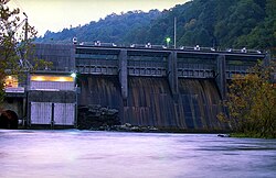
Wilbur Dam is the site of first hydroelectric dam constructed in Tennessee (beginning in 1909), going online with power production and distribution in 1912. [12] Wilbur Dam was constructed on the Watauga River by the former Tennessee Electric Power Company, a privately owned utility purchased by the TVA in the late 1930s. [12] Elizabethton acquired the moniker "City of Power" because of its early access to hydro-generated electricity from Wilbur Dam. [13]

The Watauga river is home to the endangered green floater mussel ( Lasmigona subviridis ). [14]

Recreation

Whitewater rafting, kayaking, canoeing, fly fishing, and angling with fishing reels are all popular recreation activities pursued on the Watauga River. Rainbow trout, brown trout, and striped bass are all caught in the Watauga River.

Whitewater

Kayaker at the Bee Cliff Rapids paddling inside "The Big Hole" KayakerTheBigHole.jpg
Kayaker at the Bee Cliff Rapids paddling inside "The Big Hole"

The Watauga River downstream of the TVA dams draws commercial rafting outfitters from both northeast Tennessee and western North Carolina during the summer months and commercial fishing guides throughout the year. The picturesque Class II+ Bee Cliff Rapids on the Watauga River (also referred to the "Anaconda Rapids" by some North Carolina-based rafting companies) are found downstream between Wilbur Dam and the Siam Bridge, southeast of Elizabethton. [15]

Raft guide, Trey Boggs, plunging whitewater rafters downstream through "The Big Hole" in the Bee Cliff Rapids WataugaTheBigHole.jpg
Raft guide, Trey Boggs, plunging whitewater rafters downstream through "The Big Hole" in the Bee Cliff Rapids

For commercial whitewater rafting and kayaking on the Watauga River, the most popular Carter County "put-in" is immediately downstream of the TVA Wilbur Dam, and the most popular "take-out" is 2 to 2½ hours downstream (depending upon the volume of the reservoir release and other factors) at the Blackbottom riverside portion of the city linear trail park in Elizabethton. The distance afloat for paddlers from the put-in at Wilbur Dam to the Blackbottom take-out is approximately seven miles, with landmarks along the Watauga River providing a good estimate of time and distance traveled.

Wilbur Dam to Bee Cliff Rapids~15 minutes
Wilbur Dam to Siam Bridge~30 minutes
Wilbur Dam to Hunter Bridge (TWRA put-in/take out)~60 minutes
Wilbur Dam to Gilbert Peters Bridge at US 19-E in Elizabethton~90 minutes
Wilbur Dam to Bristol Bridge in Elizabethton~120 minutes

The Watauga River also has a section of Class IV-V whitewater popular with expert kayakers, upstream of Watauga Lake in North Carolina. [16] This section requires significant rainfall to bring it up to runnable levels. It features continuous steep boulder bed rapids dropping up to 150 feet per mile (28 m/km), and several falls and ledges only runnable by expert paddlers.

TVA recreation areas

The Tennessee Valley Authority maintains a self-service public campground below Watauga Dam. Amenities and recreational opportunities at the TVA Watauga Dam Tailwater Campground include 29 camp sites with electric hookups, rest rooms with heated showers and flush toilets, dump station, public phone, picnic tables and grills, canoe access, boat ramps above and below dam, lake and river fishing, hiking trail, walking trail, wildlife viewing area, and birdwatching. [17]

Influence of weather

The TVA regulates flow of the Watauga River by scheduling the release of deep, impounded reservoir waters from behind both the Watauga Dam and Wilbur Dam. As a result, the summer temperature of the Watauga River is approximately 52–53°F(11–12 °C) downstream of the dams. The Watauga River is generally comfortable for kayaking, canoeing, and rafting during the summer months, but care must be taken to prevent hypothermia by prolonged exposure to the cold river water.

As TVA also guarantees a minimum release schedule during the summer season for riverine recreation below Wilbur Dam, the Watauga River will draw commercial whitewater rafting companies from distant rivers—such as the Nolichucky River running through Erwin, Tennessee in Unicoi County [18] —when lack of adequate summer rain fall will not allow for rafting trips on these naturally flowing rivers during seasonal droughts.

Climate of Watauga River at Elizabethton, Tennessee
MonthJanFebMarAprMayJunJulAugSepOctNovDecAnnual
Avg °F(°C)34.0°F1.1°C37.4°F3.0°C47.2°F8.4°C55.2°F12.9°C63.4°F17.4°C71.1°F21.7°C74.4°F23.6°C73.6°F23.1°C67.9°F19.9°C56.7°F13.7°C47.0°F8.3°C38.2°F3.4°C55.5°F13.1°C
Avg high °F(°C)43.7°F6.5°C48.0°F8.9°C58.9°F14.9°C67.4°F19.7°C75.2°F24.0°C82.2°F27.9°C84.6°F29.2°C84.1°F28.9°C79.1°F26.2°C69.1°F20.6°C58.2°F14.6°C48.1°F8.9°C66.6°F19.2°C
Avg low °F(°C)24.3°F
-4.3°C
26.8°F
-2.9°C
35.4°F1.9°C43.0°F6.1°C51.6°F10.9°C59.9°F15.5°C64.1°F17.8°C63.1°F17.3°C56.6°F13.7°C44.2°F6.8°C35.9°F2.2°C28.2°F-2.1°C44.4°F6.9°C
Rain (inches)3.2 in. 3.4 in. 3.7 in. 3.3 in. 3.8 in. 3.5 in. 4.3 in. 3.2 in. 3.3 in. 2.6 in. 2.9 in. 3.4 in. 40.7 in.
Snow (inches)5.2 in. 4.2 in. 2.3 in. 0.4 in. 0.05 in. 0.05 in. 0.0 in. 0.0 in. 0.05 in. 0.0 in. 0.9 in. 2.6 in. 15.6 in.
Sources for Watauga River at Elizabethton (Bristol-Johnson City, Tennessee) climate statistics:
climate-zone.com'
[19]

See also

Notes and references

  1. "Virginia, North and South Carolina, Georgia, and Florida" (Map). A Map of the British Empire in America with the French and Spanish Settlements adjacent thereto. 1:2,000,000. Willm. Henry Toms & R. W. Seale. 1733. Retrieved February 14, 2015.
  2. "Linville Gap". Geographic Names Information System . United States Geological Survey, United States Department of the Interior. June 17, 1980. Retrieved December 28, 2020.
  3. 1 2 3 "Watauga River". Geographic Names Information System . United States Geological Survey, United States Department of the Interior. May 19, 1980. Retrieved December 28, 2020.
  4. "Talk Like a Tar Heel". The Louis Round Wilson Library Special Collections. UNC University Libraries. Retrieved November 16, 2019.
  5. "Watauga Reservoir – General Information". tnfish.org. Tennessee Wildlife Resources Agency. January 2008. Archived from the original on May 17, 2008. Retrieved July 13, 2017.{{cite web}}: CS1 maint: unfit URL (link)
  6. "Wilbur". tva.gov. Tennessee Valley Authority. Retrieved November 16, 2019.
  7. "Watauga – Watauga Reservoir to Boone Lake". American Whitewater. Retrieved July 13, 2017.
  8. The Civil and Political History of the State of Tennessee : From Its Earliest Settlement Up to the Year 1796 ; Including the Boundaries of the State https://archive.org/details/civilpoliticalhi00inhayw/page/29/mode/1up?q=Watauga
  9. https://www.tngenweb.org/maps/tannersm.jpg Tennessee, 1834 – Extracted from Henry Schenck Tanner’s U. S. Map.
  10. "The Watauga Medal" . North Carolina State University.
  11. Mary Beth Norton; Carol Sheriff; David W. Blight; Howard Chudacoff; Fredrik Logevall (2011). A People and a Nation: A History of the United States, Volume I: To 1877. Cengage Learning. pp. 144–5. ISBN   978-0-495-91589-8 . Retrieved March 17, 2015.
  12. 1 2 "Wilbur Dam". tva.gov. Tennessee Valley Authority. Retrieved November 16, 2019.
  13. "Eliz. Electric". elizabethton.org. City of Elizabethton, TN. Retrieved July 13, 2017.
  14. "Green Floater". North Carolina Wildlife Resources Commission. Retrieved November 16, 2019.
  15. U.S. Geological Survey Geographic Names Information System: Watauga River
  16. "Guys Ford Bridge to Watauga Lake (Watauga Gorge)". American Whitewater. Retrieved July 13, 2017.
  17. "Camping". tva.gov. Tennessee Valley Authority. Retrieved November 16, 2019.
  18. Thompson, John; Hicks, Brad (January 16, 2013). "Area counties contend with high water". Johnson City Press. Retrieved July 13, 2017.
  19. www.climate-zone.com

Related Research Articles

<span class="mw-page-title-main">Carter County, Tennessee</span> County in Tennessee, United States

Carter County is a county located in the U.S. state of Tennessee. As of the 2020 census, the population was 56,356. Its county seat is Elizabethton. The county is named in honor of Landon Carter (1760-1800), an early settler active in the "Lost State of Franklin" 1784-1788 secession from the State of North Carolina. Carter County is part of the Johnson City, TN Metropolitan Statistical Area, which is a component of the Johnson City–Kingsport–Bristol, TN-VA Combined Statistical Area, located in northeastern Tennessee.

<span class="mw-page-title-main">Elizabethton, Tennessee</span> City in Tennessee, United States

Elizabethton is a city in, and the county seat of Carter County, Tennessee, United States. Elizabethton is the historical site of the first independent American government located west of both the Eastern Continental Divide and the original Thirteen Colonies.

<span class="mw-page-title-main">Toccoa/Ocoee River</span> River in Georgia and Tennessee in the United States

The Toccoa River and Ocoee River are the names in use for a single 93-mile-long (150 km) river that flows northwestward through the southern Appalachian Mountains of the southeastern United States. It is a tributary of the Hiwassee River, which it joins in Polk County, Tennessee, near the town of Benton. Three power generating dams are operated along it.

<span class="mw-page-title-main">Holston River</span> River in Tennessee, United States

The Holston River is a 136-mile (219 km) river that flows from Kingsport, Tennessee, to Knoxville, Tennessee. Along with its three major forks, it comprises a major river system that drains much of northeastern Tennessee, southwestern Virginia, and northwestern North Carolina. The Holston's confluence with the French Broad River at Knoxville marks the beginning of the Tennessee River.

<span class="mw-page-title-main">Doe River</span> Tributary of the Watauga River in northeast Tennessee, United States

The Doe River is a tributary of the Watauga River in northeast Tennessee in the United States. The river forms in Carter County near the North Carolina line, just south of Roan Mountain State Park, and flows to Elizabethton.

<span class="mw-page-title-main">Nolichucky River</span> River in the Eastern United States

The Nolichucky River is a 115-mile (185 km) river that flows through western North Carolina and East Tennessee in the southeastern United States. Traversing the Pisgah National Forest and the Cherokee National Forest in the Blue Ridge Mountains, the river's watershed includes some of the highest mountains in the Appalachians, including Mount Mitchell in North Carolina, the highest point in the eastern United States. The river is a tributary of the French Broad River and is impounded by Nolichucky Dam near Greeneville, Tennessee.

<span class="mw-page-title-main">Sycamore Shoals</span> River rapids along the Watauga River in Elizabethton, Tennessee, US

The Sycamore Shoals of the Watauga River, usually shortened to Sycamore Shoals, is a rocky stretch of river rapids along the Watauga River in Elizabethton, Tennessee. Archeological excavations have found Native Americans lived near the shoals since prehistoric times, and Cherokees gathered there. As Europeans began settling the Trans-Appalachian frontier, the shoals proved strategic militarily, as well as shaped the economies of Tennessee and Kentucky. Today, the shoals are protected as a National Historic Landmark and are maintained as part of Sycamore Shoals State Historic Park.

<span class="mw-page-title-main">Watauga Lake</span> Reservoir in Tennessee, United States

Watauga Lake, located east of Elizabethton, Tennessee, is the local name of the Watauga Reservoir created by the Tennessee Valley Authority (TVA) with the 1948 completion of the TVA Watauga Dam.

<span class="mw-page-title-main">Bee Cliff (Tennessee)</span>

The Bee Cliff is a prominent northeast Tennessee geological limestone feature with high caves that overlooks the Watauga River and the Siam community of Carter County, Tennessee.

Boone Lake is a reservoir in Sullivan and Washington counties in northeastern Tennessee, formed by the impoundment of the South Fork Holston River and Watauga River behind Boone Dam. Boone Reservoir’s 4,400 acres extend along the South Fork Holston River forming two river extensions. According to TVA, “at maximum pool level, one arm of the lake extends about 16 miles up the South Fork Holston River, and the other extends approximately 15 miles up the Watauga River".

<span class="mw-page-title-main">Douglas Lake</span> Man-made reservoir in Tennessee, United States

Douglas Lake, also called Douglas Reservoir, is a reservoir created by an impoundment of the French Broad River in Eastern Tennessee. This lake is located only a few miles from the Pigeon Forge/Gatlinburg area, and also the Great Smoky Mountains National Park.

<span class="mw-page-title-main">Cherokee Lake</span> Artificial reservoir in East Tennessee, United States

Cherokee Lake, also known as Cherokee Reservoir, is an artificial reservoir in the U.S. state of Tennessee formed by the impoundment of the Holston River behind Cherokee Dam.

<span class="mw-page-title-main">Tennessee State Route 67</span> Highway in Tennessee

State Route 67 is a state-maintained highway in northeastern Tennessee, including a four-lane divided highway segments in both Washington County and Carter County, and part of a significant two-lane segment passing over the Butler Bridge some 80 feet (24 m) above the TVA Watauga Reservoir near Butler in Johnson County, Tennessee.

<span class="mw-page-title-main">Watauga Dam</span> Dam in Tennessee, United States

Watauga Dam is a hydroelectric and flood control dam on the Watauga River in Carter County, in the U.S. state of Tennessee. It is owned and operated by the Tennessee Valley Authority, which built the dam in the 1940s as part of efforts to control flooding in the Tennessee River watershed. At 318 feet (97 m), Watauga is the second-highest dam in the TVA river and reservoir system, and at the time of its completion was one of the highest earth-and-rock dams in the United States. The dam impounds the TVA Watauga Reservoir of 6,430 acres (2,600 ha), and its tailwaters feed into Wilbur Lake.

<span class="mw-page-title-main">South Holston Dam</span> Dam in Tennessee, United States

South Holston Dam is a hydroelectric and flood control dam on the South Fork Holston River in Sullivan County, in the U.S. state of Tennessee. It is the uppermost of three dams on the South Fork Holston owned and operated by the Tennessee Valley Authority, which built the dam in the 1940s as part of efforts to control flooding in the Tennessee River watershed. On October 21, 1950 the valve gate closed and water began backing up to create South Holston Reservoir. Work began on the dam in December 1941, but in November 1942, the War Production Board requested that the operation be suspended because of a shortage of critical materials. Work did not resume until July 1, 1947. The dam now impounds the South Holston Lake of 7,550 acres (3,060 ha), which extends northeastward across the Tennessee-Virginia state line.

<span class="mw-page-title-main">Wilbur Dam</span> Dam in Tennessee, United States

Wilbur Dam is a hydroelectric dam on the Watauga River in Carter County, in the U.S. state of Tennessee. It is one of two dams on the river owned and operated by the Tennessee Valley Authority. The dam impounds Wilbur Lake, which extends for about 3 miles (4.8 km) up the Watauga to the base of Watauga Dam. Wilbur Dam was completed in 1912 making it the second oldest dam in the TVA system behind Ocoee Dam No. 1. Wilbur Dam was one of the first major hydroelectric projects in Tennessee, and remains one of the oldest dams in the TVA system.

<span class="mw-page-title-main">Boone Dam</span> Dam in Tennessee, United States

Boone Dam is a hydroelectric and flood control dam on the South Fork Holston River on the border between Sullivan County and Washington County in the U.S. state of Tennessee. It is one of three dams on the South Fork Holston owned and operated by the Tennessee Valley Authority, which built the dam in the early 1950s as part of greater efforts to control flooding in the Tennessee River watershed. The dam impounds the 4,500-acre (1,800 ha) Boone Lake, and its tailwaters are part of Fort Patrick Henry Lake. The dam and associated infrastructure were listed on the National Register of Historic Places in 2017.

<span class="mw-page-title-main">Fort Patrick Henry Dam</span> Dam in Tennessee, United States

Fort Patrick Henry Dam is a hydroelectric dam on the South Fork Holston River within the city of Kingsport, in Sullivan County in the U.S. state of Tennessee. It is the lowermost of three dams on the South Fork Holston owned and operated by the Tennessee Valley Authority, which built the dam in the early 1950s to take advantage of the hydroelectric potential created by the regulation of river flow with the completion of Watauga Dam, South Holston Dam, and Boone Dam further upstream in preceding years. The dam impounds the 872-acre (353 ha) Fort Patrick Henry Lake. While originally built for hydroelectric generation, the dam now plays an important role in the regulation of water flow and water temperature for the John Sevier Fossil Plant and other industrial plants downstream. The dam and associated infrastructure were listed on the National Register of Historic Places in 2017.