McDowell County is a county located in the U.S. state of North Carolina. As of the 2020 census, the population was 44,578. Its county seat is Marion.

Gaston County is a county in the U.S. state of North Carolina. As of the 2020 census, the population was 227,943. The county seat is Gastonia. Dallas served as the original county seat from 1846 until 1911.

Catawba County is a county in the U.S. state of North Carolina. As of the 2020 census, the population was 160,610. Its county seat is Newton, and its largest city is Hickory.

Burke County is a county located in the U.S. state of North Carolina. As of the 2020 census, its population was 87,570. Its county seat is Morganton.

Marion is a city in and the county seat of McDowell County, North Carolina, United States. Founded in 1844, the city was named in honor of Brigadier General Francis Marion, the American Revolutionary War Hero whose talent in guerrilla warfare earned him the name "Swamp Fox". Marion's Main Street Historic District is listed on the National Register of Historic Places. The population was 7,717 at the 2020 Census.

The Blue Ridge Parkway is a National Parkway and All-American Road in the United States, noted for its scenic beauty. The parkway, which is America's longest linear park, runs for 469 miles (755 km) through 29 Virginia and North Carolina counties, linking Shenandoah National Park to Great Smoky Mountains National Park. It runs mostly along the spine of the Blue Ridge, a major mountain chain that is part of the Appalachian Mountains. Its southern terminus is at U.S. Route 441 (US 441) on the boundary between Great Smoky Mountains National Park and the Qualla Boundary of the Eastern Band of Cherokee Indians in North Carolina, from which it travels north to Shenandoah National Park in Virginia. The roadway continues through Shenandoah as Skyline Drive, a similar scenic road which is managed by a different National Park Service unit. Both Skyline Drive and the Virginia portion of the Blue Ridge Parkway are part of Virginia State Route 48 (SR 48), though this designation is not signed.

Occoneechee Mountain State Natural Area is a North Carolina state park in Orange County, North Carolina in the United States. Located adjacent to the town of Hillsborough, it covers 221 acres (0.89 km2) and includes Occoneechee Mountain, the highest point (867 ft) in Orange County and a settlement of the Occaneechi tribe.

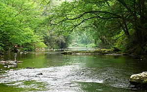
South Mountains State Park is a North Carolina state park in Burke County, North Carolina in the United States. Located near Connellys Springs, North Carolina, it covers 20,949 acres (84.78 km2) and includes part of the South Mountains, a branch of the Blue Ridge Mountains. High Shoals Falls is the park's most visited feature.

The Catawba River is a major river located in the Southeastern United States. It originates in Western North Carolina and flows into South Carolina, where it later becomes known as the Wateree River. The river is approximately 220 miles (350 km) long. It rises in the Appalachian Mountains and drains into the Piedmont, where it has been impounded through a series of reservoirs for flood control and generation of hydroelectricity. The river is named after the Catawba tribe of Native Americans, which lives on its banks. In their language, they call themselves "yeh is-WAH h’reh", meaning "people of the river."

The Watauga River is a large stream of western North Carolina and East Tennessee. It is 78.5 miles (126.3 km) long with its headwaters in Linville Gap to the South Fork Holston River at Boone Lake.

The Mountains-to-Sea State Trail (MST) is a long-distance trail in the USA for hiking and backpacking, that traverses North Carolina from the Great Smoky Mountains to the Outer Banks. Its western endpoint is at Clingman's Dome, where it connects to the Appalachian Trail in the Great Smoky Mountains National Park. Its eastern endpoint is in Jockey's Ridge State Park on the tallest sand dune on the east coast. The trail is envisioned as a scenic backbone of an interconnected trail system spanning the state. As such, its route attempts to connect as many trail systems and natural scenic areas as practicable. A little over half of the trail is complete in multiple segments across the state.


Western North Carolina is the region of North Carolina which includes the Appalachian Mountains; it is often known geographically as the state's Mountain Region. It contains the highest mountains in the Eastern United States, with 125 peaks rising to over 5,000 feet in elevation. Mount Mitchell at 6,684 feet, is the highest peak of the Appalachian Mountains and mainland eastern North America. The population of the region, as measured by the 2010 U.S. Census, is 1,473,241, which is approximately 15% of North Carolina's total population.
The Horsepasture River is an 18.1-mile-long (29.1 km) National Wild and Scenic river in the U.S. states of North Carolina and South Carolina. The river rises in Jackson County, North Carolina, and flows through the Jocassee Gorges area and ends at Lake Jocassee in South Carolina. Some of the land over which the river flows is part of the Pisgah National Forest, making it accessible to the public.

Lake James is a large reservoir in the mountains of Western North Carolina which straddles the border between Burke and McDowell Counties. It is named for tobacco tycoon and benefactor of Duke University James Buchanan Duke. The lake, with surface elevation of 1200 ft, lies behind a series of 4 earthen dams. It was created by Duke Power between 1916 and 1923 as a hydro-electric project. It still generates power today and is the uppermost lake on the Catawba River system.

Linville Falls is a waterfall located in the Blue Ridge Mountains of North Carolina in the United States. The falls move in several distinct steps, beginning in a twin set of upper falls, moving down a small gorge, and culminating in a high-volume 45-foot (14 m) drop.

Linville is an unincorporated community and census-designated place (CDP) in Avery County, North Carolina, United States. It was first listed as a CDP in the 2020 census with a population of 283. Centered just south of US 221 and NC 105, the community is known as a summer mountain resort and host of the Grandfather Mountain Highland Games, the largest modern Highland games events in North Carolina.
Hemlock Bluffs Nature Preserve is a joint project between the North Carolina state park system and Cary, Wake County, North Carolina in the United States. Located in Cary, it covers approximately 140-acre (0.57 km2) in the Research Triangle region of the state. The state owns 97-acre (0.39 km2) of the preserve, known as Hemlock Bluffs State Natural Area. The Town of Cary owns approximately 42-acre (0.17 km2) of the preserve, and the town leases the state's land for management. The preserve protects a population of Eastern Hemlock trees and other vegetation more typically found further west, in the Appalachian Mountains. The tall, north-facing bluffs of Swift Creek provide conditions similar enough to the mountains to have allowed the plant communities to have survived there since the last ice age.
The Wilderness Gateway State Trail is a unit of the North Carolina state park system in Burke, Catawba, McDowell and Rutherford Counties, North Carolina in the United States. The State Trail is planned as a hiking trail connecting the Town of Valdese, the City of Hickory, the Overmountain Victory National Historic Trail, South Mountains State Park and Chimney Rock State Park The trail is a collaboration between local governments and the state, with development coordinated by the North Carolina Division of Parks and Recreation (NCDPR).