Cougar Mountain Regional Wildland Park is a regional park in King County, Washington, near the towns of Bellevue and Issaquah. The park was established in June 1983 to protect the central core of Cougar Mountain, the park covers 3,115 acres (12.61 km2) with 38 miles (61 km) of hiking trails and 12 miles (19 km) of equestrian trails.

Mount Pisgah is a mountain in the Appalachian Mountain Range and part of the Blue Ridge Mountains of North Carolina, United States. The mountain's height is 5,721 feet above sea level, and it sits approximately 15 miles southwest of Asheville, near the crossing of the boundaries of Buncombe, Haywood, Henderson and Transylvania counties. It is located on the border of Buncombe and Haywood counties, close to the point where Henderson and Transylvania meet them, but not actually within the latter two counties. The mountain is easily accessible via a hiking trail from the Blue Ridge Parkway, near the Pisgah Inn.

The Mountains-to-Sea State Trail (MST) is a long-distance trail for hiking and backpacking, that traverses North Carolina from the Great Smoky Mountains to the Outer Banks. The trail's western endpoint is at Clingman's Dome, where it connects to the Appalachian Trail in the Great Smoky Mountains National Park. Its eastern endpoint is in Jockey's Ridge State Park on the tallest sand dune on the east coast. The trail is envisioned as a scenic backbone of an interconnected trail system spanning the state. As such, the trail's route attempts to connect as many trail systems and natural scenic areas as practicable. A little over half of the trail is complete in multiple segments across the state.
Linville Falls is a waterfall located in the Blue Ridge Mountains of North Carolina in the United States. The falls move in several distinct steps, beginning in a twin set of upper falls, moving down a small gorge, and culminating in a high-volume 45-foot (14 m) drop. It is named for the Linville River, which goes over the falls. Linville Falls has the highest volume of any waterfall on the Northern Edge of the Blue Ridge Mountains.

Douglas Falls are a 60-foot waterfall located in Buncombe County, North Carolina, United States. It is on a tributary of Waterfall Creek which flows into the Ivy River, and it is within the Big Ivy section of the Pisgah National Forest. The stream flows off the slope of Craggy Pinnacle, starting just below the Blue Ridge Parkway. It is surrounded by a forest of very large Eastern Hemlock trees, which are dead following attack by the Hemlock Wooly Adelgid. Visitors should be very careful when visiting this falls, as the dead Hemlocks will start to decay and fall within the next few years.

Cascade Falls, also called "The Cascades", is a waterfall located at E. B. Jeffress Park on the Blue Ridge Parkway in the Blue Ridge Mountains of North Carolina, United States.

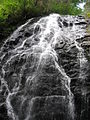
Setrock Creek Falls is a waterfall in the Pisgah National Forest, in North Carolina.
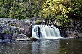
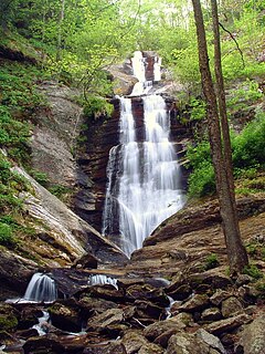
Roaring Fork Falls, also called Roaring Creek Falls, is a waterfall in the Pisgah National Forest, in North Carolina.

Bonita Falls are a set of waterfalls in the San Bernardino National Forest, formed by Bonita Creek, that is said to be 370 or 400 feet in height, but possibly up to 495 feet high because of two undocumented drops in the canyon above. It is the second tallest in the national forest, being surpassed only by 500-foot Big Falls. These two waterfalls are reputably the tallest in southern California.

Spahats Creek Falls, also called Spahats Falls, is a waterfall on Spahats Creek within Wells Gray Provincial Park of British Columbia, Canada. Common references place the falls at around 60 m (197 ft) tall, but taking into account the second tier, it is closer to 75–80 meters tall. It is a popular stop for tourists and especially motorcoach tours since it is only 10 km (6.2 mi) off the busy Yellowhead Highway.

The Snake Den Ridge Trail is an American hiking trail in the Great Smoky Mountains National Park of Cocke County, Tennessee. Winding its way up the backbone-like crest of Snake Den Ridge, the trail connects the Cosby Campground to the Appalachian Trail and provides the quickest access to the high peaks of the Eastern Smokies. The trail passes through three forest types— a mixed deciduous forest at its lower elevations, a substantial stand of heath bald on the more narrow sections of the ridge crest, and an old growth northern-style coniferous forest at its higher elevations.

The Little Wenatchee River is the southern and smaller of the two rivers that flow into the west end of Lake Wenatchee. The northern and larger one is the White River. A large number of place names in the Little Wenatchee River basin, including the river's name itself, were given by Albert H. Sylvester.

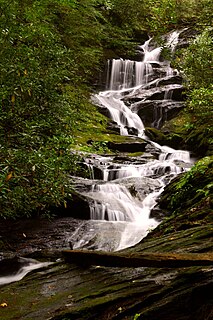
Courthouse Falls is a waterfall in Western North Carolina, located near Balsam Grove.
Toms Creek Falls is a waterfall in the Pisgah National Forest in McDowell County, North Carolina, near the town of Marion.

The Rice Fork is a 22.7-mile-long (36.5 km) tributary of the Eel River in Lake County, California. The Rice Fork begins on the upper northwest side of Goat Mountain, on the Colusa-Lake County line, at an elevation of over 6,000 feet (1,800 m). It quickly descends the steep western slope of the mountain, then bends northward, and flows northwesterly down a narrow winding steep walled canyon for about 18 miles (29 km), crossing two forest roads and adding many tributaries, ending its journey at the southern tip of Lake Pillsbury, at a varied elevation around 1,800 feet (550 m), depending on the lake level. Before the construction of Scott Dam in the 1920s, which formed Lake Pillsbury, the Rice Fork ran directly into the Eel River. It is one of Lake County's longest streams.

Doughton Park is the largest recreation area the National Park Service manages on the Blue Ridge Parkway. It is located between mile markers 238.5 - 244.7 and at 36° 30' 59.0394" N, -81° 8' 40.92" W. The park is named after North Carolina politician Robert L. Doughton.

Mingo Falls is a 120 ft (37 m) high waterfall located in the Qualla Boundary—a land trust of the Eastern Band of Cherokee Indians—near the town of Cherokee, Swain County, North Carolina in the Blue Ridge Mountains of the eastern United States. The waterfall is among the tallest in the southern Appalachians.

The Barberville Falls is a waterfall and nature preserve located in Poestenkill, New York. The fall flows into the Poesten Kill, which is a large creek that flows through Rensselaer County.

Farlow Gap is a popular trail for mountain biking and hiking, located in the western area of North Carolina. It is an expert-level trail, and considered "one of the toughest mountain bike trails in Pisgah National Forest." It is primarily a downhill trail, about 3.1 miles (5.0 km) in length. It can be combined with other trails to form a loop of about 14 miles (23 km), requiring anywhere from three to six hours to complete.