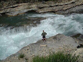
Whitewater forms in a rapid context, in particular, when a river's gradient changes enough to generate so much turbulence that air is trapped within the water. This forms an unstable current that froths, making the water appear opaque and white.

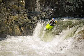
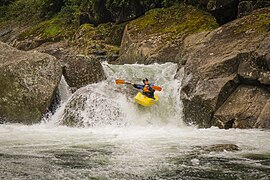
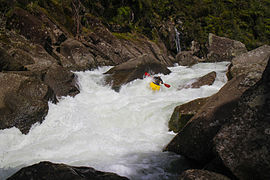
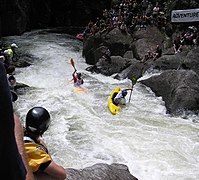
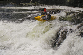
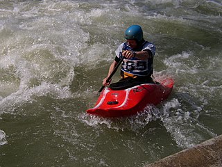
Whitewater kayaking is an adventure sport where a river is navigated in a decked kayak. Whitewater kayaking includes several styles. River running; where the paddler follows a river and paddles rapids as they travel. Creeking usually involving smaller, steeper, and more technical waterways. Creek boats tend to be short but high volume to allow for manoeuvrability while maintaining buoyancy. Slalom requires paddlers to navigate through "gates". Slalom is the only whitewater event to be in the Olympics. Play boating involves staying on one feature of the river and is more artistic than the others. Squirt boating uses low-volume boats to perform special moves in whitewater features.

The Kaituna River is in the Bay of Plenty region of the North Island of New Zealand. It is the outflow from Lakes Rotorua and Rotoiti, and flows northwards for 45 kilometres (28 mi), emptying into the Bay of Plenty near Te Puke. It was the subject of a claim concerning the effluent flowing down the river from Lake Rotorua, which resulted in movement to a land treatment system.

Manawa Energy limited is a New Zealand electricity generation company that offers bespoke electricity products to commercial and industrial customers across New Zealand. Manawa energy currently operate 26 power schemes from the Bay of Plenty in the north, to Otago in the south.

The East Coast Main Trunk (ECMT) is a railway line in the North Island of New Zealand, originally running between Hamilton and Taneatua via Tauranga, connecting the Waikato with the Bay of Plenty. The ECMT now runs between Hamilton and Kawerau, with a branch line to Taneatua from the junction at Hawkens. The line is built to narrow gauge of 1,067 mm, the uniform gauge in New Zealand. It was known as the East Coast Main Trunk Railway until 2011, when the word "Railway" was dropped.

The Hurunui River is the fourth largest of the four principal rivers in north Canterbury, New Zealand, with a catchment area of 2,670 square kilometres (1,030 sq mi). The river flows from the eastern side of the Southern Alps, to the Pacific Ocean.

Creeking is a branch of canoeing and kayaking that involves descending very steep low-volume whitewater. It is usually performed in specialized canoes and kayaks specifically designed to withstand the extreme whitewater environment in which the activity occurs. In addition, the canoes and kayaks give the paddler improved performance and maneuverability needed to avoid river obstacles.

The Mohaka river is on the North Island of New Zealand in the east central region of Hawke’s Bay. Mohaka is a Maori word, roughly translated it means “place for dancing”. The iwi associated with the Mohaka River are Ngāti Pāhauwera, Ngāti Hineuru, Ngāti Tūwharetoa and Mana Ahuriri. The headwaters are found in the Kaweka and Kaimanawa ranges. From the range it winds southeast before twisting northeast and finally southeast again to empty into the Pacific Ocean near the town of Mohaka. There are many gorges on the Mohaka; some as steep as 200m. Its main tributaries are the Waipunga, Taharua, Hautapu rivers. The full length is 172 kilometres (107 mi) and it drains a basin of 2,357 square kilometres (910 sq mi).

The Kaimai Tunnel is a railway tunnel through the Kaimai Range in the North Island of New Zealand. Since it was opened in 1978, it has held the title of longest tunnel, at 8.879 kilometres (5.517 mi), in New Zealand, assuming this distinction from the previous title holder, the Rimutaka Tunnel. It is part of the Kaimai Deviation, which was constructed to bypass the old route of the East Coast Main Trunk Railway through the Karangahake Gorge.
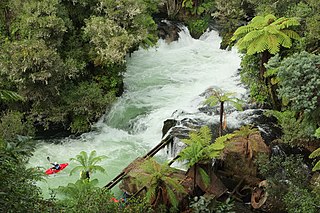
Okere Falls is a small town located 21 km from Rotorua on SH 33 between Rotorua and Tauranga on the North Island of New Zealand. The town is situated on the shore of the Okere Inlet of Lake Rotoiti, from which the Kaituna River flows north towards the Bay of Plenty.
Whitewater canoeing is the sport of paddling a canoe on a moving body of water, typically a whitewater river. Whitewater canoeing can range from simple, carefree gently moving water, to demanding, dangerous whitewater. River rapids are graded like ski runs according to the difficulty, danger or severity of the rapid. Whitewater grades range from I or 1 to VI or 6. Grade/Class I can be described as slightly moving water with ripples. Grade/Class VI can be described as severe or almost unrunnable whitewater, such as Niagara Falls.
The Kaimai hydro power scheme is a hydroelectric power scheme on the Wairoa River in the Bay of Plenty in New Zealand. The scheme is operated by TrustPower. It has four operational power stations, and formerly the McLaren Falls Station which was decommissioned in 1989 following the commissioning of the Ruahihi Station.

The Odyssey is a roller coaster at Fantasy Island in Ingoldmells, England. Built by Vekoma of the Netherlands in 2002, it was named to commemorate the Golden Jubilee of Queen Elizabeth II. It is Vekoma's tallest example of their Suspended Looping Coaster (SLC) design in the world. Standing at 167 feet, it is the third tallest roller coaster in the UK, after the Big One and Stealth. And the joint second tallest full circuit inverted rollercoaster in the world. It has a maximum speed of 63 mph and is capable of forces up to 4.8g.

The Omanawa River is a river of the Bay of Plenty Region of New Zealand's North Island.
The Opuiaki River is a river of the Bay of Plenty Region of New Zealand's North Island. It flows north from the Mamaku Plateau into Lake McLaren, to reach the Wairoa River 15 kilometres (9 mi) southwest of Tauranga.

The Mangapapa River is a river of the Bay of Plenty Region of New Zealand's North Island. It rises on the north slopes of the Mamaku Plateau at the southern end of the Kaimai Range and meets the Opuiaki River at the head of Lake McLaren, which discharges to the Wairoa River a short distance downstream from the lake at the confluence with the Mangakarengorengo River.
The Wainui River is a river of the Bay of Plenty Region of New Zealand's North Island. It flows north from the Kaimai Range to reach Tauranga Harbour 10 kilometres (6 mi) south of Katikati. The catchment has 191 km (119 mi) of stream margins. 41% of the catchment remains covered in native bush, but 48% is under pasture and suffers soil erosion.

State Highway 29 (SH 29) is a New Zealand state highway that travels over the Kaimai Ranges linking the Bay of Plenty and Waikato regions. For most of its length, SH 29 is a two-lane single carriageway with occasional passing lanes and slow vehicle bays. 5 km of it near its eastern terminus is part of the Takitimu Drive Toll Road.
The Omanawa Falls Power Station is a run of the river hydroelectric facility on the Omanawa River, in the Bay of Plenty in New Zealand. Built in 1915 to supply electricity to the town of Tauranga, it was the Southern Hemisphere's first underground power station.