Fort William is a town in Lochaber in the Scottish Highlands, located on the eastern shore of Loch Linnhe. As of the 2011 Census, Fort William had a population of 10,459, making it the second largest settlement in the Highland council area, and the second largest settlement in the whole of the Scottish Highlands; only the city of Inverness has a larger population.

The River Ness is a river in Highland, Scotland, UK. It flows from Loch Dochfour, at the northern end of Loch Ness, north-east to the mouth of the Beauly Firth at Inverness, a distance of about 6 miles, with a fall in height of about 16 metres. The river is the origin of the name of Inverness which is from Scottish Gaelic: Inbhir Nis, meaning "Mouth of the Ness".
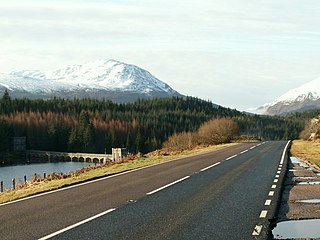
The A82 is a major road in Scotland that runs from Glasgow to Inverness via Fort William. It is one of the principal north-south routes in Scotland and is mostly a trunk road managed by Transport Scotland, who view it as an important link from the Central Belt to the Scottish Highlands and beyond. The road passes close to numerous landmarks, including; Loch Lomond, Rannoch Moor, Glen Coe, the Ballachulish Bridge, Ben Nevis, the Commando Memorial, Loch Ness, and Urquhart Castle.
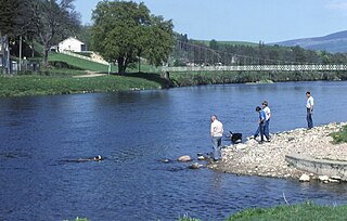
The River Spey is a river in the northeast of Scotland. It is the eighth longest river in the United Kingdom, as well as the second longest and fastest-flowing river in Scotland. It is important for salmon fishing and whisky production.

Spean Bridge railway station is a railway station serving the village of Spean Bridge in the Highland region of Scotland. This station is on the West Highland Line.
Laggan is the name of numerous places in Scotland, including:

The Great Glen Way is a long distance path in Scotland. It follows the Great Glen, running from Fort William in the southwest to Inverness in the northeast, covering 125 kilometres (78 mi). It was opened in 2002, and is designated as one of Scotland's Great Trails by NatureScot. The Great Glen Way is generally walked from southwest to northeast to follow the direction of the prevailing wind. It can be walked in 5–7 days, or cycled in 2–3 days. The trail is maintained and improved by the Great Glen Ways partnership, which consists of Highland Council, Scottish Canals and Forestry and Land Scotland. About 30,000 people use the path every year, of whom about 4,500 complete the entire route.

Glen Roy in the Lochaber area of the Highlands of Scotland is a glen noted for the geological phenomenon of three loch terraces known as the Parallel Roads of Glen Roy. The terraces formed along the shorelines of an ancient ice-dammed loch that existed during a brief period of climatic deterioration, during a much longer period of deglaciation, subsequent to the last main ice age. From a distance they resemble man-made roads running along the side of the glen, hence the name. Much of the glen is designated as a national nature reserve.
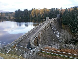
Laggan Dam is a dam located on the River Spean south west of Loch Laggan in the Scottish Highlands.

Loch Laggan is a freshwater loch situated approximately 6+1⁄2 mi (10.5 km) west of Dalwhinnie in the Scottish Highlands. The loch has an irregular shape, runs nearly northeast to southwest and is approximately 7 mi (11 km) in length. It has an average depth of 68 ft (21 m) and is 174 ft (53 m) at its deepest. The eastern end of the loch features the largest freshwater beach in Britain. Since 1934 Loch Laggan has been part of the Lochaber hydro-electric scheme. At the northeast end of the loch is the hamlet of Kinloch Laggan.
The A86 is a major road in Scotland. It runs from the Great Glen at Spean Bridge to Kingussie and the Cairngorms National Park via Loch Laggan. It is a primary route for its entire length.
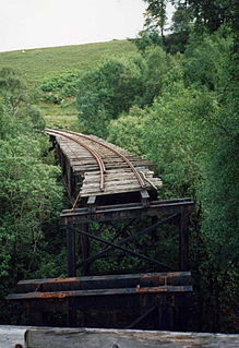
The Lochaber Narrow Gauge Railway was a 3 ft narrow-gauge industrial railway. It was a relatively long line, built for the construction and subsequent maintenance of a 15-mile-long (24-kilometre) tunnel from Loch Treig to a factory near Fort William in Scotland. The tunnel was excavated to carry water for the Lochaber hydroelectric scheme in connection with aluminium production by British Aluminium. The railway came to be known colloquially as the 'Old Puggy Line'.

Sròn a’ Choire Ghairbh is a Scottish mountain situated on the northern side of Loch Lochy, 13 kilometres north of Spean Bridge in the Highland Council area.

Meall na Teanga is a Scottish mountain located in the Highland council area, 11 km (7 mi) north of Spean Bridge.

Ben Tee is a Scottish mountain situated in the Lochaber area of the Highland council area, some 15 kilometres north of Spean Bridge. It is rated as one of the best of Scotland's smaller mountains with Hamish Brown saying:
Ben Tee is such a shapely cone that it is instantly recognisable from anywhere around the Great Glen or along the Garry. Its isolated situation makes it one of Scotland’s finest summit viewpoints.

Beinn a' Chaorainn is a Scottish mountain situated on the northern side of Glen Spean in the Lochaber region of the Highland Council area. The mountain which is located 30 km east-northeast of Fort William is one of several of the same name in the Scottish Highlands and should not be confused with another well known Beinn a' Chaorainn in the Cairngorms.
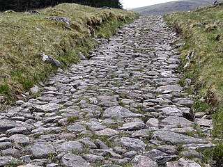
A network of military roads, sometimes called General Wade's Military Roads, was constructed in the Scottish Highlands during the middle part of the 18th century as part of an attempt by the British Government to bring order to a part of the country which had risen up in the Jacobite rebellion of 1715.

The East Highland Way is a long distance walking route in Scotland that connects Fort William (56.8178°N 5.1109°W) with the ski and mountain resort of Aviemore (57.1899°N 3.8292°W). The route was described by Kevin Langan in 2007. The name is derived from the fact that the route terminates in Aviemore at the eastern edge of Highland region. The EHW route takes in a varied and wild landscape through deep forest plantations, passing many highland lochs and negotiating unspoilt marshlands. The route also explores the ancient Caledonian forests of Inshriach. The walk is 82 miles (132 km) long.

The Lairig an Laoigh is a mountain pass through the Highlands of Scotland. In speech and sometimes in writing the name is reduced to "Lairig Laoigh". It is of glacial origin, dissecting the Cairngorm plateau, and it runs roughly north–south from Speyside to Deeside at one time being used as a drove road. Between the public road in the Abernethy Forest and the one at Linn of Dee the trekking distance is 31 kilometres (19 mi).

The River Lochy flows southwest along the Great Glen from Loch Lochy to Loch Linnhe at Fort William in the West Highlands of Scotland. Its two major tributaries are the short River Arkaig which drains Loch Arkaig into Loch Lochy and the River Spean which enters on its left bank at Gairlochy. The A830 road crosses the Lochy near its junction with the A82 road by means of the Victoria or Lochy Bridge just northeast of Fort William and the river is bridged again east of Gairlochy by the B8004 road. The only other crossing of the Lochy is a combined rail and foot bridge 500 metres (1,600 ft) downstream from Victoria Bridge. This span takes the West Highland Line between Fort William and Mallaig and carries the Great Glen Way national trail.