
The Santiam River is a tributary of the Willamette River, about 12 miles (19 km) long, in western Oregon in the United States. Through its two principal tributaries, the North Santiam and the South Santiam rivers, it drains a large area of the Cascade Range at the eastern side of the Willamette Valley east of Salem and Corvallis.

Mount Jefferson is a stratovolcano in the Cascade Volcanic Arc, part of the Cascade Range in the U.S. state of Oregon. The second highest mountain in Oregon, it is situated within Linn County, Jefferson County, and Marion County and forms part of the Mount Jefferson Wilderness. Due to the ruggedness of its surroundings, the mountain is one of the hardest volcanoes to reach in the Cascades. It is also a popular tourist destination despite its remoteness, with recreational activities including hiking, backpacking, mountaineering, and photography. Vegetation at Mount Jefferson is dominated by Douglas fir, silver fir, mountain hemlock, ponderosa pine, lodgepole pine, and several cedar species. Carnivores, insectivores, bats, rodents, deer, birds, and various other species inhabit the area.

White River is a river, approximately 195 miles (314 km) long, in the U.S. states of Colorado and Utah and is a tributary of the Green River.

The Clackamas River is an approximately 83-mile (134 km) tributary of the Willamette River in northwestern Oregon, in the United States. Draining an area of about 940 square miles (2,435 km2), the Clackamas flows through mostly forested and rugged mountainous terrain in its upper reaches, and passes agricultural and urban areas in its lower third. The river rises in eastern Marion County, about 55 miles (89 km) east-southeast of Salem. The headwaters are on the slopes of Olallie Butte in the Mount Hood National Forest, about 10 miles (16 km) north of Mount Jefferson, at an elevation of 4,909 feet (1,496 m) in the Cascade Range. The Clackamas flows briefly north and then flows northwest through the mountains, passing through North Fork Reservoir and Estacada. It then emerges from the mountains southeast of Portland. It joins the Willamette near Oregon City and forms the boundary between Oregon City and Gladstone.

The McKenzie River is a 90-mile (145 km) tributary of the Willamette River in western Oregon in the United States. It drains part of the Cascade Range east of Eugene and flows westward into the southernmost end of the Willamette Valley. It is named for Donald McKenzie, a Scottish Canadian fur trader who explored parts of the Pacific Northwest for the Pacific Fur Company in the early 19th century. As of the 21st century, six large dams have been built on the McKenzie and its tributaries.

The North Santiam River is a 92-mile (148 km) tributary of the Santiam River in western Oregon in the United States. It drains 766 square miles (1,980 km2) of the Cascade Range on the eastern side of the Willamette Valley east of Salem.

The South Santiam River is a tributary of the Santiam River, about 69 miles (111 km) long, in western Oregon in the United States. It drains an area of the Cascade Range into the Willamette Valley east of Corvallis.

The Sauk River is a tributary of the Skagit River, approximately 45 miles (72 km) long, in northwestern Washington in the United States. It drains an area of the high Cascade Range in the watershed of Puget Sound north of Seattle. The river is a popular destination for fly fishing. It is a National Wild and Scenic River.
The Willamette National Forest is a National Forest located in the central portion of the Cascade Range of the U.S. state of Oregon. It comprises 1,678,031 acres (6,790.75 km2). Over 380,000 acres are designated wilderness which include seven major mountain peaks. There are also several National Wild and Scenic Rivers within the forest. The forest is named for the Willamette River, which has its headwaters in the forest. The forest's headquarters are located in the city of Springfield. There are local ranger district offices in McKenzie Bridge, Detroit, Sweet Home, and Westfir.
The Collawash River is a 12-mile (19 km) tributary of the Clackamas River in the U.S. state of Oregon. Formed by the confluence of Elk Lake Creek and the East Fork Collawash River in the Cascade Range, it flows generally north-northwest from source to mouth through the Mount Hood National Forest. The largest tributary of the upper Clackamas, it provides about a third of bigger river's low-flow volume. About 35 percent of its watershed of 150 square miles (390 km2) is protected as wilderness.
Breitenbush is an unincorporated community in Marion County, Oregon, United States, located approximately 10 miles NE of Detroit, Oregon, and 10 miles NW of Mt. Jefferson. The community is situated on private land, encompassed entirely by the Willamette National Forest, and is notable for having several hot springs, both nearby and on the property. It is said to have been originally homesteaded in 1888, and its hot springs have seen varied degrees of development and use since that time. In its heyday as a resort, the community was served by a post office, which operated between 1928 and 1953.

The Naches River is a tributary of the Yakima River in central Washington in the United States. Beginning as the Little Naches River, it is about 75 miles (121 km) long. After the confluence of the Little Naches and Bumping River the name becomes simply the Naches River. The Naches and its tributaries drain a portion of the eastern side of the Cascade Range, east of Mount Rainier and northeast of Mount Adams. In terms of discharge, the Naches River is the largest tributary of the Yakima River.

The Sol Duc River is a river in the U.S. state of Washington. About 78 miles (126 km) long, it flows west through the northwest part of the Olympic Peninsula, from the Olympic Mountains of Olympic National Park and Olympic National Forest, then through the broad Sol Duc Valley. Near the Pacific Ocean the Sol Duc River joins the Bogachiel River, forming the Quillayute River, which flows about 4 miles (6.4 km) to the Pacific Ocean at La Push. Although the Quillayute River is short, its large tributary rivers—the Sol Duc, Bogachiel, Calawah, and Dickey Rivers—drain the largest watershed of the northern Olympic Peninsula, 629 square miles (1,630 km2). The Sol Duc's watershed is the largest of the Quillayute's tributaries, at 219 square miles (570 km2).

Quartzville Creek is a 28-mile (45 km) tributary of the Middle Santiam River in Linn County in the U.S. state of Oregon. It is paralleled by the Quartzville Back Country Byway and used for recreation, including camping, fishing, hunting, kayaking, and gold panning. The lower 12 miles (19 km) of the creek, from the Willamette National Forest boundary to Green Peter Reservoir, was designated Wild and Scenic in 1988.

Little Butte Creek is a 17-mile-long (27 km) tributary of the Rogue River in the U.S. state of Oregon. Its drainage basin consists of approximately 354 square miles (917 km2) of Jackson County and another 19 square miles (49 km2) of Klamath County. Its two forks, the North Fork and the South Fork, both begin high in the Cascade Range near Mount McLoughlin and Brown Mountain. They both flow generally west until they meet near Lake Creek. The main stem continues west, flowing through the communities of Brownsboro, Eagle Point, and White City, before finally emptying into the Rogue River about 3 miles (5 km) southwest of Eagle Point.

Big Butte Creek is a 12-mile-long (19 km) tributary of the Rogue River in the U.S. state of Oregon. It drains approximately 245 square miles (635 km2) of Jackson County. Its two forks, the North Fork and the South Fork, both begin high in the Cascade Range near Mount McLoughlin. Flowing predominantly west, they meet near the city of Butte Falls. The main stem flows generally northwest until it empties into the Rogue Falls was incorporated in 1911, and remains the only incorporated town within the watershed's boundaries.

The B&B Complex fires were a linked pair of wildfires that together burned 90,769 acres (367.33 km2) of Oregon forest during the summer of 2003. The fire complex began as two separate fires, the Bear Butte Fire and the Booth Fire. The two fires were reported on the same day and eventually burned together, forming a single fire area that stretched along the crest of the Cascade Mountains between Mount Jefferson and Mount Washington. On the western side of the Cascades, the fire consumed mostly Douglas-fir and western hemlock. On the eastern side of the mountains, the fire burned mostly Ponderosa pine, lodgepole pine, and jack pine. Most of the burned area was on public land administered by the United States Forest Service including 40,419 acres (163.57 km2) within the Mount Jefferson Wilderness. The fire also burned forest land on the Warm Springs Indian Reservation and small areas of state and private land. Firefighters battled the blaze for 34 days. At the peak of the firefighting effort, there were over 2,300 personnel working on the fire. Although the cost of fire suppression was over $38 million, there were no deaths and no homes burned as the fire was largely in wilderness areas.

The North Fork Breitenbush River is a tributary of the Breitenbush River in the U.S. state of Oregon. It begins at Papoose Lakes near Breitenbush Lake in the Cascade Range north of Mount Jefferson and flows generally northwest and west through the Mount Hood National Forest, Olallie Scenic Area, Mount Jefferson Wilderness, and Willamette National Forest. It merges with the South Fork Breitenbush River to form the Breitenbush River main stem slightly upstream of Breitenbush Hot Springs.
The South Fork Breitenbush River is a 10-mile (16 km) tributary of the Breitenbush River in the U.S. state of Oregon. The river flows generally northwest from Russell Lake in the Mount Jefferson Wilderness of the Cascade Range to near Breitenbush Hot Springs, where it merges with the North Fork Breitenbush River to form the main stem.

Crabtree Creek is a tributary of the South Santiam River in Linn County in the U.S. state of Oregon. It begins in the western foothills of the Cascade Range at Crabtree Mountain near Crabtree Lake. From there it flows generally west to meet the larger stream about 3 miles (5 km) upstream of where the South Santiam merges with the North Santiam River to form the Santiam River.


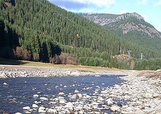
 View of tributary from road to Breitenbush Lake of North Fork Of North Fork of Breitenbush River
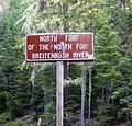 Weathered road sign naming North Fork of North Fork Breitenbush River
 Jefferson Park at the foot of Mount Jefferson, headwaters of the South Fork of the Breitenbush River
 View of river from Breitenbush Hot Springs


