Summersville, West Virginia

Last updated

Summersville, West Virginia
Summersville West Virginia Broad Street.jpg
Main Street (West Virginia Route 41) in downtown Summersville in 2007
Flag of Summersville, West Virginia.svg
Logo of Summersville, West Virginia.svg
Nickname: 
The World's Largest Speed Trap[ citation needed ]
Nicholas County West Virginia Incorporated and Unincorporated areas Summersville Highlighted.svg
Location of Summersville in Nicholas County, West Virginia.
Coordinates: 38°17′0″N80°50′39″W / 38.28333°N 80.84417°W / 38.28333; -80.84417
Country United States
State West Virginia
County Nicholas
Founded1824
Government
  MayorRobert Shafer [1]
Area
[2]
  Total4.53 sq mi (11.73 km2)
  Land4.49 sq mi (11.62 km2)
  Water0.04 sq mi (0.11 km2)
Elevation
1,880 ft (573 m)
Population
 (2020) [3]
  Total3,459
  Estimate 
(2021) [3]
3,408
  Density729.66/sq mi (281.75/km2)
Time zone UTC-5 (Eastern (EST))
  Summer (DST) UTC-4 (EDT)
ZIP code
26651
Area code(s) 304, 681
FIPS code 54-77980 [4]
GNIS feature ID1547739 [5]
Website Official website

Summersville is a city in Nicholas County, West Virginia, United States. The population was 3,459 at the 2020 census. [3] It is the county seat of Nicholas County. [6]

Contents

History

Summersville was laid out in 1824. [7] The city was named for Lewis Summers, a local judge who had introduced the bill to create Nicholas County. [8]

Summersville was home to both Union and Confederate encampments during the Civil War. The town was mostly burned down by the Confederate spy Nancy Hart Douglas during the war. The town was rebuilt by 1884. [9]

In 1914, Nicholas County High School was established, then located downtown in the "Old Main". More buildings were built on the campus to house the growing student body until a new building north of town was finished in 1978.

Construction on Summersville Dam began in 1960 and was finished and dedicated by President Lyndon Baines Johnson in 1966. [9]

Since the upgrade of U.S. Route 19 through Summersville from a two lane highway to a four lane highway, the city has become the economic center of Nicholas County. The road is commonly used by northern travelers as a shortcut to the south.

Summersville is home to the annual Potato Festival.

On June 23, 2016 flooding impacted Summersville. This resulted in Summersville Middle School being demolished and relocated to a modular setting after flood waters damaged the school. Ground was broken on a new campus for Summersville Middle School, Nicholas County High School, and the Nicholas County Career and Technical Center on June 2, 2020. [10]

Geography

Summersville is located at 38°17′0″N80°50′39″W / 38.28333°N 80.84417°W / 38.28333; -80.84417 (38.283342, -80.844207). [11] It is located just north of the Gauley River which is famous for its challenging whitewater. The river is impounded by a large dam which creates Summersville Lake, creating flatwater recreation as well.

According to the United States Census Bureau, the town has a total area of 4.26 square miles (11.03 km2), of which 4.22 square miles (10.93 km2) is land and 0.04 square miles (0.10 km2) is water. [12]

Climate

The climate in this area has mild differences between highs and lows, and there is adequate rainfall year-round. According to the Köppen Climate Classification system, Summersville has a marine west coast climate, abbreviated "Cfb" on climate maps. [13]

Demographics

Historical population
CensusPop.Note
1880 165
1900 223
1910 204−8.5%
1920 27936.8%
1930 53692.1%
1940 64320.0%
1950 1,628153.2%
1960 2,00823.3%
1970 2,42921.0%
1980 2,97222.4%
1990 2,906−2.2%
2000 3,29413.4%
2010 3,5728.4%
2020 3,459−3.2%
2021 (est.)3,408 [3] −1.5%
U.S. Decennial Census [14]
Nicholas County Courthouse in 2007 Nicholas County Courthouse Summersville.jpg
Nicholas County Courthouse in 2007

The median income for a household in the town was $29,783, and the median income for a family was $43,314. Males had a median income of $33,633 versus $22,348 for females. The per capita income for the town was $23,217. About 6.9% of families and 12.7% of the population were below the poverty line, including 8.1% of those under age 18 and 11.2% of those age 65 or over.

As of 2018 Summersville has been home to a major economical increase due to a 303 mi 42in. natural gas pipeline running through eastern Nicholas county, bringing in close to 1,000 more people to the county generating more revenue for businesses, Lodging and much more.

2010 census

As of the census [15] of 2010, there were 3,572 people, 1,640 households, and 974 families living in the town. The population density was 846.4 inhabitants per square mile (326.8/km2). There were 1,761 housing units at an average density of 417.3 per square mile (161.1/km2). The racial makeup of the town was 97.4% White, 0.4% African American, 0.3% Native American, 0.9% Asian, 0.3% from other races, and 0.7% from two or more races. Hispanic or Latino of any race were 1.4% of the population.

There were 1,640 households, of which 26.3% had children under the age of 18 living with them, 42.1% were married couples living together, 13.6% had a female householder with no husband present, 3.7% had a male householder with no wife present, and 40.6% were non-families. 36.8% of all households were made up of individuals, and 14.9% had someone living alone who was 65 years of age or older. The average household size was 2.14 and the average family size was 2.77.

The median age in the town was 43 years. 20.4% of residents were under the age of 18; 7.9% were between the ages of 18 and 24; 24.2% were from 25 to 44; 30.4% were from 45 to 64; and 17.1% were 65 years of age or older. The gender makeup of the town was 46.8% male and 53.2% female.

Education

Summersville is served by the Nicholas County Board of Education, which operates three schools, Summersville Elementary School, Summersville Middle School (Summersville Junior High School until 2006), and Nicholas County High School, in Summersville.

Summersville is also home to New Life Christian Academy, a private school.

New River Community and Technical College maintains a campus in Summersville.

In media

Summersville and surrounding locations are featured in the 2018 video game Fallout 76.

See also

Related Research Articles

<span class="mw-page-title-main">Webster County, West Virginia</span> County in West Virginia, United States

Webster County is a county in the U.S. state of West Virginia. As of the 2020 census, the population was 8,378. Its county seat is Webster Springs. The county was founded in 1860 and named for Daniel Webster.

<span class="mw-page-title-main">Nicholas County, West Virginia</span> County in West Virginia, United States

Nicholas County is a county located in the central region of U.S. state of West Virginia. As of the 2020 census, the population was 24,604. Its county seat is Summersville. The county was created in 1818 by the Virginia General Assembly and named for Virginia Governor Wilson Cary Nicholas.

<span class="mw-page-title-main">Perham, Maine</span> Town in the state of Maine, United States

Perham is a town in Aroostook County, Maine, United States. The population was 371 at the 2020 census. The town was named after Maine's 33rd governor, Sidney Perham.

<span class="mw-page-title-main">Jackson Township, Mercer County, Pennsylvania</span> Township in Pennsylvania, United States

Jackson Township is a township in Mercer County, Pennsylvania, United States. The population was 1,181 at the 2020 census, a decrease from the figure of 1,273 in 2010.

<span class="mw-page-title-main">Glen Lyn, Virginia</span> Town in Virginia, United States

Glen Lyn is a town in Giles County, Virginia, United States, at the confluence of the East and New rivers. The population was 115 at the 2010 census, down from 151 at the 2000 census. It is part of the Blacksburg–Christiansburg Metropolitan Statistical Area.

<span class="mw-page-title-main">Halifax, Virginia</span> Town in Virginia, United States

Halifax is a town in Halifax County, Virginia, United States, along the Banister River. The population was 1,309 at the 2010 census. It is the county seat of Halifax County.

<span class="mw-page-title-main">Pennington Gap, Virginia</span> Town in Virginia, United States

Pennington Gap is a town in Lee County, Virginia, United States. The population was 1,624 at the 2020 census.

<span class="mw-page-title-main">Sutton, West Virginia</span> Town in West Virginia

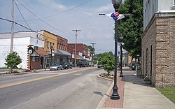
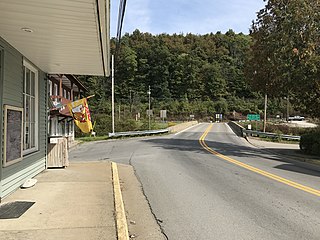
Sutton is a town in Braxton County, West Virginia, United States. The population was 876 at the 2020 census. It is the county seat of Braxton County. Sutton is situated at a center of transportation in West Virginia. Interstate 79, a major north–south route, connects with Appalachian Corridor L, another significant north–south route, passes several miles south of town.

<span class="mw-page-title-main">Grantsville, West Virginia</span> Town in West Virginia, United States

Grantsville is a town in Calhoun County, West Virginia, United States. The population was 482 at the 2020 census. It is the county seat of Calhoun County. The town was established along the Little Kanawha River in 1865 and named for Ulysses S. Grant. Grantsville is home to Wayne Underwood Park, which includes a .25-mile-long (0.40 km) walking trail, and to the annual West Virginia Wood Festival.

<span class="mw-page-title-main">Gauley Bridge, West Virginia</span> Town in West Virginia, United States

Gauley Bridge is a town in Fayette County, West Virginia, United States. The population was 614 at the 2010 census. The Kanawha River is formed at Gauley Bridge by the confluence of the New and Gauley Rivers. Two miles to the southwest of Gauley Bridge, in Glen Ferris, is Kanawha Falls, a popular stopping point on Midland Trail Scenic Highway.

<span class="mw-page-title-main">Jane Lew, West Virginia</span> Town in West Virginia, United States

Jane Lew is a town in Lewis County, West Virginia, United States. The population was 409 at the time of the 2020 census.

<span class="mw-page-title-main">Man, West Virginia</span> Town in West Virginia, United States

Man is a town in Logan County, West Virginia, United States. The population was 772 at the 2020 census. The town is located along the Guyandotte River at the mouth of Buffalo Creek, which was the site of the 1972 Buffalo Creek Flood following a dam collapse. The name of the town reportedly derives from the last syllable of the surname of Ulysses Hinchman, who was a member of the House of Delegates from Logan County between 1866 and 1869.

<span class="mw-page-title-main">Richwood, West Virginia</span> City in West Virginia, United States

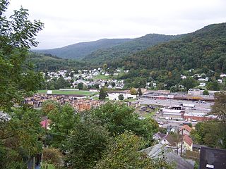
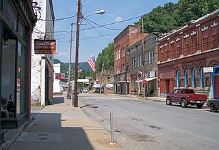
Richwood is a city in Nicholas County, West Virginia, United States. In 2020, the census showed Richwood with a population of 1,661. During the 19th and early 20th century Richwood was a booming coal and lumber town. Richwood has a very rich history, including the formation of the Cherry River Navy civic organization to draw attention to issues important to the community. Richwood has also become known statewide as the "Ramp Capital of the World". Each year, in April, the city hosts a large festival that draws visitors from around the country.

<span class="mw-page-title-main">Albright, West Virginia</span> Town in West Virginia, United States

Albright is a town in central Preston County, West Virginia, United States, along the Cheat River. The population was 260 at the 2020 census. A former coal town, it is part of the Morgantown metropolitan area.

<span class="mw-page-title-main">Bruceton Mills, West Virginia</span> Town in West Virginia, United States

Bruceton Mills is a town in northern Preston County, West Virginia, United States, along Big Sandy Creek. The population was 64 at the 2020 census, making it the second-least populous town in West Virginia, after Thurmond. It is part of the Morgantown metropolitan area.

<span class="mw-page-title-main">Eleanor, West Virginia</span> Town in West Virginia, United States

Eleanor is a town in Putnam County, West Virginia, United States, along the Kanawha River. Its population was 1,548 at the 2020 census. It is part of the Huntington–Ashland metropolitan area. The town, named for Eleanor Roosevelt, was established as a New Deal project in the 1930s like other Franklin D. Roosevelt towns around the nation.

<span class="mw-page-title-main">Middlebourne, West Virginia</span> Town in West Virginia, United States

Middlebourne is a town in Tyler County, West Virginia, United States. The population was 715 at the 2020 census. It serves as the county seat of Tyler County.

<span class="mw-page-title-main">Camden-on-Gauley, West Virginia</span> Town in West Virginia, United States

Camden-on-Gauley is a town in Webster County, West Virginia, United States, along the Gauley River. The population was 126 at the 2020 census.

<span class="mw-page-title-main">Elizabeth, West Virginia</span> Town in West Virginia, United States

Elizabeth is a town in and the county seat of Wirt County, West Virginia, United States, situated along the Little Kanawha River. The population was 724 as of the 2020 census.

<span class="mw-page-title-main">Summersville, Missouri</span> City in Missouri, United States

Summersville is a city in Shannon and Texas counties in the U.S. state of Missouri. The population was 453 at the 2020 census.

References

  1. "Mayor | Summersville, West Virginia".
  2. "2019 U.S. Gazetteer Files". United States Census Bureau. Retrieved August 7, 2020.
  3. 1 2 3 4 "City and Town Population Totals: 2020-2021". Census.gov. US Census Bureau. Retrieved July 3, 2022.
  4. "U.S. Census website". United States Census Bureau . Retrieved January 31, 2008.
  5. "US Board on Geographic Names". United States Geological Survey. October 25, 2007. Retrieved January 31, 2008.
  6. "Find a County". National Association of Counties. Retrieved June 7, 2011.
  7. Kenny, Hamill (1945). West Virginia Place Names: Their Origin and Meaning, Including the Nomenclature of the Streams and Mountains. Piedmont, WV: The Place Name Press. p. 612.
  8. Capace, Nancy (1999). Encyclopedia of West Virginia. North American Book Dist LLC. p. 192. ISBN   978-0-403-09843-9.
  9. 1 2 "Summersville_History". Archived from the original on April 1, 2017. Retrieved June 13, 2020.
  10. [ dead link ]
  11. "US Gazetteer files: 2010, 2000, and 1990". United States Census Bureau. February 12, 2011. Retrieved April 23, 2011.
  12. "US Gazetteer files 2010". United States Census Bureau. Archived from the original on January 25, 2012. Retrieved January 24, 2013.
  13. Climate Summary for Summersville, West Virginia
  14. "Census of Population and Housing". Census.gov. Retrieved June 4, 2015.
  15. "U.S. Census website". United States Census Bureau . Retrieved January 24, 2013.