Franklin, West Virginia

Last updated

Franklin, West Virginia
Pendleton County Courthouse at Franklin West Virginia.jpg
Pendleton County Courthouse in Franklin
Seal of Franklin, West Virginia.png
Nickname: 
F-Town
Pendleton County West Virginia Incorporated and Unincorporated areas Franklin Highlighted.svg
Location of Franklin in Pendleton County, West Virginia.
Coordinates: 38°38′51″N79°19′54″W / 38.64750°N 79.33167°W / 38.64750; -79.33167
Country United States
State West Virginia
County Pendleton
Area
[1]
  Total0.56 sq mi (1.46 km2)
  Land0.56 sq mi (1.46 km2)
  Water0.00 sq mi (0.00 km2)
Elevation
1,732 ft (528 m)
Population
 (2020) [2]
  Total486
  Estimate 
(2021) [2]
482
  Density1,142.35/sq mi (440.93/km2)
Time zone UTC-5 (Eastern (EST))
  Summer (DST) UTC-4 (EDT)
ZIP code
26807
Area code 304
FIPS code 54-29044 [3]
GNIS feature ID1551175 [4]
Website https://www.townfranklinwv.com/

Franklin is a town in and the county seat of Pendleton County, West Virginia, United States. [5] The population was 486 at the 2020 census. [2] Franklin was established in 1794 and named for Francis Evick, an early settler.

Contents

History

The Town of Franklin is situated in the Allegheny Mountains on the eastern edge of the Monongahela National Forest and along the South Branch of the Potomac River. This region was populated by Native American cultures for centuries prior to the arrival of English immigrants in the mid-18th century. During the French and Indian War, conflict between the early settlers and Native American populations included two battles at frontier fortifications at Upper Tract and Fort Seybert in 1758, both ten miles distant from the future location of Franklin. The land on which Franklin was laid out was first patented by brothers Francis and George Evick in 1769. [6]

Main Street in downtown Franklin 2016-06-06 09 38 36 View south along U.S. Route 220 (Main Street) just south of Pine Street in Franklin, Pendleton County, West Virginia.jpg
Main Street in downtown Franklin

Pendleton County was divided from parts of Augusta, Hardy, and Rockingham Counties (Virginia) by an act of the Virginia General Assembly in 1787. [7] The earliest court sessions in the new county were held at the home of Captain Zeruiah Stratton near the present-day village of Ruddle until Francis Evick offered a part of his land to become a county seat around 1789. [8] Additional lots were divided off of Evick's land to form the new town. On December 19, 1794, the Virginia General Assembly chartered the town of Franklin and recognized it as the seat of Pendleton County. [9] Franklin grew steadily over the first half of the 19th century, becoming a local center of commerce and industry. In 1834, there were two stores, two tanneries, three saddlers, two carpenters, two shoemakers, two blacksmiths, one gunsmith, one tailor, one hat-maker, and one cabinet-maker listed among the town's residents. [10]

At the outbreak of the American Civil War in 1861, Pendleton County voted to uphold Virginia's Ordinance of Secession, despite strong Union sympathies from many of its residents. [11] Localized fighting occurred between northern and southern regiments throughout the war, but the only major battle to impact the Franklin area occurred in May 1862. Following the First Battle of Kernstown, Confederate Major General Thomas J. "Stonewall" Jackson initiated his Valley Campaign to draw attention of the Union Army away from its Peninsula Campaign nearing the Confederate capitol at Richmond. On May 8, 1862, Jackson clashed with Union regiments from West Virginia and Ohio under the command of Brigadier General Robert H. Milroy at the Battle of McDowell (some 30 miles from Franklin). After a day of fighting, the Union forces withdrew from the battle and began retreating towards Franklin, pursued by Jackson for nearly a week. The armies clashed briefly at McCoy's Mill (three miles south of Franklin, now a National Historic Site), but Jackson withdrew and returned to the Shenandoah Valley to continue his campaign. [12]

Franklin did not grow significantly in the years following the American Civil War until the early twentieth century. In 1917, the town's boundaries were expanded, the streets were macadamized, and public water and electricity were brought into the town. [13] However, tragedy struck on April 17, 1924, when a massive fire destroyed the entire business district and caused $500,000.00 (~$6.5 million adjusted for present inflation) in damages. [14] Most of the town's center, its commercial district, and the Pendleton County Courthouse were constructed following the 1924 fire. Another disaster struck the town in 1985. The South Branch of the Potomac River in Franklin crested at 22.6 feet during the 1985 Election day floods. Flood stage at the time in the shallow riverbed was only 7 feet. [15]

Geography

Franklin is located at 38°38′51″N79°19′54″W / 38.64750°N 79.33167°W / 38.64750; -79.33167 (38.647400, -79.331557). [16]

According to the United States Census Bureau, the town has a total area of 0.56 square miles (1.45 km2), all land. [17]

Climate

The climate in this area has mild differences between highs and lows, and there is adequate rainfall year-round. According to the Köppen Climate Classification system, Franklin has a marine west coast climate, abbreviated "Cfb" on climate maps. [18]

Attractions

Aside from its historical sites, Franklin and Pendleton County are home to several recreational facilities. Franklin Gorge is a popular rock climbing destination. Franklin is within short distance of several of West Virginia's most celebrated state and national parks, including Seneca Rocks, Spruce Knob, and Smoke Hole Canyon.

Demographics

Historical population
CensusPop.Note
1880 273
1900 205
1910 200−2.4%
1920 32060.0%
1930 43134.7%
1940 61342.2%
1950 77726.8%
1960 758−2.4%
1970 695−8.3%
1980 78012.2%
1990 91417.2%
2000 797−12.8%
2010 721−9.5%
2020 486−32.6%
2021 (est.)482 [2] −0.8%
U.S. Decennial Census [19]

2010 census

As of the census [20] of 2010, there were 721 people, 313 households, and 173 families living in the town. The population density was 1,287.5 inhabitants per square mile (497.1/km2). There were 398 housing units at an average density of 710.7 per square mile (274.4/km2). The racial makeup of the town was 96.5% White, 1.0% African American, 0.6% Native American, 0.4% Asian, 0.4% from other races, and 1.1% from two or more races. Hispanic or Latino of any race were 0.7% of the population.

There were 313 households, of which 18.5% had children under the age of 18 living with them, 44.4% were married couples living together, 7.3% had a female householder with no husband present, 3.5% had a male householder with no wife present, and 44.7% were non-families. 40.9% of all households were made up of individuals, and 22.7% had someone living alone who was 65 years of age or older. The average household size was 2.00 and the average family size was 2.68.

The median age in the town was 55.5 years. 14.4% of residents were under the age of 18; 5.1% were between the ages of 18 and 24; 16% were from 25 to 44; 28.4% were from 45 to 64; and 36.2% were 65 years of age or older. The gender makeup of the town was 44.2% male and 55.8% female.

2000 census

As of the census [3] of 2000, there were 797 people, 362 households, and 222 families living in the town. The population density was 1,582.0 inhabitants per square mile (615.4/km2). There were 424 housing units at an average density of 841.6 per square mile (327.4/km2). The racial makeup of the town was 97.11% White, 2.01% African American, 0.25% Native American, .13% from other races, and 0.50% from two or more races. Hispanic or Latino of any race were 0.38% of the population.

There were 362 households, out of which 24.3% had children under the age of 18 living with them, 50.6% were married couples living together, 8.3% had a female householder with no husband present, and 38.4% were non-families. 35.1% of all households were made up of individuals, and 18.0% had someone living alone who was 65 years of age or older. The average household size was 2.17 and the average family size was 2.80.

In the town, the population was spread out, with 20.7% under the age of 18, 5.9% from 18 to 24, 23.8% from 25 to 44, 25.6% from 45 to 64, and 24.0% who were 65 years of age or older. The median age was 44 years. For every 100 females, there were 82.0 males. For every 100 females age 18 and over, there were 79.5 males.

The median income for a household in the town was $32,125, and the median income for a family was $40,500. Males had a median income of $23,839 versus $18,056 for females. The per capita income for the town was $15,609. About 6.0% of families and 11.1% of the population were below the poverty line, including 19.3% of those under age 18 and 6.0% of those age 65 or over.

Arts and culture

Festivals

The most popular festivals in Franklin are the Treasure Mountain Festival, which takes place annually the third weekend in September, and the annual Trout Fest in May. Both attract visitors from surrounding counties and states.

Historic sites

Bank of Franklin Bank of Franklin Franklin West Virginia.jpg
Bank of Franklin

Much of the town was listed on the National Register of Historic Places as the Franklin Historic District in 1986.

Dr. Preston Boggs House Preston Boggs House Franklin West Virginia.jpg
Dr. Preston Boggs House
Franklin Presbyterian Church Franklin Presbyterian Church West Virginia.jpg
Franklin Presbyterian Church
McCoy House McCoy House in Franklin West Virginia.jpg
McCoy House

Transportation

US 33 eastbound and US 220 southbound in Franklin 2019-05-14 10 48 23 View east along U.S. Route 33 and south along U.S. Route 220 (Main Street) at Crigler Lane in Franklin, Pendleton County, West Virginia.jpg
US 33 eastbound and US 220 southbound in Franklin

Transport to and from Franklin is primarily via two-lane rural mountain roads. U.S. Route 33 is the main east–west road through Franklin, while U.S. Route 220 is the primary north–south highway traversing the town. Both roads run concurrently for a short segment on the north side of the town.

Related Research Articles

<span class="mw-page-title-main">Pendleton County, West Virginia</span> County in West Virginia, United States

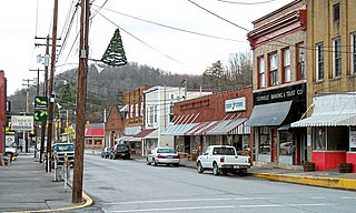
Pendleton County is a county located in the U.S. state of West Virginia. As of the 2020 census, the population was 6,143, making it the second-least populous county in West Virginia. Its county seat is Franklin. The county was created by the Virginia General Assembly in 1788 from parts of Augusta, Hardy, and Rockingham counties and was named for Edmund Pendleton (1721–1803), a distinguished Virginia statesman and jurist. Pendleton County was strongly pro-Confederate during the American Civil War; however, there were pockets of Unionists who supported the state government in Wheeling.

<span class="mw-page-title-main">Isle of Wight County, Virginia</span> County in Virginia, United States

Isle of Wight County is a county located in the Hampton Roads region of the U.S. state of Virginia. It was named after the Isle of Wight, England, south of the Solent, from where many of its early colonists had come. As of the 2020 census, the population was 38,606. Its county seat is Isle of Wight, an unincorporated community.

<span class="mw-page-title-main">Highland County, Virginia</span> County in Virginia, United States

Highland County is a county located in the Commonwealth of Virginia. As of the 2020 census, the population was 2,232, making it the state's least populous county. Its county seat is Monterey. Known as "Virginia's Switzerland" or "Virginia's Little Switzerland", Highland County is the least populous jurisdiction in Virginia, including counties and independent cities. Highland lays claim to being one of the least populous counties and one of the highest average elevations east of the Mississippi River.

<span class="mw-page-title-main">Augusta County, Virginia</span> County in Virginia, United States

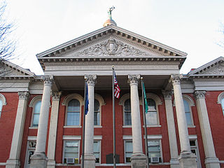
Augusta County is a county in the Shenandoah Valley on the western edge of the Commonwealth of Virginia in the United States. The second-largest county of Virginia by total area, it completely surrounds the independent cities of Staunton and Waynesboro. Its county seat is Staunton, but most of the administrative services have offices in neighboring Verona.

<span class="mw-page-title-main">Pendleton County, Kentucky</span> County in Kentucky, United States

Pendleton County is a county located in the U.S. state of Kentucky. As of the 2020 census, the population was 14,644. Its county seat is Falmouth. The county was founded December 13, 1798. Pendleton County is included in the Cincinnati-Middletown, OH-KY-IN Metropolitan Statistical Area.

<span class="mw-page-title-main">Edenton, North Carolina</span> Town in North Carolina, United States

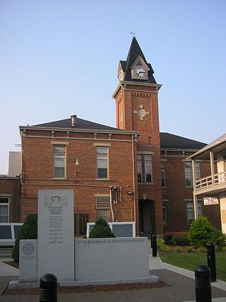
Edenton is a town in, and the county seat of, Chowan County, North Carolina, United States, on Albemarle Sound. The population was 4,397 at the 2020 census. Edenton is located in North Carolina's Inner Banks region. In recent years Edenton has become a popular retirement location and a destination for heritage tourism.

<span class="mw-page-title-main">York, South Carolina</span> City in South Carolina, United States

York is a city in and county seat of York County, South Carolina, United States. The population was approximately 6,985 at the 2000 census and up to 7,736 at the 2010 census. York is located approximately 27 miles (43 km) southwest of Charlotte, North Carolina and 13 miles (21 km) west of Rock Hill, South Carolina.

<span class="mw-page-title-main">Accomac, Virginia</span> Town in Virginia, United States

Accomac is a town in and the county seat of Accomack County, Virginia, United States. The population was 526 at the 2020 census.

<span class="mw-page-title-main">Fincastle, Virginia</span> Town in Virginia, United States

Fincastle is a town in Botetourt County, Virginia, United States. The population was 755 at the 2020 census. It is the county seat of Botetourt County.

<span class="mw-page-title-main">Lawrenceville, Virginia</span> Town in Virginia, United States

Lawrenceville is a town in Brunswick County, Virginia, United States. Per the 2020 census, the population was 1,014. Located by the Meherrin River, it is the county seat of Brunswick County. In colonial times, Lieutenant Governor Alexander Spotswood had a stockade built nearby, called Fort Christanna, where converted Native American allies were housed and educated.

<span class="mw-page-title-main">Berryville, Virginia</span> Town in Virginia

Berryville is an incorporated town in and the county seat of Clarke County, Virginia, United States. The population was 4,574 at the 2020 census, up from 4,185 at the 2010 census.

<span class="mw-page-title-main">Rocky Mount, Virginia</span> Town in Virginia, United States

Rocky Mount is a town in and the county seat of Franklin County, Virginia, United States. The town is part of the Roanoke Metropolitan Statistical Area, and had a population of 4,903 as of the 2020 census. It is located in the Roanoke Region of Virginia.

<span class="mw-page-title-main">Wytheville, Virginia</span> Town in Virginia, United States

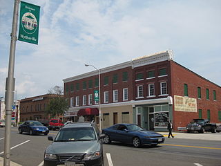
Wytheville is a town in, and the county seat of, Wythe County, Virginia, United States. It is named after George Wythe, a signer of the United States Declaration of Independence and mentor to Thomas Jefferson. Wytheville's population was 8,264 at the 2020 census. Interstate Highways 77 and 81 were constructed to intersect at the town, a long a crossroads for travelers.

<span class="mw-page-title-main">Glenville, West Virginia</span> Town in West Virginia, United States

Glenville is a town in and the county seat of Gilmer County, West Virginia, United States, along the Little Kanawha River. The population was 1,128 at the 2020 census. It is the home of Glenville State University.

<span class="mw-page-title-main">Petersburg, West Virginia</span> City in West Virginia, United States

Petersburg is a city in Grant County, West Virginia, United States. The population was 2,251 at the 2020 census. It is the county seat of Grant County.

<span class="mw-page-title-main">Welch, West Virginia</span> City in West Virginia, United States

Welch is a city in and the county seat of McDowell County, West Virginia, United States. The population was 3,590 at the 2020 census; the 2021 census estimate put the population at 1,914, due to the Federal Correctional Institution, McDowell leaving city limits. Welch was incorporated as a city in 1893.

<span class="mw-page-title-main">Union, West Virginia</span> Town in West Virginia, United States

Union is a town in Monroe County, West Virginia, United States. Union’s population is 427 as of 2020. It is the county seat of Monroe County.

<span class="mw-page-title-main">Beverly, West Virginia</span> Town in West Virginia, United States

Beverly is a town in Randolph County, West Virginia, United States. Founded in 1787, it is the oldest settlement in the Tygart River Valley. It had a population of 628 at the 2020 census. Beverly was the county seat of Randolph County for over a century—from 1790 until 1899—after which the nearby settlement of Elkins assumed that role following an intense local political "war".

<span class="mw-page-title-main">Lovingston, Virginia</span> Place in Virginia, United States

Lovingston is a census-designated place (CDP) in and the county seat of Nelson County, Virginia, United States. The population as of the 2010 Census was 520. Its ZIP Code is 22949. It was among the communities severely affected by flash flooding from Hurricane Camille in 1969.

<span class="mw-page-title-main">McCoy Mill</span> United States historic place

McCoy Mill is a historic grist mill on U.S. Highway 220, three miles south of Franklin, Pendleton County, West Virginia. It was built in 1845, and has a late 19th- to early 20th-century addition. It replaced a mill that operated on the site as early as 1766. It is a 2½-story, T-shaped frame building. General William McCoy (1768-1835) owned an earlier mill on the site.

References

  1. "2019 U.S. Gazetteer Files". United States Census Bureau. Retrieved August 7, 2020.
  2. 1 2 3 4 "City and Town Population Totals: 2020-2021". Census.gov. US Census Bureau. Retrieved July 3, 2022.
  3. 1 2 "U.S. Census website". United States Census Bureau . Retrieved January 31, 2008.
  4. "US Board on Geographic Names". United States Geological Survey. October 25, 2007. Retrieved January 31, 2008.
  5. "Find a County". National Association of Counties. Archived from the original on May 31, 2011. Retrieved June 7, 2011.
  6. Boggs, Elsie Byrd (1960). A History of Franklin: The County-Seat of Pendleton County West Virginia. Staunton, Virginia: McClure Printing Company. p. 25.
  7. Boggs, Elsie Byrd (1960). A History of Franklin: The County-Seat of Pendleton County West Virginia. Staunton, Virginia: McClure Printing Company. p. 21.
  8. Boggs, Elsie Byrd (1960). A History of Franklin: The County-Seat of Pendleton County West Virginia. Staunton, Virginia: McClure Printing Company. pp. 25–26.
  9. Boggs, Elsie Byrd (1960). The History of Franklin: The County-Seat of Pendleton County West Virginia. Staunton, Virginia: McClure Printing Company. p. 26.
  10. Boggs, Elsie Byrd (1960). The History of Franklin: The County-Seat of Pendleton County West Virginia. Staunton, Virginia: McClure Printing Company. p. 27.
  11. Boggs, Elsie Byrd (1960). The History of Franklin: The County-Seat of Pendleton County, Virginia. Staunton, Virginia: McClure Printing Company. p. 37.
  12. Boggs, Elsie Byrd (1960). The History of Franklin: The County-Seat of Pendleton County West Virginia. Staunton, Virginia: McClure Printing Company. pp. 38–39.
  13. Boggs, Elsie Byrd (1960). The History of Franklin: The County-Seat of Pendleton County West Virginia. Staunton, Virginia: McClure Printing Company. p. 63.
  14. Boggs, Elsie Byrd (1960). A History of Franklin: The County-Seat of Pendleton County West Virginia. Staunton, Virginia: McClure Printing Company. p. 65.
  15. West Virginia Gazette: "Remembering the '85 floods" (D. White) November 4, 2010
  16. "US Gazetteer files: 2010, 2000, and 1990". United States Census Bureau. February 12, 2011. Retrieved April 23, 2011.
  17. "US Gazetteer files 2010". United States Census Bureau. Archived from the original on July 2, 2012. Retrieved January 24, 2013.
  18. Climate Summary for Franklin, West Virginia
  19. "Census of Population and Housing". Census.gov. Retrieved June 4, 2015.
  20. "U.S. Census website". United States Census Bureau . Retrieved January 24, 2013.
  21. Pendleton County Bank. "Who We Are: Our History". Pendleton County Bank.
  22. Stoner Reed, Paula. "Franklin Historic District" (PDF). Retrieved February 26, 2016.
  23. Stoner Reed, Paula. "Franklin Historic District" (PDF). Retrieved February 26, 2016.
  24. 1 2 3 4 Franklin Presbyterian Church. "History". Franklin Presbyterian Church. Retrieved February 26, 2016.
  25. Boggs, Elsie Byrd (1960). A History of Franklin: The County-Seat of Pendleton County West Virginia. Staunton, Virginia: McClure Printing Company. p. 68.
  26. Franklin United Methodist Church. "History". Franklin United Methodist Church. Retrieved February 26, 2016.
  27. Stevens, Nan. "McCoy House" (PDF). National Register of Historic Places. Retrieved February 26, 2016.
  28. Boggs, Elsie Byrd (1960). A History of Franklin: The County-Seat of Pendleton County West Virginia. Staunton, Virginia: McClure Printing Company. p. 83.
  29. 1 2 Boggs, Elsie Byrd (1960). A History of Franklin: The County-Seat of Pendleton County West Virginia. Staunton, Virginia: McClure Printing Company. p. 84.
  30. "National Register of Historic Places Listings". Weekly List of Actions Taken on Properties: 8/15/11 through 8/19/11. National Park Service. August 26, 2011.
  31. Budris, Shirley A. "Priest Mill" (PDF). National Register of Historic Places. Retrieved February 26, 2016.