
Pendleton County is a county located in the U.S. state of West Virginia. As of the 2020 census, the population was 6,143, making it the second-least populous county in West Virginia. Its county seat is Franklin. The county was created by the Virginia General Assembly in 1788 from parts of Augusta, Hardy, and Rockingham counties and was named for Edmund Pendleton (1721–1803), a distinguished Virginia statesman and jurist. Pendleton County was strongly pro-Confederate during the American Civil War; however, there were pockets of Unionists who supported the state government in Wheeling.

Summersville is a city in Nicholas County, West Virginia, United States. The population was 3,459 at the 2020 census. It is the county seat of Nicholas County.
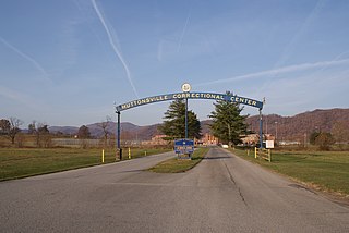
Huttonsville Correctional Center is a prison located near Huttonsville in Randolph County, West Virginia. It was created by an act of the Legislature in 1937 to relieve overcrowding at the West Virginia State Penitentiary. It remained a branch of the parent institution until 1947, at which time the Legislature established it as a separate entity – the West Virginia Medium Security Prison. In 1970, the center received its current name by legislative act. Huttonsville Correctional Center has been in operation since 1939 and is the oldest facility in the state.
The Potomac Highlands of West Virginia centers on five West Virginian counties in the upper Potomac River watershed in the western portion of the state's Eastern Panhandle, bordering Maryland and Virginia. Because of geographical proximity, similar topography and landscapes, and shared culture and history, the Potomac Highlands region also includes Pocahontas, Randolph, and Tucker counties, even though they are in the Monongahela River or New River watersheds and not that of the Potomac River.

Smoke Hole Caverns (SHC) is a picturesque show cave in Grant County in West Virginia's Eastern Panhandle.
Elleber Ridge is the name of a ridge in the Allegheny Mountains of West Virginia and it is also the name of the mountain's summit, Elleber Knob (4,595 ft). It is located in the eastern portion of Pocahontas County near the Virginia state line. The ridge and summit are located entirely in the Monongahela National Forest. Rattlesnake Trail runs from the base of the mountain to Elleber Knob. The summit is also accessible via Elleber Sods Road, which is maintained by the National Forest.
Lunice Creek is a 7.3-mile-long (11.7 km) tributary of the South Branch Potomac River, belonging to the Potomac River and Chesapeake Bay watersheds. The creek is located in Grant County, West Virginia. Lunice Creek is created by its North and South Forks and empties into the South Branch at Petersburg.
The Gastown riot, known also in the plural as Gastown riots, also known as "The Battle of Maple Tree Square", occurred in Vancouver, British Columbia, Canada, on August 7, 1971. Following weeks of arrests by undercover drug squad members in Vancouver as part of a special police operation directed by City hall, police broke up a protest smoke-in in the Gastown neighbourhood. The smoke-in was organized by the Youth International Party against the use of undercover agents and in favour of the legalization of marijuana. Of around two thousand protesters, 79 were arrested and 38 were charged.
Mount Blanchet Provincial Park is a provincial park in British Columbia, Canada, located on the west side of the southern end of Takla Lake, north of Smithers.
Crawleyville is an unincorporated community located along the Wabash River in Wabash Township in Gibson County. In the early 1900s, Crawleyville was an active community of farmers and fishermen.
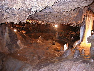
Seneca Caverns is a karst show cave in Germany Valley near Riverton, West Virginia, USA. It has been commercially presented since 1930. The largest room inside the cave is the Teter Hall, which is 60 feet tall by 60 feet wide in some areas.
Ugly Mountain is a summit in Pendleton County, West Virginia, in the United States. With an elevation of 2,598 feet (792 m), Ugly Mountain is the 507th highest summit in the state of West Virginia.
Socrates Mountain is a summit in Pendleton County, West Virginia, in the United States. With an elevation of 3,386 feet (1,032 m), Socrates Mountain is the 219th highest summit in the state of West Virginia.
Burner Mountain is a summit in West Virginia, in the United States. With an elevation of 4,295 feet (1,309 m), it is the 56th highest summit in the state of West Virginia.
Evick Knob is a summit in West Virginia, in the United States. With an elevation of 2,667 feet (813 m), Evick Knob is the 489th highest summit in the state of West Virginia.
Harding is an unincorporated community in Randolph County, in the U.S. state of West Virginia.
Michael Mountain is a summit in West Virginia, in the United States. With an elevation of 3,678 feet (1,121 m), Michael Mountain is the 164th highest summit in the state of West Virginia.
Paddy Knob is a summit in Virginia and West Virginia, in the United States. With an elevation of 4,478 feet (1,365 m), Paddy Knob is the 29th highest summit in the state of West Virginia, and the 14th highest in Virginia.
See All is a summit in West Virginia, in the United States. With an elevation of 3,166 feet (965 m), See All is the 294th highest summit in the state of West Virginia.
Sully is an unincorporated community in Randolph County, in the U.S. state of West Virginia.


