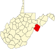
Lunice Creek is a 7.3-mile-long (11.7 km) tributary of the South Branch Potomac River, belonging to the Potomac River and Chesapeake Bay watersheds. The creek is located in Grant County, West Virginia. Lunice Creek is created by its North and South Forks and empties into the South Branch at Petersburg.
Bergoo is a census-designated place (CDP) in Webster County, West Virginia, United States. As of the 2010 census, its population was 94. Bergoo lies at the confluence of the Elk River and Leatherwood Creek. Bergoo was formerly known as Leatherwood, taking its name from the creek.
Tilhance Creek is a 10.4-mile-long (16.7 km) tributary stream of Back Creek in Berkeley County of West Virginia's Eastern Panhandle.

Elkhorn is an unincorporated community in McDowell County, West Virginia, United States. Elkhorn lies on U.S. Route 52 and takes its name from the creek that flows through the community.

Uneeda is an unincorporated community on the Pond Fork River in Boone County in the U.S. state of West Virginia. The town lies along West Virginia Route 85.

Virginia State Route 311 and West Virginia Route 311 are adjoining state highways in the U.S. states of Virginia and West Virginia. The two state highways together run 58.7 miles (94.5 km) from U.S. Route 11 in Salem, Virginia north to Interstate 64 and U.S. Route 60 near White Sulphur Springs, West Virginia. The two Virginia portions of Route 311 are maintained by the Virginia Department of Transportation, with the exception of the city-maintained portion within Salem. The West Virginia segments are maintained by the West Virginia Division of Highways.

Seneca Creek is a 19.6-mile-long (31.5 km) tributary of the North Fork of the South Branch of the Potomac River located entirely within Pendleton County, West Virginia, USA.

State Route 16 is a primary state highway in the southwest part of the U.S. state of Virginia. It runs from the North Carolina border at North Carolina Highway 16 north to the West Virginia border at West Virginia Route 16, passing through the towns of Troutdale, Marion, and Tazewell. Highway 16 is part of a three-state route 16 that connects the Charlotte region with northwestern West Virginia.
Sandyville is an unincorporated community in north central Jackson County, West Virginia, United States. It lies close to the left fork of Sandy Creek, nestled in the hills between Ravenswood and Ripley. It has a population of 1,721 and an average household income of $41,122.
Branchland is an unincorporated community in western Lincoln County, West Virginia, United States. It lies along West Virginia Route 10, southwest of the town of Hamlin, the county seat of Lincoln County. Its elevation is 597 feet (182 m). It has a post office with the ZIP code 25506. Raccoon Creek Road is one of the more popular ways of transportation through the area. Branchland Post Office serves addresses within Sheridan Magisterial District of Lincoln County as well as addresses in southern Cabell County and eastern Wayne County, West Virginia.
Millwood is an unincorporated community in northwestern Jackson County, West Virginia, United States, along the Ohio River at the mouth of Mill Creek. It lies along West Virginia Routes 2 and 62 northwest of the city of Ripley, the county seat of Jackson County. Its elevation is 577 feet (176 m). Although Millwood is unincorporated, it has a post office, with the ZIP code of 25262.
Belva is an unincorporated community and census-designated place in west Nicholas County and north Fayette County, West Virginia, United States; while the CDP only includes the Nicholas County portion, the Fayette County portion is considered part of the community. The town is situated at the bottomland surrounding the convergence of Bells Creek with Twentymile Creek and, subsequently, Twenty Mile Creek with the Gauley River. Belva is also the location of the convergence of two state highways: West Virginia Route 16 and West Virginia Route 39.
Red Creek is an unincorporated community in Tucker County, West Virginia, United States. Red Creek is located on West Virginia Route 72, 12 miles (19 km) southeast of Parsons. Red Creek has a post office with ZIP code 26289. Originally called Flanangan Hill after early settler Ebenezer Flanagan, the community was named Red Creek by the community's first postmaster William Raines. Being a Democrat, Raines refused to name the post office after the Republican Flanagan family, and thus named it for a nearby creek. The Red Creek post office was established in 1856.
Dry Creek is an unincorporated community in Raleigh County, West Virginia, United States. Dry Creek is located on West Virginia Route 3 16 miles (26 km) west-northwest of Beckley. Dry Creek has a post office with ZIP code 25062.
Elk Run Junction is an unincorporated community in Boone County, West Virginia, United States.
Halcyon is an unincorporated community located on the West Fork of Big Harts Creek in Logan and Lincoln counties, West Virginia, United States.
Brushy Creek is an unincorporated community in Anderson County, located in the U.S. state of Texas. According to the Handbook of Texas, the community had a population of 50 in 2000. It is located within the Palestine, Texas micropolitan area.

The Walker Mountain Cluster is a region in the Jefferson National Forest recognized by The Wilderness Society for its diversity of habitats extending along Walker Mountain. The mountain, part of the Appalachian Mountains in southwest Virginia, borders the western side of the Great Valley of Virginia. Interstate 81 traverses the Great Valley as it takes travelers between Tennessee and West Virginia.
The Kimberling Creek Cluster is a region in the Jefferson National Forest recognized by The Wilderness Society for its diversity of habitats extending along parts of Brushy and Hogback Mountains. Kimberling Creek, with headwaters in the cluster, flows into Big Walker Creek, a tributary of the New River.


