St. Albans, West Virginia | |
---|---|
Coordinates: 38°22′49″N81°49′11″W / 38.38028°N 81.81972°W | |
Country | United States |
State | West Virginia |
County | Kanawha |
Government | |
• Mayor | David Scott James [1] |
Area | |
• Total | 3.69 sq mi (9.56 km2) |
• Land | 3.62 sq mi (9.36 km2) |
• Water | 0.08 sq mi (0.20 km2) |
Elevation | 610 ft (186 m) |
Population | |
• Total | 10,861 |
• Estimate (2021) [3] | 10,635 |
• Density | 2,743.57/sq mi (1,059.34/km2) |
Time zone | UTC-5 (Eastern (EST)) |
• Summer (DST) | UTC-4 (EDT) |
ZIP Code | 25177 [4] |
Area code | 304 |
FIPS code | 54-71212 |
GNIS feature ID | 1555553 [5] |
Website | www.stalbanswv.com |
St. Albans is a city in western Kanawha County, West Virginia, United States, at the confluence of the Kanawha and Coal rivers. The population was 10,861 at the 2020 census. [3] It is part of the Charleston metropolitan area.
St. Albans was laid out in 1816. Originally, it was known as Philippi, after Philip Thompson, an early settler, the name afterwards being changed to Colesmouth due to the area and river being discovered by Samuel Cole. The city was then incorporated as Kanawha City in 1868. The town was renamed in 1872 by H.C. Parsons of the C & O Railroad in honor of his birthplace in St. Albans, Vermont, which is itself named after St. Albans in Hertfordshire, England. [6] The latter town is named for St. Alban, believed to have been the first British Christian martyr.
According to the United States Census Bureau, the city has a total area of 3.70 square miles (9.58 km2), of which 3.62 square miles (9.38 km2) is land and 0.08 square miles (0.21 km2) is water. [7]
Census | Pop. | Note | %± |
---|---|---|---|
1900 | 816 | — | |
1910 | 1,209 | 48.2% | |
1920 | 2,825 | 133.7% | |
1930 | 3,254 | 15.2% | |
1940 | 3,558 | 9.3% | |
1950 | 9,870 | 177.4% | |
1960 | 15,103 | 53.0% | |
1970 | 14,356 | −4.9% | |
1980 | 12,402 | −13.6% | |
1990 | 11,194 | −9.7% | |
2000 | 11,567 | 3.3% | |
2010 | 11,044 | −4.5% | |
2020 | 10,861 | −1.7% | |
2021 (est.) | 10,635 | [3] | −2.1% |
U.S. Decennial Census [8] |
As of the census [9] of 2010, there were 11,044 people, 4,969 households, and 3,073 families living in the city. The population density was 3,050.8 inhabitants per square mile (1,177.9/km2). There were 5,436 housing units at an average density of 1,501.7 per square mile (579.8/km2). The racial makeup of the city was 94.0% White, 3.4% African American, 0.3% Native American, 0.5% Asian, 0.3% from other races, and 1.6% from two or more races. Hispanic or Latino of any race were 0.8% of the population.
There were 4,969 households, of which 25.7% had children under the age of 18 living with them, 45.4% were married couples living together, 12.1% had a female householder with no husband present, 4.3% had a male householder with no wife present, and 38.2% were non-families. 33.7% of all households were made up of individuals, and 16.5% had someone living alone who was 65 years of age or older. The average household size was 2.21 and the average family size was 2.79.
The median age in the city was 45 years. 19.5% of residents were under the age of 18; 6.5% were between the ages of 18 and 24; 23.9% were from 25 to 44; 29.4% were from 45 to 64; and 20.6% were 65 years of age or older. The gender makeup of the city was 46.9% male and 53.1% female.
As of the census of 2000, there were 11,567 people, 5,185 households, and 3,390 families living in the city. The population density was 3,196.0 people per square mile (1,233.7/km2). There were 5,467 housing units at an average density of 1,510.5 per square mile (583.1/km2). The racial makeup of the city was 95.37% White, 2.84% African American, 0.13% Native American, 0.43% Asian, 0.18% from other races, and 1.05% from two or more races. Hispanic or Latino of any race were 0.63% of the population.
There were 5,185 households, out of which 23.5% had children under the age of 18 living with them, 51.6% were married couples living together, 10.6% had a female householder with no husband present, and 34.6% were non-families. 31.4% of all households were made up of individuals, and 17.1% had someone living alone who was 65 years of age or older. The average household size was 2.21 and the average family size was 2.75.
In the city, the population was spread out, with 19.2% under the age of 18, 6.8% from 18 to 24, 25.2% from 25 to 44, 25.2% from 45 to 64, and 23.6% who were 65 years of age or older. The median age was 44 years. For every 100 females, there were 85.6 males. For every 100 females age 18 and over, there were 81.5 males.
The median income for a household in the city was $37,130, and the median income for a family was $47,913. Males had a median income of $35,978 versus $25,030 for females. The per capita income for the city was $19,806. About 4.9% of families and 8.2% of the population were below the poverty line, including 12.3% of those under age 18 and 7.2% of those age 65 or over.
The Kanawha Valley is served by Kanawha Valley Regional Transportation Authority (KRT).
Kanawha County is a county in the U.S. state of West Virginia. As of the 2020 census, the population was 180,745, making it West Virginia's most populous county. The county seat is Charleston, which is also the state capital and most populous city. Kanawha County is part of the Charleston, WV Metropolitan Statistical Area.
Odenville is a city in St. Clair County, Alabama, United States. It incorporated in 1914. At the 2010 census the population was 3,585, up from 1,131 in 2000. It annexed the former town of Branchville in 2007. Odenville annexed a portion of Springville in 2015 due to Springville not running water to some of its residences.
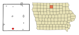
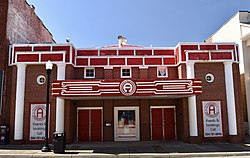
Kanawha is a city in Hancock County, Iowa, United States. The population was 658 at the time of the 2020 census.
Louisburg is a city in Miami County, Kansas, United States. As of the 2020 census, the population of the city was 4,969.
Watervliet is a city in Berrien County in the U.S. state of Michigan. Located in the northeastern part of the county, the population was 1,669 at the 2020 census. Mostly a rural farming community, the name comes from the Dutch for "where the waters meet." The city is surrounded by Watervliet Charter Township but is administered autonomously.
St. Bernard or Saint Bernard is a village in Hamilton County, Ohio, United States. It is an enclave and suburb of Cincinnati. The population was 4,070 at the 2020 census.
Sand Fork is a town in Gilmer County, West Virginia, United States. The population was 182 at the 2020 census. It is located along the Little Kanawha River, at the mouth of the Sand Fork.
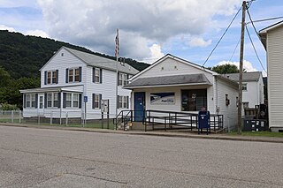
Belle is a town in Kanawha County, West Virginia, United States, situated along the Kanawha River. The population was 1,171 at the 2020 census. Belle was incorporated on December 13, 1958, by the Kanawha County Circuit Court. It is the home of the Belle Bulldogs Elementary School.
Chesapeake is a town in Kanawha County, West Virginia, United States. The population was 1,336 at the 2020 census. The town is situated on the Kanawha River.
Dunbar is a city in Kanawha County, West Virginia, United States, situated along the Kanawha River. The population was 7,479 at the 2020 census.
Pinch is a census-designated place (CDP) in Kanawha County, West Virginia, United States. The population was 3,262 at the 2010 census.
Pratt is a town in Kanawha County, West Virginia, United States, along the Kanawha River. The population was 482 at the 2020 census.
Alum Creek is a census-designated place (CDP) in Kanawha and Lincoln counties along the Coal River in the U.S. state of West Virginia. It includes the unincorporated communities of Alum Creek, Forks of Coal, and Priestley. The CDP had a population of 1,749 at the 2010 census, down from 1,839 at the 2000 census.
Eleanor is a town in Putnam County, West Virginia, United States, along the Kanawha River. Its population was 1,548 at the 2020 census. It is part of the Huntington–Ashland metropolitan area. The town, named for Eleanor Roosevelt, was established as a New Deal project in the 1930s like other Franklin D. Roosevelt towns around the nation.
Clearwater is a city in Stearns and Wright counties in the U.S. state of Minnesota. The population was 1,922 at the 2020 census. Most of the city lies within Wright County.
Montgomery is a city in West Virginia, along the Kanawha River. Most of the city is in Fayette County, with the remainder in Kanawha County. The population was 1,280 at the 2020 census.
Smithers is a city in Fayette and Kanawha counties in the U.S. state of West Virginia. Located along the Kanawha River, it lies almost entirely in Fayette County. The population was 751 at the 2020 census. The city most likely takes its name from Smithers Creek. The small river city is noted for having a rich cultural history related to both its coal mining and Italian-American heritages.
Nitro is a city in Kanawha and Putnam counties in the U.S. state of West Virginia. It takes its name from a World War I era nitrocellulose plant. The population was 6,618 according to the 2020 census. It is part of the Charleston metropolitan area.
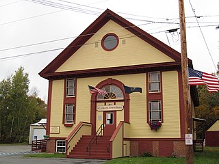
St. Albans is a town in Somerset County, Maine, United States. The population was 2,045 at the 2020 census.
Tornado, also called Upper Falls, is a census-designated place (CDP) in Kanawha County, West Virginia, United States.