White Sulphur Springs, West Virginia

Last updated

White Sulphur Springs, West Virginia
2008-0831-TheGreenbrier-North.jpg
Nickname: 
Spa City
Motto: 
Home of the Greenbrier Resort
Greenbrier County West Virginia Incorporated and Unincorporated areas White Sulphur Springs Highlighted.svg
Location of White Sulphur Springs in Greenbrier County, West Virginia
Coordinates: 37°47′54″N80°18′01″W / 37.79833°N 80.30028°W / 37.79833; -80.30028
Country United States
State West Virginia
County Greenbrier
Government
  MayorLloyd Haynes
  City CouncilBobby Sams
Bruce Bowling
GP Parker
Lynn Swann
Area
[1]
  Total1.90 sq mi (4.91 km2)
  Land1.87 sq mi (4.85 km2)
  Water0.02 sq mi (0.06 km2)
Elevation
[2]
1,850 ft (560 m)
Population
 (2020) [3]
  Total2,231
  Estimate 
(2021) [3]
2,198
  Density1,255.21/sq mi (484.56/km2)
Time zone UTC-5 (Eastern (EST))
  Summer (DST) UTC-4 (EDT)
ZIP code
24986
Area code(s) 304, 681
FIPS code 54-86812 [4]
GNIS feature ID2390673 [2]
Website Official website

White Sulphur Springs is a city in Greenbrier County in southeastern West Virginia, United States. The population was 2,231 at the 2020 census. [3] The city emblem consists of five dandelion flowers and the citizens celebrate spring with an annual Dandelion Festival. [5]

Contents

History

White Sulphur Springs grew in the first half of the nineteenth century as the southern "Queen of the Watering Places". The springs resort first became the standard summer destination for wealthy Virginia Low Country residents seeking reprieve from heat, humidity, and disease of the "sickly season". As its popularity increased and it gained status as a socially exclusive site, the springs attracted elite guests from all over.

The resort, now known as The Greenbrier, remains one of the country's most luxurious and exclusive resorts. For many years, Sam Snead was the resort's golf pro and later golf pro emeritus. The resort has another significant place in golf history; in 1979, it hosted the first Ryder Cup to feature the current competitive setup of the United States and European sides. Golf in the United States began near White Sulphur Springs when the Montague family founded Oakhurst Links in 1884, making it the oldest organized golf club in the country. In 2010, the Greenbrier hosted the inaugural PGA Greenbrier Classic. [6]

In 1992 The Washington Post reported that, during the Cold War, the resort had been the site of a "bunker", the Emergency Relocation Center known as Project Greek Island, which was intended to house and protect the U.S. Congress in the event of a nuclear attack. [7]

In June 2016, there was a historic severe flood in West Virginia that impacted White Sulphur Springs. [8] [9] [10]

The Greenbrier has also served as a training camp location for the Houston Texans, New Orleans Saints, Cleveland Browns, Arizona Cardinals, New England Patriots, and San Francisco 49ers. [11]

Geography

White Sulphur Springs is located along Howard Creek and is served by I-64 and US Route 60. [12]

According to the United States Census Bureau, the city has a total area of 1.98 square miles (5.13 km2), of which 1.95 sq mi (5.05 km2) is land and 0.03 sq mi (0.08 km2) is water. [13] It is also within the National Radio Quiet Zone. Services with AT&T, Verizon, Sprint, and U.S. Cellular is allowed within the area under lower tower frequencies.

Climate

White Sulphur Springs has a humid continental climate (Koppen Dfa).

Climate data for White Sulphur Springs, West Virginia (1991–2020 normals, extremes 1895–present)
MonthJanFebMarAprMayJunJulAugSepOctNovDecYear
Record high °F (°C)77
(25)
79
(26)
88
(31)
96
(36)
96
(36)
99
(37)
102
(39)
100
(38)
103
(39)
93
(34)
82
(28)
77
(25)
103
(39)
Mean daily maximum °F (°C)40.7
(4.8)
44.7
(7.1)
53.3
(11.8)
65.4
(18.6)
72.7
(22.6)
79.1
(26.2)
82.7
(28.2)
81.9
(27.7)
76.6
(24.8)
66.1
(18.9)
54.6
(12.6)
44.4
(6.9)
63.5
(17.5)
Daily mean °F (°C)30.8
(−0.7)
33.7
(0.9)
40.9
(4.9)
51.1
(10.6)
59.7
(15.4)
67.2
(19.6)
71.1
(21.7)
70.3
(21.3)
64.2
(17.9)
52.8
(11.6)
41.8
(5.4)
34.4
(1.3)
51.5
(10.8)
Mean daily minimum °F (°C)20.9
(−6.2)
22.8
(−5.1)
28.4
(−2.0)
36.9
(2.7)
46.7
(8.2)
55.3
(12.9)
59.6
(15.3)
58.7
(14.8)
51.9
(11.1)
39.4
(4.1)
29.1
(−1.6)
24.4
(−4.2)
39.5
(4.2)
Record low °F (°C)−19
(−28)
−16
(−27)
−8
(−22)
12
(−11)
21
(−6)
30
(−1)
36
(2)
36
(2)
26
(−3)
9
(−13)
−1
(−18)
−34
(−37)
−34
(−37)
Average precipitation inches (mm)3.05
(77)
2.79
(71)
2.70
(69)
3.66
(93)
4.52
(115)
3.71
(94)
4.15
(105)
3.34
(85)
3.58
(91)
2.70
(69)
2.57
(65)
3.26
(83)
41.03
(1,042)
Average snowfall inches (cm)5.6
(14)
6.3
(16)
3.4
(8.6)
0.3
(0.76)
0.0
(0.0)
0.0
(0.0)
0.0
(0.0)
0.0
(0.0)
0.0
(0.0)
0.1
(0.25)
0.4
(1.0)
2.0
(5.1)
18.1
(46)
Average precipitation days (≥ 0.01 in)12.611.312.412.214.413.412.612.29.89.89.612.1142.4
Average snowy days (≥ 0.1 in)3.22.91.60.30.00.00.00.00.00.10.42.310.8
Source: NOAA [14] [15]

Demographics

Historical population
CensusPop.Note
1910 338
1920 837147.6%
1930 1,48477.3%
1940 2,09341.0%
1950 2,64326.3%
1960 2,6761.2%
1970 2,8697.2%
1980 3,37117.5%
1990 2,779−17.6%
2000 2,595−6.6%
2010 2,444−5.8%
2020 2,231−8.7%
2021 (est.)2,198 [3] −1.5%
U.S. Decennial Census [16]

2010 census

At the 2010 census there were 2,444 people, 1,131 households, and 647 families living in the city. The population density was 1,253.3 inhabitants per square mile (483.9/km2). There were 1,414 housing units at an average density of 725.1/sq mi (280.0/km2). The racial makeup of the city was 83.7% White, 13.5% African American, 0.2% Native American, 0.3% Asian, 0.5% from other races, and 1.8% from two or more races. Hispanic or Latino of any race were 1.3%. [17]

Of the 1,131 households, 23.9% had children under the age of 18 living with them, 39.6% were married couples living together, 13.0% had a female householder with no husband present, 4.6% had a male householder with no wife present, and 42.8% were non-families. 37.0% of households were one person and 16.2% were one person aged 65 or older. The average household size was 2.10 and the average family size was 2.72.

The median age was 45.8 years. 17.9% of residents were under the age of 18; 7.8% were between the ages of 18 and 24; 22.9% were from 25 to 44; 28.4% were from 45 to 64; and 22.8% were 65 or older. The gender makeup of the city was 46.1% male and 53.9% female.

2000 census

At the 2000 census there were 2,315 people, 1,127 households, and 648 families living in the city. The population density was 1,179.5 people per square mile (456.0/km2). There were 1,354 housing units at an average density of 689.9 per square mile (266.7/km2). The racial makeup of the city was 82.55% White, 14.95% African American, 0.09% Native American, 0.26% Asian, 0.26% from other races, and 1.90% from two or more races. Hispanics or Latinos of any race were 1.04%. [4]

Of the 1,127 households 21.6% had children under the age of 18 living with them, 42.7% were married couples living together, 12.1% had a female householder with no husband present, and 42.5% were non-families. 38.6% of households were one person and 17.7% were one person aged 65 or older. The average household size was 2.05 and the average family size was 2.72.

The age distribution was 19.0% under the age of 18, 7.0% from 18 to 24, 25.8% from 25 to 44, 27.4% from 45 to 64, and 20.8% 65 or older. The median age was 44 years. For every 100 females, there were 82.0 males. For every 100 females age 18 and over, there were 81.4 males.

The median household income was $26,694 and the median family income was $35,450. Males had a median income of $28,566 versus $19,868 for females. The per capita income for the city was $14,822. About 15.7% of families and 17.6% of the population were below the poverty line, including 23.9% of those under age 18 and 8.5% of those age 65 or over.

Education

Transportation

Amtrak, the national passenger rail service, provides service to White Sulphur Springs three times a week via the Cardinal route. The station is located at the entrance to The Greenbrier.

The Alleghany Subdivision of the main line of the former Chesapeake and Ohio Railroad (now part of CSX) runs through White Sulphur Springs. At one time in its history it was part of the limestone flux cargo route from Hinton, West Virginia to Clifton Forge, Virginia. Its affectionate nickname was "The Gravel Gertie" after the Dick Tracy character.[ citation needed ]

Buildings and structures

In 1987 the White Sulphur Springs Library was rebuilt from the old community house. The library is being redeveloped as an educational resource and one of the hearts of the town. [18] The building containing the library was renamed the Katherine Coleman Johnson Building in 2017, after White Sulphur Springs native and NASA scientist Katherine Coleman Johnson. [19]

Related Research Articles

<span class="mw-page-title-main">Summers County, West Virginia</span> County in West Virginia, United States

Summers County is a county located in the U.S. state of West Virginia. As of the 2020 census, the population was 11,959. Its county seat is Hinton. The county was created by an act of the West Virginia Legislature on February 27, 1871, from parts of Fayette, Greenbrier, Mercer and Monroe counties and named in honor of George W. Summers (1804–68).

<span class="mw-page-title-main">Monroe County, West Virginia</span> County in West Virginia, United States

Monroe County is a county in the U.S. state of West Virginia. As of the 2020 census, the population was 12,376. Its county seat is Union.

<span class="mw-page-title-main">Greenbrier County, West Virginia</span> County in West Virginia, United States

Greenbrier County is a county in the U.S. state of West Virginia. As of the 2020 census, the population was 32,977. Its county seat is Lewisburg. The county was formed in 1778 from Botetourt and Montgomery counties in Virginia.

<span class="mw-page-title-main">Bath County, Virginia</span> County in Virginia, United States

Bath County is a United States county on the central western border of the Commonwealth of Virginia, on the West Virginia state line. As of the 2020 census, the population was 4,209, the second-least populous county in Virginia. Bath's county seat is Warm Springs.

<span class="mw-page-title-main">Oak Hill, West Virginia</span> City in West Virginia, United States

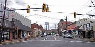
Oak Hill is a city in Fayette County, West Virginia, United States. The population was 8,179 at the 2020 census. It is part of the Beckley metropolitan area.

<span class="mw-page-title-main">Glenville, West Virginia</span> Town in West Virginia, United States

Glenville is a town in and the county seat of Gilmer County, West Virginia, United States, along the Little Kanawha River. The population was 1,128 at the 2020 census. It is the home of Glenville State University.

<span class="mw-page-title-main">Falling Spring, West Virginia</span> Town in West Virginia, United States

Falling Spring is a town in Greenbrier County, West Virginia, United States. It is also known as Renick from the name of its post office. The population was 171 at the 2020 census.

<span class="mw-page-title-main">Lewisburg, West Virginia</span> City in West Virginia, United States

Lewisburg is a city in and the county seat of Greenbrier County, West Virginia, United States. The population was 3,930 at the 2020 census.

<span class="mw-page-title-main">Quinwood, West Virginia</span> Town in West Virginia, United States

Quinwood is a town and former coal town in Greenbrier County, West Virginia, United States. The population was 220 at the 2020 census.

<span class="mw-page-title-main">Ronceverte, West Virginia</span> City in West Virginia, United States

Ronceverte is a city in Greenbrier County, West Virginia, United States, on the Greenbrier River. The population was 1,572 at the 2020 census.

<span class="mw-page-title-main">Rupert, West Virginia</span> Town in West Virginia, United States

Rupert is a town in Greenbrier County, West Virginia, United States. The population was 881 at the 2020 census.

<span class="mw-page-title-main">New Cumberland, West Virginia</span> City in West Virginia, United States

New Cumberland is a city in and the county seat of Hancock County, West Virginia, United States, along the Ohio River. The population was 1,020 as of the 2020 census. It is part of the Weirton–Steubenville metropolitan area and is located near the Mountaineer Casino, Racetrack and Resort.

<span class="mw-page-title-main">Leon, West Virginia</span> Town in West Virginia, United States

Leon is a town in Mason County, West Virginia, United States, situated along the Kanawha River. The population was 137 at the 2020 census. It is part of the Point Pleasant, WV–OH Micropolitan Statistical Area.

<span class="mw-page-title-main">Westover, West Virginia</span> City in West Virginia

Westover is a city in Monongalia County, West Virginia, United States, along the Monongahela River. The population was 3,995 at the 2020 census. It is part of the Morgantown metropolitan area.

<span class="mw-page-title-main">Peterstown, West Virginia</span> Town in West Virginia, United States

Peterstown is a town in Monroe County, West Virginia, United States. The population was 456 at the 2020 census.

<span class="mw-page-title-main">Union, West Virginia</span> Town in West Virginia, United States

Union is a town in Monroe County, West Virginia, United States. Union’s population is 427 as of 2020. It is the county seat of Monroe County.

<span class="mw-page-title-main">Durbin, West Virginia</span> Town in West Virginia, United States

Durbin is a town in Pocahontas County, West Virginia, United States. The population was 235 at the 2020 census.

<span class="mw-page-title-main">Shady Spring, West Virginia</span> Census-designated place in West Virginia, United States

Shady Spring is a census-designated place (CDP) in Raleigh County, West Virginia, United States. The population was 2,998 at the 2010 census. It is a residential community, with a low crime rate.

<span class="mw-page-title-main">Hinton, West Virginia</span> City in West Virginia, United States

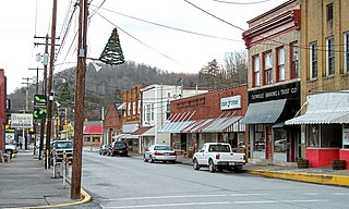
Hinton is a city in and the county seat of Summers County, West Virginia, United States. The population was 2,266 at the 2020 census. Hinton was established in 1873 and chartered in 1897. Hinton was named after John "Jack" Hinton, the original owner of the town site. Much of Hinton's downtown was placed on the National Register of Historic Places in 1984. In 1994, part of Paramount's film Lassie was shot in Hinton. In the 1990s, Hinton's downtown experienced economic decline after a hospital moved away and Interstate 64 bypassed the town. In 2007, Hinton native and business owner Ken Allman founded MountainPlex Properties, which since then has worked to preserve and revitalize the Hinton Historic District.

<span class="mw-page-title-main">Webster Springs, West Virginia</span> Town in West Virginia, United States

Addison, commonly known as Webster Springs, is a town in and the county seat of Webster County, West Virginia, United States. Although it was incorporated as Addison in 1892, it is more frequently referred to as Webster Springs, the name of the town's post office. It was named for Addison McLaughlin, upon whose land the town was originally laid out. The population was 731 at the 2020 census.

References

  1. "2019 U.S. Gazetteer Files". United States Census Bureau. Retrieved August 7, 2020.
  2. 1 2 U.S. Geological Survey Geographic Names Information System: White Sulphur Springs, West Virginia
  3. 1 2 3 4 "City and Town Population Totals: 2020-2021". Census.gov. US Census Bureau. Retrieved July 3, 2022.
  4. 1 2 "U.S. Census website". United States Census Bureau . Retrieved January 31, 2008.
  5. "Welcome to Main Street White Sulphur Springs...Make it home". Wssmainstreet.org. Archived from the original on 4 June 2010. Retrieved 3 July 2010.
  6. "2010 The Greenbrier Classic results - PGA Golf Leaderboard". www.foxsports.com. Retrieved June 28, 2018.
  7. "Greenbrier", The Washington Post, 25 July 1992
  8. West Virginia flooding leaves at least 23 dead; CNN; June 25, 2016.
  9. Flooding in Rainelle, Richwood, White Sulphur Springs and surrounding areas; Register Herald; June 24, 2016.
  10. 10 images and video showing devastation from historic flooding in West Virginia; ABC7 tv; June 24, 2016.
  11. "Greenbrier Sports Performance Center". www.greenbrier.com. Retrieved March 13, 2024.
  12. White Sulfur Springs,WV, 7.5 Minute Topographic Quadrangle, USGS, 1995
  13. "US Gazetteer files 2010". United States Census Bureau . Retrieved January 24, 2013.
  14. "NowData – NOAA Online Weather Data". National Oceanic and Atmospheric Administration. Retrieved July 1, 2021.
  15. "Station: White Sulphur Springs, WV". U.S. Climate Normals 2020: U.S. Monthly Climate Normals (1991-2020). National Oceanic and Atmospheric Administration. Retrieved July 1, 2021.
  16. "Census of Population and Housing". Census.gov. Retrieved June 4, 2015.
  17. "U.S. Census website". United States Census Bureau . Retrieved January 24, 2013.
  18. White Sulphur Springs Public Library
  19. REPORTER, Tina Alvey REGISTER-HERALD. "Katherine Johnson marks 99th birthday in Spa City". Beckley Register-Herald. Retrieved June 28, 2018.