The following is a list of lists of the cities, towns and villages of the United States separated by state, territory or district name.

Belva is an unincorporated community and census-designated place in west Nicholas County and north Fayette County, West Virginia, United States; while the CDP only includes the Nicholas County portion, the Fayette County portion is considered part of the community. The town is situated at the bottomland surrounding the convergence of Bells Creek with Twentymile Creek and, subsequently, Twenty Mile Creek with the Gauley River. Belva is also the location of the convergence of two state highways: West Virginia Route 16 and West Virginia Route 39.
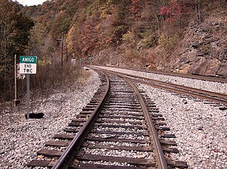
Amigo is an unincorporated community in Raleigh County, West Virginia, United States. The community is located on West Virginia Route 16 at the confluence of the Guyandotte River and Winding Gulf. The Amigo Post Office closed on 10/22/2011, it was established in 1915 The community most likely derives its name from the Amigo Coal Company.
Mahan is an unincorporated community in Fayette County, West Virginia, United States. Mahan is located off exit 66 on the West Virginia Turnpike.

Blaker Mills is an unincorporated community in Greenbrier County, West Virginia, United States. Blaker Mills is located on West Virginia Route 12 northwest of Alderson.
Nallen is an unincorporated community in Fayette and Nicholas counties, West Virginia, United States. Nallen is located along West Virginia Route 41 12 miles (19 km) south of Summersville. Nallen has a post office with ZIP code 26680.
Russellville is an unincorporated community in Fayette County, West Virginia, United States. Russellville is located along West Virginia Route 41 14.5 miles (23.3 km) south of Summersville.
Spring Dale is an unincorporated community in Fayette County, West Virginia, United States. Spring Dale is located on West Virginia Route 20 3 miles (4.8 km) northeast of Meadow Bridge. Spring Dale has a post office with ZIP code 25986.
Maplewood is an unincorporated community in Fayette County, West Virginia, United States. Maplewood is located on West Virginia Route 41 6.5 miles (10.5 km) northwest of Meadow Bridge.
Dothan is an unincorporated community in Fayette County, West Virginia, United States. Dothan is located on West Virginia Route 612 4 miles (6.4 km) west of Oak Hill. Dothan had a post office, which closed on October 5, 1991.
Surveyor is an unincorporated community in Raleigh County, West Virginia, United States. Surveyor is located on West Virginia Route 305 7 miles (11 km) west of Beckley. Surveyor has a post office with ZIP code 25932.
Burnwell is an unincorporated community in Kanawha County, West Virginia, United States. Burnwell is 10.5 miles (16.9 km) east-northeast of Sylvester.

Carlisle is an unincorporated community in Fayette County, West Virginia, United States. Carlisle is located on West Virginia Route 612 2 miles (3.2 km) southwest of Oak Hill.
Packsville is an unincorporated community in Raleigh County, West Virginia, United States. Packsville is located on the Little Marsh Fork 4.4 miles (7.1 km) south-southeast of Sylvester.
Beckwith is an unincorporated community in Fayette County, West Virginia, United States. Beckwith is located on West Virginia Route 16 and Laurel Creek 4.1 miles (6.6 km) northwest of Fayetteville. Beckwith had a post office, which closed on October 3, 1998. The community has the name of P. D. Beckwith.
Harvey is an unincorporated community in Fayette County, West Virginia, United States. Harvey is located on County Route 25 2.8 miles (4.5 km) south-southeast of Oak Hill.
Kilsyth is an unincorporated community in Fayette County, West Virginia, United States. Kilsyth is 1 mile (1.6 km) west-southwest of Mount Hope. Kilsyth had a post office, which opened on May 3, 1902, and closed on July 23, 2005.
Mead is an unincorporated community in Raleigh County, West Virginia, United States. Mead is located on County Route 33 and Stonecoal Creek 2.7 miles (4.3 km) east-northeast of Rhodell. Mead had a post office, which closed on June 10, 1989. It was also known as Vanwood.
Quinnimont is an unincorporated community in Fayette County, West Virginia, United States. Quinnimont is located on West Virginia Route 41 near the New River, 7.1 miles (11.4 km) east-southeast of Mount Hope. Quinnimont had a post office, which opened on February 23, 1874, and closed on February 1, 1997.


