Gassaway, West Virginia

Last updated

Gassaway, West Virginia
Gassaway West Virginia.jpg
Elk Street (West Virginia Route 4) in downtown Gassaway in 2007
Flag of Gassaway, West Virginia.svg
Braxton County West Virginia Incorporated and Unincorporated areas Gassaway Highlighted.svg
Location of Gassaway in Braxton County, West Virginia.
Coordinates: 38°40′15″N80°46′13″W / 38.67083°N 80.77028°W / 38.67083; -80.77028
Country United States
State West Virginia
County Braxton
MayorRichard Roach
Government
  Chief of PoliceMolly Carder
Area
[1]
  Total1.22 sq mi (3.15 km2)
  Land1.16 sq mi (2.99 km2)
  Water0.06 sq mi (0.16 km2)
Elevation
860 ft (262 m)
Population
 (2020) [2]
  Total769
  Estimate 
(2021) [2]
755
  Density732.47/sq mi (282.77/km2)
Time zone UTC-5 (Eastern (EST))
  Summer (DST) UTC-4 (EDT)
ZIP code
26624
Area code 304
FIPS code 54-30220 [3]
GNIS feature ID1539355 [4]
Website https://local.wv.gov/Gassaway/Pages/about.aspx

Gassaway is a town in Braxton County, West Virginia, United States. The population was 769 at the 2020 census. [2] Gassaway was incorporated in 1905 and named for Henry Gassaway Davis, the Democratic Party's nominee for Vice President of the United States in 1904. [5] The center of population of West Virginia is located approximately 7 miles (11 km) north of Gassaway. [6]

Contents

History

The town was originally created at the ends of two divisions of the Coal and Coke Railway, one originating in Charleston and the other originating in Elkins. Because of its central location, the area was an ideal place to build shops to facilitate the transition between the relatively flat Charleston division, which could operate with standard equipment, and the more hilly Elkins division of the Coal & Coke which required heavier engines. The town was laid out in 1904, and over the next decade, businesses and infrastructure such as hotels, a bank, stores, schools, a hospital, office buildings and churches appeared to serve the growing population. By 1915, the Coal & Coke Railway Company had completed work on a depot to facilitate passenger service to the town. [7] The Gassaway Depot still stands today and was listed on the National Register of Historic Places in 1994. [8]

Geography

Gassaway is located at 38°40′15″N80°46′13″W / 38.67083°N 80.77028°W / 38.67083; -80.77028 (38.670712, -80.770413), [9] along the Elk River. [10]

According to the United States Census Bureau, the town has a total area of 1.22 square miles (3.16 km2), of which 1.16 square miles (3.00 km2) is land and 0.06 square miles (0.16 km2) is water. [11]

Climate

The climate in this area is characterized by hot, humid summers and generally mild to freezing winters. According to the Köppen Climate Classification system, Gassaway has a humid subtropical climate, abbreviated "Cfa" on climate maps. [12]

Climate data for Gassaway, West Virginia (1991–2020 normals, extremes 1951–present)
MonthJanFebMarAprMayJunJulAugSepOctNovDecYear
Record high °F (°C)76
(24)
80
(27)
88
(31)
91
(33)
95
(35)
99
(37)
102
(39)
102
(39)
105
(41)
94
(34)
84
(29)
80
(27)
105
(41)
Mean maximum °F (°C)66.6
(19.2)
69.5
(20.8)
76.8
(24.9)
85.4
(29.7)
87.8
(31.0)
90.2
(32.3)
92.2
(33.4)
91.4
(33.0)
89.5
(31.9)
83.8
(28.8)
77.1
(25.1)
68.4
(20.2)
93.2
(34.0)
Mean daily maximum °F (°C)41.8
(5.4)
45.8
(7.7)
54.4
(12.4)
67.0
(19.4)
75.0
(23.9)
81.5
(27.5)
84.9
(29.4)
83.9
(28.8)
79.2
(26.2)
68.4
(20.2)
56.7
(13.7)
46.3
(7.9)
65.4
(18.6)
Daily mean °F (°C)31.7
(−0.2)
34.8
(1.6)
42.2
(5.7)
53.6
(12.0)
62.9
(17.2)
70.6
(21.4)
74.5
(23.6)
73.4
(23.0)
67.5
(19.7)
55.6
(13.1)
44.4
(6.9)
36.5
(2.5)
54.0
(12.2)
Mean daily minimum °F (°C)21.7
(−5.7)
23.8
(−4.6)
29.9
(−1.2)
40.2
(4.6)
50.9
(10.5)
59.6
(15.3)
64.2
(17.9)
62.8
(17.1)
55.9
(13.3)
42.8
(6.0)
32.0
(0.0)
26.6
(−3.0)
42.5
(5.8)
Mean minimum °F (°C)1.9
(−16.7)
6.9
(−13.9)
15.7
(−9.1)
25.9
(−3.4)
35.6
(2.0)
47.4
(8.6)
55.1
(12.8)
53.9
(12.2)
43.7
(6.5)
30.2
(−1.0)
19.8
(−6.8)
11.8
(−11.2)
−0.8
(−18.2)
Record low °F (°C)−22
(−30)
−14
(−26)
−3
(−19)
17
(−8)
25
(−4)
33
(1)
40
(4)
40
(4)
30
(−1)
14
(−10)
5
(−15)
−10
(−23)
−22
(−30)
Average precipitation inches (mm)3.55
(90)
3.25
(83)
4.23
(107)
4.10
(104)
4.99
(127)
5.08
(129)
6.44
(164)
4.72
(120)
3.47
(88)
3.73
(95)
3.40
(86)
4.01
(102)
50.97
(1,295)
Average snowfall inches (cm)5.4
(14)
4.1
(10)
3.3
(8.4)
0.2
(0.51)
0.0
(0.0)
0.0
(0.0)
0.0
(0.0)
0.0
(0.0)
0.0
(0.0)
0.0
(0.0)
0.8
(2.0)
3.5
(8.9)
17.3
(44)
Average precipitation days (≥ 0.01 in)15.713.814.313.914.313.513.411.310.010.712.215.8158.9
Average snowy days (≥ 0.1 in)4.53.41.50.30.00.00.00.00.00.00.62.412.7
Source: NOAA [13] [14]

Demographics

Historical population
CensusPop.Note
1910 1,086
1920 1,51839.8%
1930 1,6186.6%
1940 1,429−11.7%
1950 1,306−8.6%
1960 1,223−6.4%
1970 1,2532.5%
1980 1,225−2.2%
1990 946−22.8%
2000 901−4.8%
2010 9080.8%
2020 769−15.3%
2021 (est.)755 [2] −1.8%
U.S. Decennial Census [15]

2010 census

As of the census [16] of 2010, there were 908 people, 434 households, and 228 families living in the town. The population density was 782.8 inhabitants per square mile (302.2/km2). There were 496 housing units at an average density of 427.6 per square mile (165.1/km2). The racial makeup of the town was 98.6% White, 0.1% African American, 0.1% Native American, 0.3% Asian, and 0.9% from two or more races. Hispanic or Latino of any race were 0.1% of the population.

There were 434 households, of which 22.1% had children under the age of 18 living with them, 39.4% were married couples living together, 9.2% had a female householder with no husband present, 3.9% had a male householder with no wife present, and 47.5% were non-families. 41.0% of all households were made up of individuals, and 19.1% had someone living alone who was 65 years of age or older. The average household size was 2.09 and the average family size was 2.84.

The median age in the town was 44.5 years. 19.2% of residents were under the age of 18; 7.9% were between the ages of 18 and 24; 23.3% were from 25 to 44; 28.1% were from 45 to 64; and 21.4% were 65 years of age or older. The gender makeup of the town was 47.5% male and 52.5% female.

2000 census

As of the census [3] of 2000, there were 901 people, 420 households, and 243 families living in the town. The population density was 741.5 inhabitants per square mile (285.1/km2). There were 506 housing units at an average density of 416.4 per square mile (160.1/km2). The racial makeup of the town was 98.34% White, 0.55% African American, 0.55% Native American, 0.11% from other races, and 0.44% from two or more races. Hispanic or Latino of any race were 1.00% of the population.

There were 420 households, out of which 21.7% had children under the age of 18 living with them, 45.2% were married couples living together, 10.0% had a female householder with no husband present, and 42.1% were non-families. 38.8% of all households were made up of individuals, and 21.7% had someone living alone who was 65 years of age or older. The average household size was 2.15 and the average family size was 2.87.

In the town, the population dispersal was 20.0% under the age of 18, 6.5% from 18 to 24, 23.3% from 25 to 44, 25.0% from 45 to 64, and 25.2% who were 65 years of age or older. The median age was 45 years. For every 100 females, there were 82.4 males. For every 100 females age 18 and over, there were 79.8 males. The median income for a household in the town was $23,009, and the median income for a family was $31,667. Males had a median income of $28,125 versus $17,396 for females. The per capita income for the town was $15,965. About 10.8% of families and 13.9% of the population were below the poverty line, including 10.9% of those under age 18 and 16.9% of those age 65 or over.

Notable person

Related Research Articles

<span class="mw-page-title-main">Sycamore, Georgia</span> City in Georgia, United States

Sycamore is a city in Turner County, Georgia, United States. The population was 692 in 2020.

<span class="mw-page-title-main">Junior, West Virginia</span> Town in West Virginia, United States

Junior is a town in Barbour County, West Virginia, United States, situated along the Tygart Valley River. The population was 384 at the 2020 census.

<span class="mw-page-title-main">Burnsville, West Virginia</span> Town in West Virginia, United States

Burnsville is a town in Braxton County, West Virginia, United States, at the confluence of the Little Kanawha River and Saltlick Creek. The population was 401 at the 2020 census. Burnsville was incorporated in 1902 by the Circuit Court and named for Captain John Burns who operated the first sawmill in that section of the state and who established the town shortly after the close of the American Civil War. It was named "All West Virginia City" in 1976.

<span class="mw-page-title-main">Grantsville, West Virginia</span> Town in West Virginia, United States

Grantsville is a town in Calhoun County, West Virginia, United States. The population was 482 at the 2020 census. It is the county seat of Calhoun County. The town was established along the Little Kanawha River in 1865 and named for Ulysses S. Grant. Grantsville is home to Wayne Underwood Park, which includes a .25-mile-long (0.40 km) walking trail, and to the annual West Virginia Wood Festival.

<span class="mw-page-title-main">Man, West Virginia</span> Town in West Virginia, United States

Man is a town in Logan County, West Virginia, United States. The population was 772 at the 2020 census. The town is located along the Guyandotte River at the mouth of Buffalo Creek, which was the site of the 1972 Buffalo Creek Flood following a dam collapse. The name of the town reportedly derives from the last syllable of the surname of Ulysses Hinchman, who was a member of the House of Delegates from Logan County between 1866 and 1869.

<span class="mw-page-title-main">Henderson, West Virginia</span> Unincorporated Town in West Virginia, United States

Henderson is an unincorporated community and former town in Mason County, West Virginia, United States, at the confluence of the Ohio and Kanawha Rivers. The population was 231 at the 2020 census. It is part of the Point Pleasant, WV–OH Micropolitan Statistical Area. The town was incorporated in 1893 and named for Samuel Bruce Henderson, who owned the townsite at the time. The town was unincorporated following a public hearing on August 11, 2022.

<span class="mw-page-title-main">Granville, West Virginia</span> Town in West Virginia

Granville is a town in Monongalia County, West Virginia, United States. The population was 1,355 at the 2020 census. It is included in the Morgantown metropolitan area.

<span class="mw-page-title-main">Albright, West Virginia</span> Town in West Virginia, United States

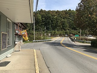
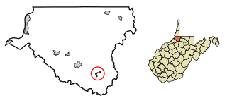
Albright is a town in central Preston County, West Virginia, United States, along the Cheat River. The population was 260 at the 2020 census. A former coal town, it is part of the Morgantown metropolitan area.

<span class="mw-page-title-main">Bruceton Mills, West Virginia</span> Town in West Virginia, United States

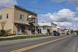
Bruceton Mills is a town in northern Preston County, West Virginia, United States, along Big Sandy Creek. The population was 64 at the 2020 census, making it the second-least populous town in West Virginia, after Thurmond. It is part of the Morgantown metropolitan area.

<span class="mw-page-title-main">Cairo, West Virginia</span> Town in West Virginia, United States

Cairo is a town in Ritchie County, West Virginia, United States, along West Virginia Route 31, the North Fork of the Hughes River, and the North Bend Rail Trail. The population was 174 at the 2020 census.

<span class="mw-page-title-main">Davis, West Virginia</span> Town in West Virginia, United States

Davis is a town in Tucker County, West Virginia, United States, situated along the Blackwater River. The population was 595 at the 2020 census.

<span class="mw-page-title-main">Hambleton, West Virginia</span> Town in West Virginia, United States

Hambleton is a town in Tucker County, West Virginia, United States. The population was 216 at the 2020 census. Hambleton was established in 1889, but not incorporated until 1905. It was named by then United States Senator Stephen B. Elkins in honor of a stockholder by this name in the West Virginia Central Railroad Company. The town was previously known as Hulings.

<span class="mw-page-title-main">Hendricks, West Virginia</span> Town in West Virginia, United States

Hendricks is a town in Tucker County, West Virginia, United States. The population was 226 at the 2020 census. The Blackwater River and the Dry Fork join at Hendricks to form the Black Fork, a principal tributary of the Cheat River.

<span class="mw-page-title-main">Thomas, West Virginia</span> City in West Virginia, United States

Thomas is a city and former coal town in Tucker County, West Virginia, United States. The population was 623 at the 2020 census.

<span class="mw-page-title-main">Middlebourne, West Virginia</span> Town in West Virginia, United States

Middlebourne is a town and the county seat of Tyler County, West Virginia, United States. The population was 715 at the 2020 census.

<span class="mw-page-title-main">Smithfield, West Virginia</span> Town in West Virginia, United States

Smithfield is a town in Wetzel County, West Virginia, United States. The population was 103 at the 2020 census.

<span class="mw-page-title-main">Oceana, West Virginia</span> Town in West Virginia, United States

Oceana is a town in Wyoming County, West Virginia. The population was 1,462 at the time of the 2020 census. Oceana is the oldest city in Wyoming County and was the county seat until 1907.

<span class="mw-page-title-main">Embarrass, Wisconsin</span> Village in Wisconsin, United States

Embarrass is a village in Waupaca County, Wisconsin, United States. The population was 404 at the 2010 census.

<span class="mw-page-title-main">Wamsutter, Wyoming</span> Town in Wyoming, United States

Wamsutter is a town in Sweetwater County, Wyoming, United States. The population was 203 at the 2020 census.

<span class="mw-page-title-main">Skowhegan (CDP), Maine</span> CDP in Maine, United States

Skowhegan is a census-designated place (CDP) in the town of Skowhegan in Somerset County, Maine, United States. The population was 6,404 at the 2020 census.

References

  1. "2019 U.S. Gazetteer Files". United States Census Bureau. Retrieved August 7, 2020.
  2. 1 2 3 4 Bureau, US Census. "City and Town Population Totals: 2020-2021". Census.gov. US Census Bureau. Retrieved July 3, 2022.
  3. 1 2 "U.S. Census website". United States Census Bureau . Retrieved January 31, 2008.
  4. "US Board on Geographic Names". United States Geological Survey. October 25, 2007. Retrieved January 31, 2008.
  5. West Virginia Blue Book. Published annually by the Clerk's Office of the West Virginia Senate.
  6. "Population and Population Centers by State: 2000". United States Census. Archived from the original on July 5, 2013. Retrieved July 15, 2007.
  7. "Gassaway and Community: 1796-1942" (PDF). West Virginia Division of Culture and History. Retrieved July 31, 2013.
  8. "National Register Information System". National Register of Historic Places . National Park Service. March 13, 2009.
  9. "US Gazetteer files: 2010, 2000, and 1990". United States Census Bureau. February 12, 2011. Retrieved April 23, 2011.
  10. West Virginia Atlas & Gazetteer. Yarmouth, Me.: DeLorme. 1997. p. 45. ISBN   0-89933-246-3.
  11. "US Gazetteer files 2010". United States Census Bureau. Archived from the original on July 2, 2012. Retrieved January 24, 2013.
  12. Climate Summary for Gassaway, West Virginia
  13. "NOWData – NOAA Online Weather Data". National Oceanic and Atmospheric Administration. Retrieved November 13, 2023.
  14. "Summary of Monthly Normals 1991–2020". National Oceanic and Atmospheric Administration. Retrieved November 13, 2023.
  15. "Census of Population and Housing". Census.gov. Retrieved June 4, 2015.
  16. "U.S. Census website". United States Census Bureau . Retrieved January 24, 2013.

Gassaway Days celebration on the 4th of July weekend features live music, a parade, car show, and fireworks. Visit the link for a schedule of events.