
Wilson Cary Nicholas was an American politician who served in the U.S. Senate from 1799 to 1804 and was the 19th Governor of Virginia from 1814 to 1816.
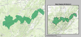
West Virginia's 2nd congressional district stretches from the Ohio River border with Ohio to the Potomac River border with Maryland and the border with Virginia. It includes the capital city of Charleston and the rapidly growing residential communities of West Virginia's Eastern Panhandle and Potomac Highlands regions connected by a narrow strip of nearly unpopulated counties. It has been accurately described as 20 miles wide and 300 miles long.

Southern West Virginia is a culturally and geographically distinct region in the U.S. state of West Virginia. Generally considered the heart of Appalachia, Southern West Virginia is known for its coal mining heritage and Southern affinity. The region is also closely identified with southwestern Virginia and southeastern Kentucky, with close proximity to northwestern North Carolina and East Tennessee. Today, Southern West Virginia continues to grapple with poverty and continuing population loss. Almost the entire region is located in West Virginia's 3rd congressional district, which was represented by Evan Jenkins until he resigned on September 30, 2018 to take a seat as a Justice on the Supreme Court of Appeals of West Virginia.

Samuel Price was Virginia lawyer and politician, who helped to establish the state of West Virginia during the American Civil War and became Lieutenant Governor, and later a United States Senator.
Larry Alan Tucker was an American politician.

John D. Alderson was a lawyer and Democratic politician from West Virginia who served as a United States Representative from West Virginia.

Belva is an unincorporated community and census-designated place in west Nicholas County and north Fayette County, West Virginia, United States; while the CDP only includes the Nicholas County portion, the Fayette County portion is considered part of the community. The town is situated at the bottomland surrounding the convergence of Bells Creek with Twentymile Creek and, subsequently, Twenty Mile Creek with the Gauley River. Belva is also the location of the convergence of two state highways: West Virginia Route 16 and West Virginia Route 39.
Curtin is a nearly abandoned unincorporated community in eastern Nicholas County, West Virginia, United States. The area is situated at the bottomland surrounding the mouth of the Cherry River at its confluence with the Gauley River. Curtin is also the location where West Virginia Route 55 and West Virginia Route 20 cross the Gauley.
Tioga is a census-designated place (CDP) in northeastern Nicholas County, West Virginia, United States. As of the 2010 census, its population was 98. The town is located along a road alternatively called Tioga Road in Nicholas County and Strouds Creek Road in Webster County. The road can be accessed from West Virginia Route 20 in Allingdale and West Virginia Route 55 near Craigsville.
This is a list of the National Register of Historic Places listings in Nicholas County, West Virginia.
Mount Nebo is an unincorporated community in Nicholas County, West Virginia, United States. Mount Nebo is located at the junction of West Virginia Route 41 and West Virginia Route 129 5.5 miles (8.9 km) south of Summersville. Mount Nebo has a post office with ZIP code 26679. Mount Nebo is the home of the Summersville Lake Lighthouse which was established on June 20th, 2013. It is the only working lighthouse in the state of West Virginia. It is listed in the FAA Charts so it is an aeronautical navigational aid. Students from neighboring counties, the Nicholas County Career & Technical School and the Fayette Institute of Technology helped build the 122 steps and the lamp room frame. Two students were hired to help complete the Lighthouse and intern under Master Welders from Amick's Welding. More information on southsideofthelake.com The community was named after Mount Nebo, in West Asia.
Nallen is an unincorporated community in Fayette and Nicholas counties, West Virginia, United States. Nallen is located along West Virginia Route 41 12 miles (19 km) south of Summersville. Nallen has a post office with ZIP code 26680.
Dixie is a census-designated place (CDP) in Fayette and Nicholas counties, West Virginia, United States. Dixie is located on West Virginia Route 16 5.5 miles (8.9 km) north of Gauley Bridge. Dixie has a post office with ZIP code 25059. As of the 2010 census, its population was 291, with 202 residents in Nicholas County and 89 in Fayette County.
Bentree is an unincorporated community in Clay and Nicholas counties, West Virginia, United States. Bentree is located on West Virginia Route 16, 8 miles (13 km) north of Gauley Bridge.
Green Valley is an unincorporated community in Nicholas County, West Virginia, United States. Green Valley is located along West Virginia Route 20 3 miles (4.8 km) north of Quinwood.
Snow Hill is an unincorporated community in Nicholas County, West Virginia, United States. Snow Hill is 10.5 miles (16.9 km) south-southeast of Summersville.
Donald is an unincorporated community in Nicholas County, West Virginia, United States. Donald is located by Richwood Municipal Airport 7.8 miles (12.6 km) east of Summersville.
Coe is an unincorporated community in Nicholas County, West Virginia, United States. Coe is located on County Route 7/6 5.4 miles (8.7 km) east of Craigsville.
Waggy was an unincorporated community on the border of Braxton County and Nicholas County, West Virginia, located just west of the Webster County line on the road from Bays to Erbacon and a logging railroad from Ramp Run. It was also known as Rose Hill.


