
Webster County is a county in the U.S. state of West Virginia. As of the 2020 census, the population was 8,378. Its county seat is Webster Springs. The county was founded in 1860 and named for Daniel Webster.

Ansted is a town in Fayette County in the U.S. state of West Virginia. The population was 1,404 at the 2010 census. It is situated on high bluffs along U.S. Route 60 on a portion of the Midland Trail near Hawks Nest overlooking the New River far below.

Summersville is a city in Nicholas County, West Virginia, United States. The population was 3,459 at the 2020 census. It is the county seat of Nicholas County.
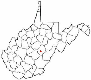
Bolair is a small unincorporated community in Webster County, West Virginia, United States, on West Virginia Route 20. To the east is the smaller town of Jerryville. Both towns are about 75 miles east of the state capital, Charleston. The Gauley River runs through the center of the community.
The Battle of Carnifex Ferry took place on September 10, 1861 in Nicholas County, Virginia, as part of the Operations in Western Virginia Campaign during the American Civil War. The battle resulted in a Union strategic victory that contributed to the eventual Confederate withdrawal from western Virginia, which in turn led to the creation of the State of West Virginia two years later.
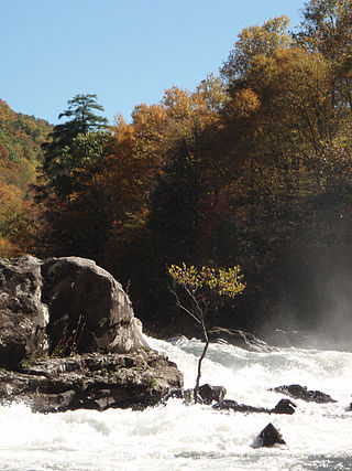
The Gauley River is a 105-mile-long (169 km) river in West Virginia. It merges with the New River to form the Kanawha River, a tributary of the Ohio River. The river features numerous recreational whitewater areas, including those in Gauley River National Recreation Area downstream of the Summersville Dam.

The Williams River is a tributary of the Gauley River, 33 miles (53 km) long, in east-central West Virginia, USA. Via the Gauley, Kanawha and Ohio Rivers, it is part of the watershed of the Mississippi River, draining an area of 132 square miles (342 km²) in a sparsely populated region of the southern Allegheny Mountains and the unglaciated portion of the Allegheny Plateau.
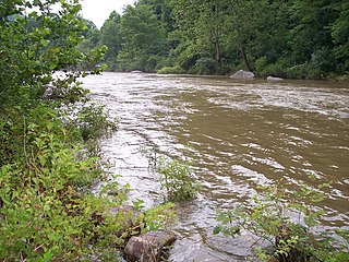
The Cherry River is a tributary of the Gauley River in southeastern West Virginia in the United States. Via the Gauley, Kanawha and Ohio rivers, it is part of the watershed of the Mississippi River. The Cherry River drains mostly rural and forested areas and flows for much of its length through the Monongahela National Forest. Throughout its entire length the Cherry goes over a series of whitewater rapids in a mountainous setting.
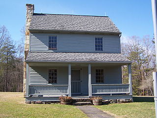
Carnifex Ferry Battlefield State Park is an American Civil War battle site that commemorates the Battle of Carnifex Ferry. It is located on the rim of the Gauley River Canyon near Summersville, a town in Nicholas County, West Virginia. The 156-acre (0.63 km2) park features Patterson House Museum, three views of the Gauley River, hiking trails and picnic facilities. It is one of the oldest state parks in the United States. A Civil War re-enactment takes place on a weekend after Labor Day. As Carnifex Ferry State Park, it was listed on the National Register of Historic Places in 1974.

Summersville Lake is a reservoir located in the US state of West Virginia. The lake is formed by a rock-fill dam on the Gauley River, south of Summersville in Nicholas County. It is the largest lake in West Virginia, with 2,700 acres (1,100 ha) of water and over 60 miles (97 km) of shoreline at the summer pool water level. Its maximum depth is 327 feet.
Swiss is an unincorporated community in western Nicholas County, West Virginia, United States. Its elevation is 735 ft (224 m).
Belva is an unincorporated community and census-designated place in west Nicholas County and north Fayette County, West Virginia, United States; while the CDP only includes the Nicholas County portion, the Fayette County portion is considered part of the community. The town is situated at the bottomland surrounding the convergence of Bells Creek with Twentymile Creek and, subsequently, Twenty Mile Creek with the Gauley River. Belva is also the location of the convergence of two state highways: West Virginia Route 16 and West Virginia Route 39.

The Meadow River is a tributary of the Gauley River, making its headwaters in Greenbrier County and terminating in Nicholas County of West Virginia. It is named for the grassy meadows wetlands which its upper watershed drains, and from which it springs.
Gauley Mills is an unincorporated community in Webster County, West Virginia, United States. Gauley Mills is located on the Gauley River, east of Camden-on-Gauley.
Woodbine is an unincorporated community in Nicholas County, West Virginia, United States. Woodbine is located at the mouth of the Cranberry River at the Gauley River, 3 miles (4.8 km) southeast of Craigsville.
Dixie is a census-designated place (CDP) in Fayette and Nicholas counties, West Virginia, United States. Dixie is located on West Virginia Route 16, 5.5 miles (8.9 km) north of Gauley Bridge. Dixie has a post office with ZIP code 25059. As of the 2010 census, its population was 291, with 202 residents in Nicholas County and 89 in Fayette County.
Bentree is an unincorporated community in Clay and Nicholas counties, West Virginia, United States. Bentree is located on West Virginia Route 16, 8 miles (13 km) north of Gauley Bridge.
Jodie, also known as Imboden, is an unincorporated community in Fayette County, West Virginia, United States. It is located along the Gauley River at the mouth of Rich Creek, 4 miles (6.4 km) northeast of Gauley Bridge. Due to its proximity to the county line, Jodie is part of the Nicholas County ZIP code of 26690; it had its own post office until its closure on July 23, 2005.

Weston and Gauley Bridge Turnpike is a segment of a historic turnpike and hiking trail located at Burnsville, Braxton County, West Virginia. It is a 10 mile long section of trail, approximately 20 feet in width, with an unpaved surface. It is administered by the Army Corps of Engineers. The route was built starting in 1847 to provide access to Sutton for transport of product to grist mills and sawmills, access to the Bulltown sawmills and salt works, and farmland in Lewis, Braxton, and Nicholas counties. During the American Civil War, the turnpike was used in 1861 by Union troops to move to take control of western Virginia. It was also critical in the movement of troops during the Battle of Bulltown on October 13, 1863.
Nicholas County Schools is a school district serving Nicholas County, West Virginia. Its main office is in Summersville, West Virginia


