
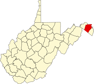
Nicholas County is a county located in the central region of U.S. state of West Virginia. As of the 2020 census, the population was 24,604. Its county seat is Summersville. The county was created in 1818 by the Virginia General Assembly and named for Virginia Governor Wilson Cary Nicholas.
The Battle of Kessler's Cross Lanes, also known as the Battle of Cross Lanes, took place on August 26, 1861 in Nicholas County, Virginia as part of the Western Virginia Campaign during the American Civil War.
The Battle of Carnifex Ferry took place on September 10, 1861 in Nicholas County, Virginia, as part of the Operations in Western Virginia Campaign during the American Civil War. The battle resulted in a Union strategic victory that contributed to the eventual Confederate withdrawal from western Virginia, which in turn led to the creation of the State of West Virginia two years later.

Dinwiddie is an unincorporated community, census-designated place (CDP), and the county seat of Dinwiddie County, Virginia, United States. It was first listed as a CDP in the 2020 census with a population of 619.

Manassas National Battlefield Park is a unit of the National Park Service located in Prince William County, Virginia, north of Manassas that preserves the site of two major American Civil War battles: the First Battle of Bull Run, also called the Battle of First Manassas, and the Second Battle of Bull Run or Battle of Second Manassas. It was also where Confederate General Thomas J. Jackson acquired his nickname "Stonewall". The park was established in 1936 and listed on the National Register of Historic Places on October 15, 1966.

Switchback is an unincorporated community in McDowell County, West Virginia, United States. Switchback had its own high school in operation from 1923 to 1953.

Staunton National Cemetery is a United States National Cemetery located in the Shenandoah Valley, in Staunton, Virginia. Administered by the United States Department of Veterans Affairs, it encompasses just over a single acre, and as of the end of 2005 had 994 interments. It is closed to new interments, and is maintained by the Culpeper National Cemetery.
Bloomfield is an unincorporated community in Loudoun County, Virginia. It is situated at the intersection of Airmont and Bloomfield Roads.

Parkfairfax is a neighborhood in Alexandria, Virginia, United States, located in the northwestern part of the city near the boundary with Arlington County. Nearby thoroughfares are Interstate 395, State Route 402, and West Glebe Road.
Malden — originally called Kanawha Salines — is an unincorporated community in Kanawha County, West Virginia, United States, within the Charleston metro area.
Lockwood is an unincorporated community in western Nicholas County, West Virginia, United States. The town is situated along Otter Creek and West Virginia Route 39.
This is a list of the National Register of Historic Places listings in Berkeley County, West Virginia.
Bartow is a census-designated place (CDP) in Pocahontas County, West Virginia, United States. The population was 111 at the 2010 census.

The Memphis Parkway System is a system of parkways that formed the original outer beltway around Memphis, Tennessee. They consist of South Parkway, East Parkway, and North Parkway. Designed by George Kessler, the Parkway System connects Martin Luther King Jr. Riverside Park with Overton Park. The system was put on the National Register of Historic Places on July 3, 1989.
Woodford is an unincorporated community in Caroline County, in the U.S. state of Virginia. It is located primarily along Route 626 northwest of Bowling Green.
Confederate Cemetery at Lewisburg is a historic cemetery located at Lewisburg, Greenbrier County, West Virginia. The cemetery is the final resting place of 95 unknown Confederate soldiers from the Battles of Lewisburg and Droop Mountain. They are buried in a three-foot-high mound shaped as a Christian cross. The cross measures 80 feet, 5 inches in length, with the "arm" extending 53 feet. There are four commemorative monuments, including one installed by the Federal government in 1956. It is enclosed by a six-foot-high wrought iron fence.
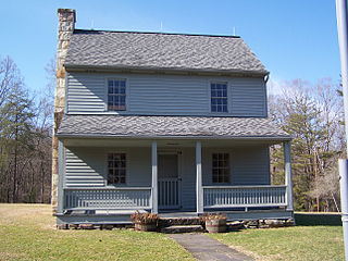
Capt. John Halstead Farm is a historic home and farm located near Kesslers Cross Lanes, Nicholas County, West Virginia. It was built about 1876, and is a two-story side gable with a rear gable two-story wing. It features a full-length, two-story porch on the front of the house and one on the side of the wing in the rear. Also on the property are a contributing gable-roofed tool shed, a small barn, a long narrow chicken coop, an outhouse, and a large barn. It is an example of the local type of residence and subsistence farm.

McDowell is an unincorporated community in Highland County, Virginia, United States. McDowell is 7.2 miles (11.6 km) southeast of Monterey, Virginia on U.S. Route 250. It is in the Bullpasture Valley near the mouth of Crab Run on the Bullpasture River. The community was named after James McDowell, governor of Virginia from 1843 to 1846. McDowell is the location of the May 8, 1862 Battle of McDowell during the American Civil War. The community has a post office with ZIP code 24458 that was established in 1828.
Cross Lanes or Cross Lane may refer to one of these places:
The Rocks, also known as Raven's Rock and Raven Rocks, is a late-18th-century stone residence and 79-acre (32 ha) farm complex near Charles Town, Jefferson County, in the U.S. state of West Virginia. The Rocks is a historic district consisting of four contributing structures. The primary structure is a 2-and-a-half-story stone residence known as The Rocks, which was built around 1790, in the Georgian architectural style.


