
Nicholas County is a county located in the central region of U.S. state of West Virginia. As of the 2010 census, the population was 26,233. Its county seat is Summersville. The county was created in 1818 by the Virginia General Assembly and named for Virginia Governor Wilson Cary Nicholas.

Palestine is an unincorporated community in Wirt County, West Virginia, United States. It is located at the confluence of the Little Kanawha River and Reedy Creek, at 39°01′48″N81°24′24″W, at an elevation of 682 feet. Its ZIP code is 26160. The community was named after Palestine.

Belva Ann Bennett Lockwood was an American attorney, politician, educator, and author. She was active in working for women's rights, including women's suffrage. Lockwood overcame many social and personal obstacles related to gender restrictions. After college, she became a teacher and principal, working to equalize pay for women in education. She supported the movement for world peace, and was a proponent of the Temperance movement.
Darkesville is an unincorporated community in Berkeley County, West Virginia, United States. Established in 1791, Darkesville has been nationally recognized as a historic district.

Algoma is an unincorporated community in McDowell County, West Virginia, United States. Algoma is located adjacent to the town of Northfork. Its post office was established in 1891 and discontinued in 1988. Algoma most likely was derived from the Algonquin language.

Elkhorn is an unincorporated community in McDowell County, West Virginia, United States. Elkhorn lies on U.S. Route 52 and takes its name from the creek that flows through the community.

French Creek is an unincorporated community in Upshur County, West Virginia, United States.
Malden — originally called Kanawha Salines — is an unincorporated community in Kanawha County, West Virginia, United States, within the Charleston metro area.
Kessler's Cross Lanes is an unincorporated community along Route 129 in Nicholas County, West Virginia, United States. Just south of Kessler's Cross Lanes is Carnifex Ferry Battlefield State Park, which is a park of historical interest; a Civil War battle was fought at the site in 1863.
Hacker Valley is an unincorporated community in northern Webster County, West Virginia, USA, along the Left Fork of the Holly River. Its ZIP Code is 26222.
Swiss is an unincorporated community in western Nicholas County, West Virginia, United States. Its elevation is 735 ft (224 m).
Belva is an unincorporated community and census-designated place in west Nicholas County and north Fayette County, West Virginia, United States; while the CDP only includes the Nicholas County portion, the Fayette County portion is considered part of the community. The town is situated at the bottomland surrounding the convergence of Bells Creek with Twentymile Creek and, subsequently, Twenty Mile Creek with the Gauley River. Belva is also the location of the convergence of two state highways: West Virginia Route 16 and West Virginia Route 39.
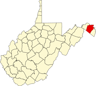
This is a list of the National Register of Historic Places listings in Berkeley County, West Virginia.
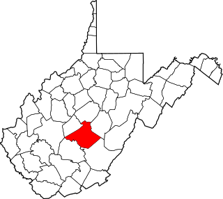
This is a list of the National Register of Historic Places listings in Nicholas County, West Virginia.
Drennen is an unincorporated community in Nicholas County, West Virginia, United States. Drennen is located on West Virginia Route 39, 8 miles (13 km) west of Summersville. Drennen has a post office with ZIP code 26667.
Landisburg is an unincorporated community in Fayette County, West Virginia, United States. Landisburg is located along West Virginia Route 41, 11 miles (18 km) east of Oak Hill.
Mount Clare is an unincorporated community in Harrison County, West Virginia, United States. Mount Clare is 4.5 miles (7.2 km) south of Clarksburg. Mount Clare has a post office with ZIP code 26408.
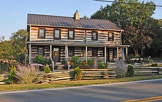
Lockwood Historic District is a national historic district located at Lockwood, Nicholas County, West Virginia, United States. The district includes 26 contributing buildings and 1 contributing site. The district encompasses the community of Lockwood. All the buildings are of frame or log construction. Notable buildings include the Fairview Baptist Church (1916), Summers Residence (1990), Gay Grose House, and Hill House. Also included are the Summers Cemetery and the Morris grave site and monument.
Cranesville is an unincorporated community in Preston County, West Virginia, United States. Cranesville is located along County Route 47 7.9 miles (12.7 km) north-northeast of Terra Alta.
Coe is an unincorporated community in Nicholas County, West Virginia, United States. Coe is located on County Route 7/6, 5.4 miles (8.7 km) east of Craigsville.


