Oldman River

Last updated

Oldman River
Oldman river-Alberta.JPG
Oldman River seen from Veterans Memorial Highway
South Saskatchewan basin map.png
The South Saskatchewan River drainage basin
Canada Alberta relief location map - transverse mercator proj.svg
Red pog.svg
The mouth in Alberta
Canada relief map 2.svg
Red pog.svg
Oldman River (Canada)
Location
Country Canada
Province Alberta
Physical characteristics
Source 
  location Canadian Rockies
  coordinates 50°06′50″N114°43′14″W / 50.11389°N 114.72056°W / 50.11389; -114.72056
  elevation2,100 m (6,900 ft)
Mouth  
  location
South Saskatchewan River
  coordinates
49°55′45″N111°41′27.4″W / 49.92917°N 111.690944°W / 49.92917; -111.690944 Coordinates: 49°55′45″N111°41′27.4″W / 49.92917°N 111.690944°W / 49.92917; -111.690944
  elevation
701 m (2,300 ft)
Length363 km (226 mi)
Basin size26,700 km2 (10,300 sq mi) [1]
Discharge 
  average95 m3/s (3,400 cu ft/s). [1]

The Oldman River is a river in southern Alberta, Canada. It flows roughly west to east from the Rocky Mountains, through the communities of Fort Macleod, Lethbridge, and on to Grassy Lake, where it joins the Bow River to form the South Saskatchewan River, which eventually drains into the Hudson Bay.

Contents

Oldman River has a total length of 362 kilometres (225 mi) and a drainage area of 26,700 km2 (10,300 sq mi). [1]

History

The Oldman River was, at one time, known as the Belly River. [2] The Belly River is now a separate river that is a tributary of the Oldman.

In 1991, the Alberta government finished construction of the Oldman River Dam. The Piikani renegade, led by Milton Born With A Tooth, had attempted to divert the Oldman River away from the Lethbridge Northern Irrigation District canal intake, leading to an armed standoff. [3] The dam was constructed where the Oldman, Crowsnest, and Castle river systems converge.

2013 floods

On June 21, 2013, during the 2013 Alberta floods Alberta experienced heavy rainfall that triggered catastrophic flooding throughout much of the southern half of the province along the Bow, Elbow, Highwood and Oldman rivers and tributaries. A dozen municipalities in Southern Alberta declared local states of emergency on June 21 as water levels rose and numerous communities were placed under evacuation orders. [4]

Tributaries

Map symbol-pin.svg
Alberta rivers.png
Oldman River in Alberta

From headwaters to mouth, Oldman River receives:

Nature

Oldman River originates in the Beehive Natural Area, [5] an area of alpine tundra and old-growth spruce and fir forests. Downstream it flows through Bob Creek Wildland Provincial Park [6] and Black Creek Heritage Rangeland. [7] Oldman Dam and Oldman River are other Provincial Recreation Areas established along the river.

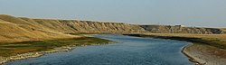
The river and some of its tributaries have formed coulees in Southern Alberta, and the strata revealed by these formations guide local prospectors to ammolite deposits.

Fish

The Oldman River contains fish species such as rainbow trout, cutthroat trout, bull trout, brown trout, hybrid trout species ("cutbow" rainbow and cutthroat cross), mountain whitefish, pike, walleye, lake sturgeon, catostomidae, goldeye, and minnows. [8]

See also

Related Research Articles

<span class="mw-page-title-main">South Saskatchewan River</span> River in Western Canada

The South Saskatchewan River is a major river in the Canadian provinces of Alberta and Saskatchewan. The river begins at the confluence of the Bow and Oldman Rivers in southern Alberta and ends at the Saskatchewan River Forks in central Saskatchewan. The Saskatchewan River Forks is the confluence of the South and North Saskatchewan Rivers and is the beginning of the Saskatchewan River.

<span class="mw-page-title-main">Crowsnest Highway</span> Canadian cross-provincial highway (est. 1932)

The Crowsnest Highway is an east-west highway in British Columbia and Alberta, Canada. It stretches 1,161 km (721 mi) across the southern portions of both provinces, from Hope, British Columbia to Medicine Hat, Alberta, providing the shortest highway connection between the Lower Mainland and southeast Alberta through the Canadian Rockies. Mostly two-lane, the highway was officially designated in 1932, mainly following a mid-19th-century gold rush trail originally traced out by an engineer named Edgar Dewdney. It takes its name from the Crowsnest Pass, the location at which the highway crosses the Continental Divide between British Columbia and Alberta.

<span class="mw-page-title-main">St. Mary River (Alberta–Montana)</span> River in Montana, United States and Canada

The Saint Mary River is a cross-border tributary of the Oldman River, itself a tributary of the South Saskatchewan River. The Saint Mary together with the Belly River and Waterton River drains a small portion of Montana, in the United States, to the Hudson Bay watershed in Canada.

<span class="mw-page-title-main">Battle Creek (Milk River tributary)</span> River in central North America

Battle Creek is a river that begins in the south-eastern region of the Canadian province of Alberta, near the border with Saskatchewan, in the Cypress Hills Interprovincial Park. From Alberta, Battle Creek flows east and across the border into Saskatchewan. It flows south out of Saskatchewan across the Canada–United States border into Montana, where it joins the Milk River in Blaine County, Montana.

<span class="mw-page-title-main">Slough Creek (Wyoming)</span> River in Montana and Wyoming, United States

Slough Creek is a tributary of the Lamar River, approximately 25 mi (40 km) long, in Montana and Wyoming in the United States.

<span class="mw-page-title-main">Bow River</span> River in Alberta, Canada

The Bow River is a river in Alberta, Canada. It begins within the Canadian Rocky Mountains and winds through the Alberta foothills onto the prairies, where it meets the Oldman River, the two then forming the South Saskatchewan River. These waters ultimately flow through the Nelson River into Hudson Bay. The Bow River runs through the city of Calgary, taking in the Elbow River at the historic site of Fort Calgary near downtown. The Bow River pathway, developed along the river's banks, is considered a part of Calgary's self-image.

<span class="mw-page-title-main">Elbow River</span> River in Alberta, Canada

The Elbow River is a river in southern Alberta, Canada. It flows from the Canadian Rockies to the city of Calgary, where it merges into the Bow River.

<span class="mw-page-title-main">Red Deer River</span> River in Alberta and Saskatchewan, Canada

The Red Deer River is a river in Alberta and a small portion of Saskatchewan, Canada. It is a major tributary of the South Saskatchewan River and is part of the larger Saskatchewan-Nelson system that empties into Hudson Bay.

<span class="mw-page-title-main">Alberta Highway 3</span> Highway in Alberta, Canada

Alberta Provincial Highway No. 3, commonly referred to as Highway 3 and officially named the Crowsnest Highway, is a 324-kilometre (201 mi) highway that traverses southern Alberta, Canada, running from the Crowsnest Pass through Lethbridge to the Trans-Canada Highway in Medicine Hat. Together with British Columbia Highway 3 which begins in Hope, it forms an interprovincial route that serves as an alternate to the Trans-Canada from the Lower Mainland to the Canadian Prairies.

<span class="mw-page-title-main">Crowsnest River</span>

The Crowsnest River is a tributary to the Oldman River in southwestern Alberta, Canada.

Kikomun Creek Provincial Park is a provincial park in British Columbia, Canada.

Strawberry Reservoir is a large reservoir in the U.S. state of Utah. It is Utah's most popular fishery, receiving over 1.5 million angling hours annually and is part of the Blue Ribbon Fisheries program. Game fish in the reservoir include sterilized rainbow trout, bear lake cutthroat trout, kokanee salmon and crayfish. It is located 23 miles (37 km) southeast of Heber, Utah on U.S. Route 40. The reservoir is situated in Strawberry Valley. This valley is normally part of the Colorado River drainage. The dam was constructed to divert water into Utah Valley.

<span class="mw-page-title-main">Highwood River</span> River in Alberta, Canada

The Highwood River is a tributary of the Bow River in southwestern Alberta, Canada.

<span class="mw-page-title-main">Westslope cutthroat trout</span> Subspecies of fish

The westslope cutthroat trout, also known as the black-spotted trout, common cutthroat trout and red-throated trout is a subspecies of the cutthroat trout and is a freshwater fish in the salmon family of order Salmoniformes. The cutthroat is the Montana state fish. This subspecies is a species of concern in its Montana and British Columbia ranges and is considered threatened in its native range in Alberta.

<span class="mw-page-title-main">Southern Alberta</span> Region of Alberta, Canada (est. 1905)

Southern Alberta is a region located in the Canadian province of Alberta. In 2016, the region's population was approximately 291,112. The primary cities are Lethbridge and Medicine Hat. The region is known mostly for agricultural production, but other sectors, such as alternative energy, film production and tourism, are emerging.

Alberta Provincial Highway No. 3A, commonly referred to as Highway 3A, is the designation of four alternate routes of Highway 3 in southern Alberta, Canada. All four segments are former alignments of Highway 3, also known as the Crowsnest Highway.

<span class="mw-page-title-main">Red Coat Trail</span> Highway in Alberta, Saskatchewan, Manitoba

The Red Coat Trail is a 1,300-kilometre (810 mi) route that approximates the path taken in 1874 by the North-West Mounted Police in their March West from Fort Dufferin to Fort Whoop-Up.

<span class="mw-page-title-main">Belly River</span> River in Canada, United States

Belly River is a river in northwest Montana, United States and southern Alberta, Canada. It is a tributary of the Oldman River, itself a tributary of the South Saskatchewan River.

<span class="mw-page-title-main">Bluerock Wildland Provincial Park</span> Protected area in southwestern Alberta, Canada

Bluerock Wildland Provincial Park is a wildland provincial park located in Kananaskis Improvement District, Alberta, Canada. It was established on 24 July 2001 and has an area of 12,719.59 hectares. The park was named for the Bluerock Creek that flows through and forms part of the western boundary of the park and Bluerock Mountain which is the creek's source. The park is included in the South Saskatchewan Region land use framework and administered by the South Saskatchewan Regional Plan. Sheep River Provincial Park and Bluerock Wildland Provincial Park are managed under the same Management Plan.

Bob Creek Wildland Provincial Park is a wildland provincial park located in the Municipal District of Ranchland, in southern Alberta, Canada. It was established on 12 May 1999, modified slightly on 24 June 2003, and is 20,777.69 hectares in area. The park is included in the South Saskatchewan Region Land Use Framework and administered by the South Saskatchewan Regional Plan. Because they are so intertwined, Bob Creek Wildland and Black Creek Heritage Rangeland are managed through the same Management Plan. The park gets its name from the Bob Creek that runs through the center of the park and drains the surrounding hills.

References

  1. 1 2 3 Atlas of Canada. "Rivers in Canada" . Retrieved January 13, 2007.
  2. "McCord Museum - Keys to History" . Retrieved September 11, 2020.
  3. University of Lethbridge. "Oldman River Dam". Archived from the original on September 24, 2013. Retrieved November 10, 2006.
  4. Kaufmann, Bill (June 21, 2013). "Thousands flee rising waters from Red Deer to Crowsnest". Calgary Sun. p. 3.
  5. Alberta Community Development. "Beehive Natural Area". Archived from the original on August 13, 2004. Retrieved November 12, 2006.
  6. Alberta Community Development. "Bob Creek Wildland Park". Archived from the original on March 10, 2007. Retrieved November 12, 2006.
  7. Alberta Community Development. "Black Creek Heritage Rangeland". Archived from the original on August 13, 2004. Retrieved November 12, 2007.
  8. "AlbertaFishingGuide.com: The Dependable Online Resource For Fishing In Alberta". AlbertaFishingGuide.com. Retrieved February 3, 2020.