The South Saskatchewan River is a major river in the Canadian provinces of Alberta and Saskatchewan. The river begins at the confluence of the Bow and Oldman Rivers in southern Alberta and ends at the Saskatchewan River Forks in central Saskatchewan. The Saskatchewan River Forks is the confluence of the South and North Saskatchewan Rivers and is the beginning of the Saskatchewan River.

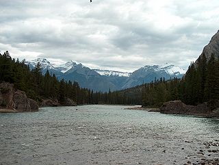
The Bow River is a river in Alberta, Canada. It begins within the Canadian Rocky Mountains and winds through the Alberta foothills onto the prairies, where it meets the Oldman River, the two then forming the South Saskatchewan River. These waters ultimately flow through the Nelson River into Hudson Bay. The Bow River runs through the city of Calgary, taking in the Elbow River at the historic site of Fort Calgary near downtown. The Bow River pathway, developed along the river's banks, is considered a part of Calgary's self-image.

The Eildon Dam is a rock and earth-fill embankment dam with a controlled spillway, located on the Goulburn River between the regional towns of Mansfield and Eildon within Lake Eildon National Park, in the Alpine region of Victoria, Australia. The dam's purpose is for the supply of potable water, irrigation, and the generation of hydroelectricity. The impounded reservoir is called Lake Eildon.The first cut of ground was done by Mr Bain and Mr MacLean from Scotland.

The Peace River is a 1,923-kilometre-long (1,195 mi) river in Canada that originates in the Rocky Mountains of northern British Columbia and flows to the northeast through northern Alberta. The Peace River joins the Athabasca River in the Peace-Athabasca Delta to form the Slave River, a tributary of the Mackenzie River. The Finlay River, the main headwater of the Peace River, is regarded as the ultimate source of the Mackenzie River. The combined Finlay–Peace–Slave–Mackenzie river system is the 13th longest river system in the world.
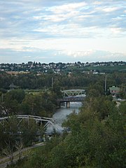
The Elbow River is a river in southern Alberta, Canada. It flows from the Canadian Rockies to the city of Calgary, where it merges into the Bow River.

The Colorado–Big Thompson Project is a federal water diversion project in Colorado designed to collect West Slope mountain water from the headwaters of the Colorado River and divert it to Colorado's Front Range and plains. In Colorado, approximately 80% of the state's precipitation falls on the West Slope, in the Rocky Mountains, while around 80% of the state's growing population lives along the eastern slope, between the cities of Fort Collins and Pueblo.

The Blowering Dam is a major ungated rock fill with clay core embankment dam with concrete chute spillway impounding a reservoir under the same name. It is located on the Tumut River upstream of Tumut in the Snowy Mountains region of New South Wales, Australia. Purposes for the dam include flood mitigation, hydro-power, irrigation, water supply and conservation. The dam is part of the Snowy Mountains Scheme, a vast hydroelectricity and irrigation complex constructed in south-east Australia between 1949 and 1974 and now run by Snowy Hydro.
The Tumut Hydroelectric Power Stations is a series of three hydroelectric power stations on the Tumut River in New South Wales, Australia, that are part of the Snowy Mountains Scheme.

The North Saskatchewan River is a glacier-fed river that flows from the Canadian Rockies continental divide east to central Saskatchewan, where it joins with the South Saskatchewan River to make up the Saskatchewan River. Its water flows eventually into the Hudson Bay.

The Rubicon Hydroelectric Scheme is a small run-of-the-river hydroelectric scheme located on the Rubicon and Royston Rivers, north east of Melbourne, 40 km (25 mi) south-west of Alexandra, Victoria, Australia. The scheme commenced in 1922, and was the first state-owned hydroelectric scheme to generate electricity in mainland Australia, and among the first in the world to be remotely controlled. For the first ten years of its operation it supplied on average 16.9% of electricity generated by the State Electricity Commission of Victoria. It is now owned and operated by AGL Energy and contributes approximately 0.02% of Victoria's energy supply.
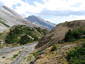
The Spray River is a tributary of the Bow River in western Alberta, Canada.

Bighorn Dam is an embankment dam in Clearwater County in west-central Alberta, Canada. It was built by Calgary Power in 1972, and led to the creation of Lake Abraham, Alberta's largest reservoir. The dam and associated hydroelectric plant are managed by TransAlta.
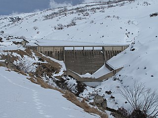
Tumut Pond Dam is a major gated concrete arch dam across the upper reaches of the Tumut River in the Snowy Mountains of New South Wales, Australia. The dam's main purpose is for the generation of hydro-power and is one of the sixteen major dams that comprise the Snowy Mountains Scheme, a vast hydroelectricity and irrigation complex constructed in south-east Australia between 1949 and 1974 and now run by Snowy Hydro.

Brazeau Reservoir is a large man-made reservoir in Alberta, Canada. It is in Brazeau County of central Alberta, 55 kilometres (34 mi) southwest of Drayton Valley. It was developed along the Brazeau River, at the confluence with Elk River, in the hydrographic basin of the North Saskatchewan River.

The Entracque Power Plant, also known as The Upper Gesso Plant, is a pumped-storage hydroelectric power station located in Valle Gesso just south of Entracque, Italy. The power station contains pump-generators for two co-located but hydraulically separated power schemes; the Chiotas-Piastra Plant and Rovina-Piastra Plant. Both plants use separate upper reservoirs but use Lago della Piastra as their common lower reservoir. To produce power, water is released from the upper reservoirs to the power station located at the lower reservoir. The pump-generators re-fill the reservoirs and the process repeats as needed. The Chiotas' upper reservoir, Lago del Chiotas, is located much higher in the valley and larger than Rovina's Lago della Rovina which affords it the ability to produce more electricity. The installed capacity of Chiotas is 1,184 megawatts (1,588,000 hp) with a hydraulic head of 1,048 m (3,438 ft) while Rovina has an installed capacity of 133.67 megawatts (179,250 hp) and a head of 598 metres (1,962 ft). Construction on the plant began in 1962 and operations started in 1982. It is owned and operated by Enel.

The Big Creek Hydroelectric Project is an extensive hydroelectric power scheme on the upper San Joaquin River system, in the Sierra Nevada of central California. The project is owned and operated by Southern California Edison (SCE). The use and reuse of the waters of the San Joaquin River, its South Fork, and the namesake of the project, Big Creek – over a vertical drop of 6,200 ft (1,900 m) – have over the years inspired a nickname, "The Hardest Working Water in the World".
Tumut Two Dam or Tumut Two is a major ungated concrete gravity dam across the upper reaches of the Tumut River in the Snowy Mountains of New South Wales, Australia. The dam's main purpose is for the generation of hydro-power and is one of the sixteen major dams that comprise the Snowy Mountains Scheme, a vast hydroelectricity and irrigation complex constructed in south-east Australia between 1949 and 1974 and now run by Snowy Hydro.
Guthega Dam is concrete gravity dam with an uncontrolled spillway across the Snowy River in the Snowy Mountains of New South Wales, Australia. The dam's main purpose is for the storage of water used in the generation of hydro-power. It is the first to be completed of the sixteen major dams of the Snowy Mountains Scheme, a vast hydroelectricity and irrigation complex constructed in south-east Australia between 1949 and 1974 and now run by Snowy Hydro.

The Yuba–Bear Hydroelectric Project is a complex hydroelectric scheme in the northern Sierra Nevada in California, tapping the upper Yuba River and Bear River drainage basins. The project area encompasses approximately 400 square miles (1,000 km2) in Nevada, Placer, and Sierra Counties. Owned by the Nevada Irrigation District, it consists of 16 storage dams plus numerous diversion and regulating dams, and four generating stations producing 425 million kilowatt hours of electricity each year. The Yuba–Bear Hydroelectric Project consists of the Bowman development, Dutch Flat No. 2 development, Chicago Park development, and Rollins development.

The Upper North Fork Feather River Project is a hydroelectric scheme in the Sierra Nevada of California, within Lassen and Plumas Counties. The project consists of three dams, five power plants, and multiple conduits and tunnels in the headwaters of the North Fork Feather River, a major tributary of the Feather—Sacramento River systems. The total installed capacity is 362.3 megawatts (MW), producing an annual average of 1,171.9 gigawatt hours (GWh). The project is also contracted for the delivery of irrigation water between March 31 and October 31 of each year. The project is owned and operated by Pacific Gas and Electric Company.