This article needs additional citations for verification .(February 2008) |

The Crowsnest River is a tributary to the Oldman River in southwestern Alberta, Canada.
This article needs additional citations for verification .(February 2008) |
The Crowsnest River is a tributary to the Oldman River in southwestern Alberta, Canada.
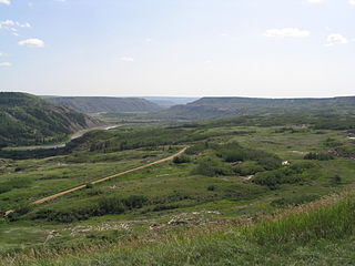
From its source in Crowsnest Lake at an elevation of about 1,357 metres (4,452 ft) in the Canadian Rockies, Crowsnest River meanders eastward through the Municipality of Crowsnest Pass and Frank Slide. It passes into the foothills near Burmis and reaches the western margin of the Alberta plains near Lundbreck. It then joins the Oldman River Reservoir at an elevation of about 1,110 metres (3,640 ft). [1]
The Crowsnest River is highly productive with a substantial insect population fueling a world-class sport fishery for rainbow, westslope cutthroat, bull, hybrid trout ("cutbow" cutthroat and rainbow trout crosses), brown trout (below Lundbreck Falls), mountain whitefish, and various species of suckers.

The South Saskatchewan River is a major river in the Canadian provinces of Alberta and Saskatchewan. The river begins at the confluence of the Bow and Oldman Rivers in southern Alberta and ends at the Saskatchewan River Forks in central Saskatchewan. The Saskatchewan River Forks is the confluence of the South and North Saskatchewan Rivers and is the beginning of the Saskatchewan River.

The Crowsnest Highway is an east-west highway in British Columbia and Alberta, Canada. It stretches 1,161 km (721 mi) across the southern portions of both provinces, from Hope, British Columbia to Medicine Hat, Alberta, providing the shortest highway connection between the Lower Mainland and southeast Alberta through the Canadian Rockies. Mostly two-lane, the highway was officially designated in 1932, mainly following a mid-19th-century gold rush trail originally traced out by an engineer named Edgar Dewdney. It takes its name from the Crowsnest Pass, the location at which the highway crosses the Continental Divide between British Columbia and Alberta.

Crowsnest Pass is a low mountain pass across the Continental Divide of the Canadian Rockies on the Alberta–British Columbia border.

The Oldman River is a river in southern Alberta, Canada. It flows roughly west to east from the Rocky Mountains, through the communities of Fort Macleod, Lethbridge, and on to Grassy Lake, where it joins the Bow River to form the South Saskatchewan River, which eventually drains into the Hudson Bay.

The Red Deer River is a river in Alberta and a small portion of Saskatchewan, Canada. It is a major tributary of the South Saskatchewan River and is part of the larger Saskatchewan / Nelson system that empties into Hudson Bay.

Alberta Provincial Highway No. 3, commonly referred to as Highway 3 and officially named the Crowsnest Highway, is a 324-kilometre (201 mi) highway that traverses southern Alberta, Canada, running from the Crowsnest Pass through Lethbridge to the Trans-Canada Highway in Medicine Hat. Together with British Columbia Highway 3 which begins in Hope, it forms an interprovincial route that serves as an alternate to the Trans-Canada from the Lower Mainland to the Canadian Prairies.
Woolford Provincial Park is a provincial park in Alberta, Canada, located 17.5 km (10.9 mi) east of Cardston, west of Highway 503. This provincial park is situated along St. Mary River at an elevation of 1,130 m (3,710 ft) and has a surface of 0.4 km2 (0.15 sq mi). It lies to the northeast from Waterton Lakes National Park.
Dry Island Buffalo Jump Provincial Park is a provincial park in Central Alberta, Canada, located about 103 km (64 mi) southeast of Red Deer and 16 km (9.9 mi) east of Trochu. The park is situated along the Red Deer River and features badlands topography. Its name derives from the large plateau in the middle of the park, 200 m (660 ft) above the Red Deer River, which has never been developed by humans and retains virgin prairie grasses.
The Harrison River is a short but large tributary of the Fraser River, entering it near the community of Chehalis, British Columbia, Canada. The Harrison drains Harrison Lake and is the de facto continuation of the Lillooet River, which feeds the lake.

Lockhart Beach Provincial Park is a provincial park Located 40 km north of Creston, British Columbia, Canada, on BC Highway 3A. "This park and the adjacent Lockhart Creek Provincial Park extend 3 hectares, from the sunny shores of Kootenay Lake to the headwaters of Lockhart Creek. "This small park provides the only easy access to public camping along the south arm of Kootenay Lake. An 18-site campground and day-use area are located near a sand and fine gravel beach."
Hollebeke is a Flemish village in the Belgian province of West Flanders, now part of Ypres city.

The North Saskatchewan River is a glacier-fed river that flows from the Canadian Rockies continental divide east to central Saskatchewan, where it joins with the South Saskatchewan River to make up the Saskatchewan River. Its water flows eventually into the Hudson Bay.

The westslope cutthroat trout, also known as the black-spotted trout, common cutthroat trout and red-throated trout is a subspecies of the cutthroat trout and is a freshwater fish in the salmon family of order Salmoniformes. The cutthroat is the Montana state fish. This subspecies is a species of concern in its Montana and British Columbia ranges and is considered threatened in its native range in Alberta.
Alberta Provincial Highway No. 3A, commonly referred to as Highway 3A, is the designation of four alternate routes of Highway 3 in southern Alberta, Canada. All four segments are former alignments of Highway 3, also known as the Crowsnest Highway.

Crowsnest Lake is a lake in southwestern Alberta, Canada. It lies near the summit of the Crowsnest Pass in the southern Canadian Rockies and gives rise to the Crowsnest River.
The Little Bow River is a tributary of the Oldman River in southern Alberta, Canada. It is about 190 kilometres (120 mi) long. From its headwaters near High River, it flows south, then turns east and flows into Travers Reservoir. Afterwards, it flows southeast into the Oldman River near Picture Butte. The Little Bow is related to the Bow River as they both ultimately feed the South Saskatchewan River.
Pincher Creek-Crowsnest was a provincial electoral district in Alberta, Canada, mandated to return a single member to the Legislative Assembly of Alberta from 1940 to 1993.

Lundbreck Falls is a waterfall of the Crowsnest River located in southwestern Alberta, Canada near the hamlet of Lundbreck.

Bluerock Wildland Provincial Park is a wildland provincial park located in Kananaskis Improvement District, Alberta, Canada. It was established on 24 July 2001 and has an area of 12,719.59 hectares. The park was named for the Bluerock Creek that flows through and forms part of the western boundary of the park and Bluerock Mountain which is the creek's source. The park is included in the South Saskatchewan Region land use framework and administered by the South Saskatchewan Regional Plan. Sheep River Provincial Park and Bluerock Wildland Provincial Park are managed under the same Management Plan.
Bob Creek Wildland Provincial Park is a wildland provincial park located in the Municipal District of Ranchland, in southern Alberta, Canada. It was established on 12 May 1999, modified slightly on 24 June 2003, and is 20,777.69 hectares in area. The park is included in the South Saskatchewan Region Land Use Framework and administered by the South Saskatchewan Regional Plan. Because they are so intertwined, Bob Creek Wildland and Black Creek Heritage Rangeland are managed through the same Management Plan. The park gets its name from the Bob Creek that runs through the center of the park and drains the surrounding hills.
| Rivers |  | |
|---|---|---|
| Waterfalls | ||
| Lakes | ||
| Reservoirs | ||
| Glaciers | ||
| Other | ||
49°35′59″N114°02′57″W / 49.59972°N 114.04917°W
| International | |
|---|---|
| National | |
| | This Southern Alberta location article is a stub. You can help Wikipedia by expanding it. |