Abrasion (geology)

Last updated
Glacially abraded rocks in western Norway near Jostedalsbreen gntration Glacial-abrasion-ss-2006.jpg
Glacially abraded rocks in western Norway near Jostedalsbreen gntration

Abrasion is a process of erosion that occurs when material being transported wears away at a surface over time, commonly happens in ice and glaciers. The primary process of abrasion is physical weathering. Its the process of friction caused by scuffing, scratching, wearing down, marring, and rubbing away of materials. The intensity of abrasion depends on the hardness, concentration, velocity and mass of the moving particles. Abrasion generally occurs in four ways: [1] [2] glaciation slowly grinds rocks picked up by ice against rock surfaces; [3] solid objects transported in river channels make abrasive surface contact with the bed and walls; objects transported in waves breaking on coastlines; and by wind transporting sand or small stones against surface rocks. Abrasion is the natural scratching of bedrock by a continuous movement of snow or glacier downhill. This is caused by a force, friction, vibration, or internal deformation of the ice, and by sliding over the rocks and sediments at the base (that also causes an avalanche) that causes the glacier to move.

Contents

Abrasion, under its strictest definition, is commonly confused with attrition and sometimes hydraulic action however, the latter less commonly so. Both abrasion and attrition refers to the wearing down of an object. Abrasion occurs as a result of two surfaces rubbing against each other, resulting in the wearing down of one or both of the surfaces. However, attrition refers to the breaking off of particles (erosion) which occurs as a result of objects hitting against each other. Abrasion leads to surface-level destruction over a period of time, whereas attrition results in more change at a faster rate. Today, the geomorphology community uses the term "abrasion" in a looser way, often interchangeably with the term "wear". [4]

In channel transport

Abrasion in a stream or river channel occurs when the sediment carried by a river scours the bed and banks, contributing significantly to erosion. In addition to chemical and physical weathering of hydraulic action, freeze-thaw cycles, and more, there is a suite of processes which have long been considered to contribute significantly to bedrock channel erosion include plucking, abrasion (due to both bedload and suspended load), solution, and cavitation. [5] [6] In terms of a glacier, it is a similar principal; the moving of rocks over a surface wears it away with friction, digging a channel that, when the glacier moves away, is called a U-shaped valley.

Bedload transport consists of mostly larger clasts, which cannot be picked up by the velocity of the streamflow, rolling, sliding, and/or saltating (bouncing) downstream along the bed. Suspended load typically refers to smaller particles, such as silt, clay, and finer grain sands uplifted by processes of sediment transport. Grains of various sizes and composition are transported differently in terms of the threshold flow velocities required to dislodge and deposit them, as is modeled in the Hjulström curve. These grains polish and scour the bedrock and banks when they make abrasive contact.[ citation needed ]

In coastal erosion

Abrasion platform in the Parque Natural del Estrecho, at the Strait of Gibraltar coast in Andalusia, Spain Plataforma de abrasion (6111819085).jpg
Abrasion platform in the Parque Natural del Estrecho, at the Strait of Gibraltar coast in Andalusia, Spain

Coastal abrasion occurs as breaking ocean waves containing a sand and larger fragments erode the shoreline or headland. The hydraulic action of waves contributes heavily. This removes material, resulting in undercutting and possible collapse of unsupported overhanging cliffs. This erosion can threaten structure or infrastructure on coastlines, and the impact will very likely increase as global warming increases sea level rise. [7] Seawalls are sometimes built-in defense, but in many locations, conventional coastal engineering solutions such as sea walls are increasingly challenged and their maintenance may become unsustainable due to changes in climate conditions, sea-level rise, land subsidence, and sediment supply. [8]

Abrasion platforms are shore platforms where wave action abrasion is a prominent process. If it is currently being fashioned, it will be exposed only at low tide, but there is a possibility that the wave-cut platform will be hidden sporadically by a mantle of beach shingle (the abrading agent). If the platform is permanently exposed above the high-water mark, it is probably a raised beach platform, which is not considered a product of abrasion but may be undercut by abrasion as sea level rises.[ citation needed ]

From glaciation

Glacial abrasion is the surface wear achieved by individual clasts, or rocks of various sizes, contained within ice or by subglacial sediment as the glacier slides over bedrock. [9] Abrasion can crush smaller grains or particles and remove grains or multigrain fragments, but the removal of larger fragments is classified as plucking (or quarrying), the other major erosion source from glaciers. Plucking creates the debris at the base or sides of the glacier that causes abrasion. While plucking has generally been thought of as a greater force of geomorphological change, there is evidence that in softer rocks with wide joint spacing that abrasion can be just as efficient. [9] A smooth, polished surface is left behind by glacial abrasion, sometimes with glacial striations, which provide information about the mechanics of abrasion under temperate glaciers. [10]

From wind

Much consideration has been given to the role of wind as an agent of geomorphological change on Earth and other planets (Greely & Iversen 1987). Aeolian processes involve wind eroding materials, such as exposed rock, and moving particles through the air to contact other materials and deposit them elsewhere. These forces are notably similar to models in fluvial environments. Aeolian processes demonstrate their most notable consequences in arid regions of sparse and abundant unconsolidated sediments, such as sand. There is now evidence that bedrock canyons, landforms traditionally thought to evolve only from the fluvial forces of flowing water, may indeed be extended by the aeolian forces of wind, perhaps even amplifying bedrock canyon incision rates by an order of magnitude above fluvial abrasion rates. [11] Redistribution of materials by wind occurs at multiple geographic scales and can have important consequences for regional ecology and landscape evolution. [12]

Related Research Articles

<span class="mw-page-title-main">Erosion</span> Natural processes that remove soil and rock

Erosion is the action of surface processes that removes soil, rock, or dissolved material from one location on the Earth's crust and then transports it to another location where it is deposited. Erosion is distinct from weathering which involves no movement. Removal of rock or soil as clastic sediment is referred to as physical or mechanical erosion; this contrasts with chemical erosion, where soil or rock material is removed from an area by dissolution. Eroded sediment or solutes may be transported just a few millimetres, or for thousands of kilometres.

<span class="mw-page-title-main">Glacier</span> Persistent body of ice that is moving under its own weight

A glacier is a persistent body of dense ice that is constantly moving under its own weight. A glacier forms where the accumulation of snow exceeds its ablation over many years, often centuries. It acquires distinguishing features, such as crevasses and seracs, as it slowly flows and deforms under stresses induced by its weight. As it moves, it abrades rock and debris from its substrate to create landforms such as cirques, moraines, or fjords. Although a glacier may flow into a body of water, it forms only on land and is distinct from the much thinner sea ice and lake ice that form on the surface of bodies of water.

<span class="mw-page-title-main">Till</span> Unsorted glacial sediment

Till or glacial till is unsorted glacial sediment.

<span class="mw-page-title-main">Sediment</span> Particulate solid matter that is deposited on the surface of land

Sediment is a naturally occurring material that is broken down by processes of weathering and erosion, and is subsequently transported by the action of wind, water, or ice or by the force of gravity acting on the particles. For example, sand and silt can be carried in suspension in river water and on reaching the sea bed deposited by sedimentation; if buried, they may eventually become sandstone and siltstone through lithification.

<span class="mw-page-title-main">Geomorphology</span> Scientific study of landforms

Geomorphology is the scientific study of the origin and evolution of topographic and bathymetric features generated by physical, chemical or biological processes operating at or near Earth's surface. Geomorphologists seek to understand why landscapes look the way they do, to understand landform and terrain history and dynamics and to predict changes through a combination of field observations, physical experiments and numerical modeling. Geomorphologists work within disciplines such as physical geography, geology, geodesy, engineering geology, archaeology, climatology, and geotechnical engineering. This broad base of interests contributes to many research styles and interests within the field.

<span class="mw-page-title-main">Silt</span> Classification of soil or sediment

Silt is granular material of a size between sand and clay and composed mostly of broken grains of quartz. Silt may occur as a soil or as sediment mixed in suspension with water. Silt usually has a floury feel when dry, and lacks plasticity when wet. Silt can also be felt by the tongue as granular when placed on the front teeth.

<span class="mw-page-title-main">Fluvial sediment processes</span> Sediment processes associated with rivers and streams

In geography and geology, fluvial sediment processes or fluvial sediment transport are associated with rivers and streams and the deposits and landforms created by sediments. It can result in the formation of ripples and dunes, in fractal-shaped patterns of erosion, in complex patterns of natural river systems, and in the development of floodplains and the occurrence of flash floods. Sediment moved by water can be larger than sediment moved by air because water has both a higher density and viscosity. In typical rivers the largest carried sediment is of sand and gravel size, but larger floods can carry cobbles and even boulders. When the stream or rivers are associated with glaciers, ice sheets, or ice caps, the term glaciofluvial or fluvioglacial is used, as in periglacial flows and glacial lake outburst floods. Fluvial sediment processes include the motion of sediment and erosion or deposition on the river bed.

<span class="mw-page-title-main">Aeolian processes</span> Processes due to wind activity

Aeolian processes, also spelled eolian, pertain to wind activity in the study of geology and weather and specifically to the wind's ability to shape the surface of the Earth. Winds may erode, transport, and deposit materials and are effective agents in regions with sparse vegetation, a lack of soil moisture and a large supply of unconsolidated sediments. Although water is a much more powerful eroding force than wind, aeolian processes are important in arid environments such as deserts.

<span class="mw-page-title-main">Glacial erratic</span> Piece of rock that has been moved by a glacier

A glacial erratic is a glacially deposited rock differing from the type of rock native to the area in which it rests. Erratics, which take their name from the Latin word errare, are carried by glacial ice, often over distances of hundreds of kilometres. Erratics can range in size from pebbles to large boulders such as Big Rock in Alberta.

<span class="mw-page-title-main">Cirque</span> An amphitheatre-like valley formed by glacial erosion

A cirque is an amphitheatre-like valley formed by glacial erosion. Alternative names for this landform are corrie and cwm. A cirque may also be a similarly shaped landform arising from fluvial erosion.

<span class="mw-page-title-main">Mushroom rock</span> Naturally occurring rock whose shape resembles a mushroom

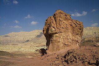
A mushroom rock, also called rock pedestal, or a pedestal rock, is a naturally occurring rock whose shape, as its name implies, resembles a mushroom. The rocks are deformed in a number of different ways: by erosion and weathering, glacial action, or from a sudden disturbance. Mushroom rocks are related to, but different from, yardang.

Parent material is the underlying geological material in which soil horizons form. Soils typically inherit a great deal of structure and minerals from their parent material, and, as such, are often classified based upon their contents of consolidated or unconsolidated mineral material that has undergone some degree of physical or chemical weathering and the mode by which the materials were most recently transported.

<span class="mw-page-title-main">Plucking (glaciation)</span> Glacial erosion of bedrock

Plucking, also referred to as quarrying, is a glacial phenomenon that is responsible for the weathering and erosion of pieces of bedrock, especially large "joint blocks". This occurs in a type of glacier called a "valley glacier". As a glacier moves down a valley, friction causes the basal ice of the glacier to melt and infiltrate joints (cracks) in the bedrock. The freezing and thawing action of the ice enlarges, widens, or causes further cracks in the bedrock as it changes volume across the ice/water phase transition, gradually loosening the rock between the joints. This produces large pieces of rock called joint blocks. Eventually these joint blocks come loose and become trapped in the glacier.

<span class="mw-page-title-main">Outwash fan</span> Type of sediment deposition by a melting glacier

An outwash fan is a fan-shaped body of sediments deposited by braided streams from a melting glacier. Sediment locked within the ice of the glacier gets transported by the streams of meltwater, and deposits on the outwash plain, at the terminus of the glacier. The outwash, the sediment transported and deposited by the meltwater and that makes up the fan, is usually poorly sorted due to the short distance traveled before being deposited.

<span class="mw-page-title-main">Sediment transport</span> Movement of solid particles, typically by gravity and fluid entrainment

Sediment transport is the movement of solid particles (sediment), typically due to a combination of gravity acting on the sediment, and the movement of the fluid in which the sediment is entrained. Sediment transport occurs in natural systems where the particles are clastic rocks, mud, or clay; the fluid is air, water, or ice; and the force of gravity acts to move the particles along the sloping surface on which they are resting. Sediment transport due to fluid motion occurs in rivers, oceans, lakes, seas, and other bodies of water due to currents and tides. Transport is also caused by glaciers as they flow, and on terrestrial surfaces under the influence of wind. Sediment transport due only to gravity can occur on sloping surfaces in general, including hillslopes, scarps, cliffs, and the continental shelf—continental slope boundary.

Attrition is the process of erosion that occurs during rock collision and transportation. The transportation of sediment chips and smooths the surfaces of bedrock; this can be through water or wind. Rocks undergoing attrition erosion are often found on or near the bed of a stream. Attrition is also partially responsible for turning boulders into smaller rocks and eventually to sand.

Aeolian landforms are features produced by either the erosive or depositive action of the wind. These features may be built up from sand or snow, or eroded into rock, snow, or ice. Aeolian landforms are commonly observed in sandy deserts and on frozen lakes or sea ice and have been observed and studied across Earth and on other planets, including Mars and Pluto

<span class="mw-page-title-main">Bedrock river</span> Type of river

A bedrock river is a river that has little to no alluvium mantling the bedrock over which it flows. However, most bedrock rivers are not pure forms; they are a combination of a bedrock channel and an alluvial channel. The way one can distinguish between bedrock rivers and alluvial rivers is through the extent of sediment cover.

<span class="mw-page-title-main">Roundness (geology)</span> The smoothness of clastic particles

Roundness is the degree of smoothing due to abrasion of sedimentary particles. It is expressed as the ratio of the average radius of curvature of the edges or corners to the radius of curvature of the maximum inscribed sphere.

<span class="mw-page-title-main">Loess Plateau</span> Plateau in north/northwest China

The Chinese Loess Plateau, or simply the Loess Plateau, is a plateau in north-central China formed of loess, a clastic silt-like sediment formed by the accumulation of wind-blown dust. It is located southeast of the Gobi Desert and is surrounded by the Yellow River. It includes parts of the Chinese provinces of Gansu, Shaanxi and Shanxi. The depositional setting of the Chinese Loess Plateau was shaped by the tectonic movement in the Neogene period, after which strong southeast winds caused by the East Asian Monsoon transported sediment to the plateau during the Quaternary period. The three main morphological types in the Loess Plateau are loess platforms, ridges and hills, formed by the deposition and erosion of loess. Most of the loess comes from the Gobi Desert and other nearby deserts. The sediments were transported to the Loess Plateau during interglacial periods by southeasterly prevailing winds and winter monsoon winds. After the deposition of sediments on the plateau, they were gradually compacted to form loess under the arid climate.

References

  1. Westgate, Lewis G. (February 1907). "Abrasion by Glaciers, Rivers, and Waves". The Journal of Geology. 15 (2): 113–120. Bibcode:1907JG.....15..113W. doi: 10.1086/621381 . S2CID   129042164.
  2. Monroe, James Stewart, Reed Wicander, & Richard W. Hazlett. (2011) Physical Geology: Exploring the Earth. Cengage Learning ISBN   9781111795658. pg 465,591
  3. Bennett, Matthew M.; Glasser, Neil F. (2011). "Glacial abrasion". Glacial Geology: Ice Sheets and Landforms. John Wiley & Sons. pp. 109–116. ISBN   978-1-119-96669-2.
  4. Chatanantavet, Phairot; Parker, Gary (25 November 2009). "Physically based modeling of bedrock incision by abrasion, plucking, and macroabrasion". Journal of Geophysical Research. 114 (F4): F04018. Bibcode:2009JGRF..114.4018C. doi: 10.1029/2008JF001044 .
  5. Whipple, Kelin X.; Hancock, Gregory S.; Anderson, Robert S. (1 March 2000). "River incision into bedrock: Mechanics and relative efficacy of plucking, abrasion, and cavitation". GSA Bulletin. 112 (3): 490–503. Bibcode:2000GSAB..112..490W. doi:10.1130/0016-7606(2000)112<490:RIIBMA>2.0.CO;2.
  6. Allan, J. D. & Castillo, M. M. (2007). Stream ecology: the structure and function of running waters. Springer Science & Business Media. ISBN   978-1-4020-5582-9.[ page needed ]
  7. Zhang, Keqi; Douglas, Bruce C.; Leatherman, Stephen P. (1 May 2004). "Global Warming and Coastal Erosion". Climatic Change. 64 (1): 41. doi:10.1023/B:CLIM.0000024690.32682.48. S2CID   154185819.
  8. Temmerman, Stijn; Meire, Patrick; Bouma, Tjeerd J.; Herman, Peter M. J.; Ysebaert, Tom; De Vriend, Huib J. (December 2013). "Ecosystem-based coastal defence in the face of global change". Nature. 504 (7478): 79–83. Bibcode:2013Natur.504...79T. doi:10.1038/nature12859. PMID   24305151. S2CID   4462888.
  9. 1 2 Krabbendam, Maarten; Glasser, Neil F. (July 2011). "Glacial erosion and bedrock properties in NW Scotland: Abrasion and plucking, hardness and joint spacing" (PDF). Geomorphology. 130 (3–4): 374–383. Bibcode:2011Geomo.130..374K. doi:10.1016/j.geomorph.2011.04.022.
  10. Iverson, Neal R. (1 October 1991). "Morphology of glacial striae: Implications for abrasion of glacier beds and fault surfaces". GSA Bulletin. 103 (10): 1308–1316. Bibcode:1991GSAB..103.1308I. doi:10.1130/0016-7606(1991)103<1308:MOGSIF>2.3.CO;2.
  11. Perkins, Jonathan P.; Finnegan, Noah J.; de Silva, Shanaka L. (April 2015). "Amplification of bedrock canyon incision by wind". Nature Geoscience. 8 (4): 305–310. Bibcode:2015NatGe...8..305P. doi:10.1038/ngeo2381.
  12. Okin, G.S.; Gillette, D.A.; Herrick, J.E. (April 2006). "Multi-scale controls on and consequences of aeolian processes in landscape change in arid and semi-arid environments". Journal of Arid Environments. 65 (2): 253–275. Bibcode:2006JArEn..65..253O. doi:10.1016/j.jaridenv.2005.06.029.