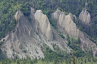
Sedimentary rocks are types of rock that are formed by the accumulation or deposition of mineral or organic particles at the Earth's surface, followed by cementation. Sedimentation is the collective name for processes that cause these particles to settle in place. The particles that form a sedimentary rock are called sediment, and may be composed of geological detritus (minerals) or biological detritus. The geological detritus originated from weathering and erosion of existing rocks, or from the solidification of molten lava blobs erupted by volcanoes. The geological detritus is transported to the place of deposition by water, wind, ice or mass movement, which are called agents of denudation. Biological detritus was formed by bodies and parts of dead aquatic organisms, as well as their fecal mass, suspended in water and slowly piling up on the floor of water bodies. Sedimentation may also occur as dissolved minerals precipitate from water solution.

Sediment is a naturally occurring material that is broken down by processes of weathering and erosion, and is subsequently transported by the action of wind, water, or ice or by the force of gravity acting on the particles. For example, sand and silt can be carried in suspension in river water and on reaching the sea bed deposited by sedimentation; if buried, they may eventually become sandstone and siltstone through lithification.

A braided river, or braided channel, consists of a network of river channels separated by small, often temporary, islands called braid bars or, in English usage, aits or eyots. Braided streams tend to occur in rivers with high sediment loads and/or coarse grain sizes, and in rivers with steeper slopes than typical rivers with straight or meandering channel patterns. They are also associated with rivers with rapid and frequent variation in the amount of water they carry, i.e., with "flashy" rivers, and with rivers with weak banks. Braided channels are found in a variety of environments all over the world, including gravelly mountain streams, sand bed rivers, on alluvial fans, on river deltas, and across depositional plains.

An alluvial fan is an accumulation of sediments shaped like a section of a shallow cone, with its apex at a point source of sediments, such as a narrow canyon emerging from an escarpment. They are characteristic of mountainous terrain in arid to semiarid climates, but are also found in more humid environments subject to intense rainfall and in areas of modern glaciation. They range in area from less than 1 square kilometre (0.39 sq mi) to almost 20,000 square kilometres (7,700 sq mi).

In geography and geology, fluvial processes are associated with rivers and streams and the deposits and landforms created by them. When the stream or rivers are associated with glaciers, ice sheets, or ice caps, the term glaciofluvial or fluvioglacial is used.

Placer mining is the mining of stream bed (alluvial) deposits for minerals. This may be done by open-pit or by various surface excavating equipment or tunneling equipment.
Landforms are categorized by characteristic physical attributes such as their creating process, shape, elevation, slope, orientation, rock exposure, and soil type.

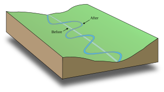
A meander is one of a series of regular sinuous curves, bends, loops, turns, or windings in the channel of a river, stream, or other watercourse. It is also a term for walking slowly. It is produced by a stream or river swinging from side to side as it flows across its floodplain or shifts its channel within a valley. A meander is produced by a stream or river as it erodes the sediments comprising an outer, concave bank and deposits this and other sediment downstream on an inner, convex bank which is typically a point bar. The result of sediments being eroded from the outside concave bank and their deposition on an inside convex bank is the formation of a sinuous course as a channel migrates back and forth across the down-valley axis of a floodplain. The zone within which a meandering stream shifts its channel across either its floodplain or valley floor from time to time is known as a meander belt. It typically ranges from 15 to 18 times the width of the channel. Over time, meanders migrate downstream, sometimes in such a short time as to create civil engineering problems for local municipalities attempting to maintain stable roads and bridges.
A wide variety of river and stream channel types exist in limnology, the study of inland waters. All these can be divided into two groups by using the water-flow gradient as either low gradient channels for streams or rivers with less than two percent (2%) flow gradient, or high gradient channels for those with greater than a 2% gradient.

Clastic rocks are composed of fragments, or clasts, of pre-existing minerals and rock. A clast is a fragment of geological detritus, chunks and smaller grains of rock broken off other rocks by physical weathering. Geologists use the term clastic with reference to sedimentary rocks as well as to particles in sediment transport whether in suspension or as bed load, and in sediment deposits.

Upland and lowland are conditional descriptions of a plain based on elevation above sea level. In studies of the ecology of freshwater rivers, habitats are classified as upland or lowland.

A riffle is a shallow landform in a flowing channel, and it has specific topographic, sedimentary, and hydraulic indicators. These are almost always assessed at a very low discharge compared to the flow that fills the channel, and as a result the water moving over a riffle appears shallow and fast, with a wavy, disturbed water surface. The water's surface over a riffle at low flow also has a much steeper slope than that over other in-channel landforms. Channel sections with a mean water surface slope of roughly 0.1 to 0.5% exhibit riffles, though they can occur in steeper or gentler sloping channels with coarser or finer bed materials, respectively. Except in the period after a flood, the sediment on the riverbed in a riffle is usually much coarser than on that in any other in-channel landform.

In geology, depositional environment or sedimentary environment describes the combination of physical, chemical and biological processes associated with the deposition of a particular type of sediment and, therefore, the rock types that will be formed after lithification, if the sediment is preserved in the rock record. In most cases the environments associated with particular rock types or associations of rock types can be matched to existing analogues. However, the further back in geological time sediments were deposited, the more likely that direct modern analogues are not available.

A stream pool, in hydrology, is a stretch of a river or stream in which the water depth is above average and the water velocity is below average.

A point bar is a depositional feature made of alluvium that accumulates on the inside bend of streams and rivers below the slip-off slope. Point bars are found in abundance in mature or meandering streams. They are crescent-shaped and located on the inside of a stream bend, being very similar to, though often smaller than, towheads, or river islands.

A bar in a river is an elevated region of sediment that has been deposited by the flow. Types of bars include mid-channel bars, point bars, and mouth bars. The locations of bars are determined by the geometry of the river and the flow through it. Bars reflect sediment supply conditions, and can show where sediment supply rate is greater than the transport capacity.
An alluvial river is one in which the bed and banks are made up of mobile sediment and/or soil. Alluvial rivers are self-formed, meaning that their channels are shaped by the magnitude and frequency of the floods that they experience, and the ability of these floods to erode, deposit, and transport sediment. For this reason, alluvial rivers can assume a number of forms based on the properties of their banks; the flows they experience; the local riparian ecology; and the amount, size, and type of sediment that they carry.

Mylopharadon conocephalus, known as the hardhead, is a freshwater ray-finned fish from the family Cyprinidae, the carps and minnows, which is endemic to California. It is the sole member of the monotypic genus Mylopharadon.
The scarlet shiner is a freshwater fish native to the eastern United States.

Glaciofluvial deposits or Glacio-fluvial sediments consist of boulders, gravel, sand, silt and clay from ice sheets or glaciers. They are transported, sorted and deposited by streams of water. The deposits are formed beside, below or downstream from the ice. They include kames, kame terraces and eskers formed in ice contact and outwash fans and outwash plains below the ice margin. Typically the outwash sediment is carried by fast and turbulent fluvio-glacial meltwater streams, but occasionally it is carried by catastrophic outburst floods. Larger elements such as boulders and gravel are deposited nearer to the ice margin, while finer elements are carried farther, sometimes into lakes or the ocean. The sediments are sorted by fluvial processes. They differ from glacial till, which is moved and deposited by the ice of the glacier, and is unsorted.


