Little North Santiam River

Last updated
Little North Santiam River
Name origin:For the Santiam people, a Kalapuya tribe that lived near the Santiam River until removal to the Grande Ronde Reservation in 1906. [1]
Country United States
State Oregon
County Marion
Sourceconfluence of Battle Ax and Opal creeks
 - location Cascade Range
 - elevation2,085 ft (636 m) [2]
 - coordinates 44°50′48″N122°12′33″W / 44.84667°N 122.20917°W / 44.84667; -122.20917   [3]
Mouth North Santiam River
 - locationnear Mehama
 - elevation619 ft (189 m) [3]
 - coordinates 44°47′05″N122°36′30″W / 44.78472°N 122.60833°W / 44.78472; -122.60833 Coordinates: 44°47′05″N122°36′30″W / 44.78472°N 122.60833°W / 44.78472; -122.60833   [3]
Length27 mi (43 km) [4]
Basin113 sq mi (293 km2) [4]
Discharge
 - average746 cu ft/s (21 m3/s) [4]
USA Oregon location map.svg
Red pog.svg
Location of the mouth of the Little North Santiam River in Oregon

The Little North Santiam River is a 27-mile (43 km) tributary of the North Santiam River in western Oregon in the United States. [4] It drains 113 square miles (290 km2) of the Cascade Range on the eastern side of the Willamette Valley east of Salem. [4]

North Santiam River river in the United States of America

The North Santiam River is a 92-mile (148 km) tributary of the Santiam River in western Oregon in the United States. It drains 766 square miles (1,980 km2) of the Cascade Range on the eastern side of the Willamette Valley east of Salem.

Oregon State of the United States of America

Oregon is a state in the Pacific Northwest region on the West Coast of the United States. The Columbia River delineates much of Oregon's northern boundary with Washington, while the Snake River delineates much of its eastern boundary with Idaho. The parallel 42° north delineates the southern boundary with California and Nevada. Oregon is one of only three states of the contiguous United States to have a coastline on the Pacific Ocean.

Cascade Range mountain range in western North America

The Cascade Range or Cascades is a major mountain range of western North America, extending from southern British Columbia through Washington and Oregon to Northern California. It includes both non-volcanic mountains, such as the North Cascades, and the notable volcanoes known as the High Cascades. The small part of the range in British Columbia is referred to as the Canadian Cascades or, locally, as the Cascade Mountains. The latter term is also sometimes used by Washington residents to refer to the Washington section of the Cascades in addition to North Cascades, the more usual U.S. term, as in North Cascades National Park. The highest peak in the range is Mount Rainier in Washington at 14,411 feet (4,392 m).

Contents

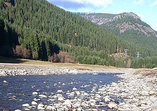
The river begins in the Opal Creek Wilderness at the confluence of Battle Ax and Opal creeks in Willamette National Forest and flows generally west-southwest through forests within Marion County to meet the larger river near Mehama. [5] North Fork Road runs along the stream's lower reaches until it meets Forest Road 2209, which continues upstream to Opal Creek Trailhead. [4]

Opal Creek Wilderness

The Opal Creek Wilderness is a wilderness area located in the Willamette National Forest in the U.S. state of Oregon, on the border of the Mount Hood National Forest. It has the largest uncut watershed in Oregon.

Willamette National Forest United States national forest in Oregon

The Willamette National Forest is a National Forest located in the central portion of the Cascade Range of the U.S. state of Oregon. It comprises 1,678,031 acres (6,790.75 km2), making it one of the largest national forests. Over 380,000 acres are designated wilderness which include seven major mountain peaks. There are also several National Wild and Scenic Rivers within the forest. The forest is named for the Willamette River, which has its headwaters in the forest. The forest headquarters are located in the city of Springfield. There are local ranger district offices in McKenzie Bridge, Detroit, Sweet Home, and Westfir.

Marion County, Oregon County in the United States

Marion County is a county located in the U.S. state of Oregon. The population was 315,335 at the 2010 census, making it the fifth-most populous county in Oregon. The county seat is Salem, the state capital. The county was originally named the Champooick District, after Champoeg, a meeting place on the Willamette River. On September 3, 1849, the territorial legislature renamed it in honor of Francis Marion, a Continental Army general from South Carolina who served in the American Revolutionary War.

Named tributaries from source to mouth are Opal, Battle Ax, Gold, Horn, Tincup, Cold, Stack, Cedar, and Little Cedar creeks. Then come Dry, Henline, Evans, Fawn, Elkhorn, Fish, Sinker, Moorehouse, and Big creeks. Further downstream are Cougar, Bear, Canyon, Kiel, Beaver, Jeeter, Cox, and Polly creeks. [5]

Elkhorn Creek (Marion County, Oregon)

Elkhorn Creek is a 7.6-mile (12 km) long stream in Marion County, Oregon, United States. Its source is on the northern edge of the Willamette National Forest, about 3.5 miles (5.6 km) north of Big Cliff Reservoir. The creek flows mostly west, receiving Big Twelve Creek, Buckhorn Creek, and Buck Creek all from the south, and it enters the Little North Santiam River just south of Elkhorn Woods Park, about 5 miles (8.0 km) north of the city of Gates. The stream's valley is surrounded by the western Cascade foothills, covered with coniferous trees characteristic of the Pacific Northwest, and lined with red alders at the water's edge. The creek supports runs of rainbow and coastal cutthroat trout, as well as Pacific giant salamanders. On September 30, 1996, a 6.4-mile (10.3 km) portion of the stream, from the mouth nearly to the source, was protected as part of the National Wild and Scenic Rivers System.

Recreation

Camping and day-use

Shady Cove Campground, managed by the United States Forest Service, is in the Opal Creek Scenic Recreation Area of Willamette National Forest along the upper river. Shady Cove's amenities include limited parking, sites for tent and trailer camping, picnic tables, toilets, and access to hiking trails but no drinking water. The campground is open all year but may be blocked by snow in winter and can be quite wet in April and May. [6]

United States Forest Service federal forest and grassland administrators

The United States Forest Service (USFS) is an agency of the U.S. Department of Agriculture that administers the nation's 154 national forests and 20 national grasslands, which encompass 193 million acres (780,000 km2). Major divisions of the agency include the National Forest System, State and Private Forestry, Business Operations, and the Research and Development branch. Managing approximately 25% of federal lands, it is the only major national land agency that is outside the U.S. Department of the Interior.

Downriver from Shady Cove is the Three Pools Day Use Area, also managed by the Forest Service. About 15,000 people visit the site annually. The area features "three spectacular emerald pools", [7] used for swimming in the river. Amenities include picnic sites and restrooms but no drinking water. [7]

Further downstream is Salmon Falls Park, a county park of 23 acres (9.3 ha). It is a day-use site that features a 30-foot (9 m) waterfall. Amenities include picnic tables, a restroom, and access to the river and to hiking trails. The park is open from May 1 to October 31. [8]

On down the river from Salmon Falls, the Bureau of Land Management (BLM) oversees the Little North Santiam Recreation Area and its Elkhorn Valley Recreation Site, which has 23 tent and trailer campsites, 4 picnic sites, parking, toilets, drinking water, and access to trails and river beaches. Canyon Creek Recreation Site, a separate day-use park managed by the BLM, has 15 picnic sites, a sandy river beach, drinking water, parking, and toilets. Both sites are generally open from Memorial Day through Labor Day. [9]

Bear Creek Park, operated by Marion County, lies on about 15 acres (6.1 ha) of land between the two BLM sites. Open from May 1 through October 31, it has 15 campsites with amenities including parking, a campground host, picnic tables, fire pits, a restroom, and access to the river and a hiking trail. [10]

Further downstream is North Fork Park, a 12-acre (4.9 ha) day-use area managed by Marion County. Open from May 1 through October 31, it has picnic tables, river access, hiking trails, and a restroom. [11]

Fishing

The river supports populations of rainbow trout (including runs of steelhead), as well as cutthroat trout. Trout fishing, best along the stream's upper reaches, is catch and release. Chinook salmon also frequent the river, but fishing for them on the Little North Santiam is not allowed. [12]

See also

Related Research Articles

Foster Reservoir

Foster Reservoir is a reservoir created by Foster Dam on the South Santiam River in the city of Foster, Oregon, United States. The reservoir is approximately 5.6 km (3.5 mi) long and covers approximately 494 ha when full. Primary use of the reservoir is recreation in the summer and flood control in the winter and spring.

Salmon River (Clackamas County, Oregon) river in Oregons Cascade Range

The Salmon River is a 33.5-mile (53.9 km) river in the Cascade Range in the U.S. state of Oregon that drains part of southwestern Mount Hood. The entire length of the river is a protected National Wild and Scenic River. Several portions are in protected wilderness. It is affluent to the Sandy River, a tributary of the Columbia River.

Crooked River (Oregon) tributary of the Deschutes River in the U.S. state of Oregon

The Crooked River is a tributary, 125 miles (201 km) long, of the Deschutes River in the U.S. state of Oregon. The river begins at the confluence of the South Fork Crooked River and Beaver Creek. Of the two tributaries, the South Fork Crooked River is the larger and is sometimes considered part of the Crooked River proper. A variant name of the South Fork Crooked River is simply "Crooked River". The Deschutes River flows north into the Columbia River.

Santiam State Forest

Santiam State Forest is one of six state forests managed by the Oregon Department of Forestry. The forest is located approximately 25 miles (40 km) southeast of Salem, Oregon, and includes 47,871 acres (193.73 km2) on the western slope of the Cascade Mountains in three Oregon counties: Clackamas, Linn, and Marion. It is bounded on the east by the Willamette National Forest and Mount Hood National Forest. Silver Falls State Park is located west of the forest. The rest of the land surrounding the forest belongs to the Bureau of Land Management or is privately owned. The forest is managed as part of the Department of Forestry's North Cascade District. It is the largest single block of state owned forest land in the Cascades.

Brushy Creek State Recreation Area

Brushy Creek State Recreation Area is a state park in Webster County, Iowa in the United States. With an area encompassing over 6,000 acres (24 km2), the facility is one of Iowa's largest public outdoor recreation areas.

Bandon State Natural Area

Bandon State Natural Area is a state park in the U.S. state of Oregon. It is administered by the Oregon Parks and Recreation Department. The 879-acre (356 ha) park lies west of U.S. Route 101, off Beach Loop Drive, about 5 miles (8 km) south of Bandon. The Oregon Coast Trail passes through the park.

Cascadia State Park

Cascadia State Park is a state park in the U.S. state of Oregon near Sweet Home along the South Santiam River at Cascadia. The park includes a day use area, campsites, hiking trails and 150 foot Lower Soda Creek Falls.

Catherine Creek river in the United States of America

Catherine Creek is a 32.4-mile-long (52.1 km) creek in northeastern Oregon, United States. A tributary of the Grande Ronde River, it is the second-longest stream in the Grande Ronde Valley. Originating in the foothills of the Wallowa Mountains, it flows generally northwest through Catherine Creek State Park and the city of Union before joining the river.

Suttle Lake (Oregon) lake in Oregon, United States of America

Suttle Lake is a natural lake near the crest of the Cascade Range in central Oregon, United States, covering 253 acres (1.02 km2). It was named in honor of John Settle, whose name was misspelled when the lake was officially recorded as a geographic feature. Today, the lake is located within the Deschutes National Forest and serves as one of central Oregon's most popular outdoor recreation sites, with three large campgrounds and two day-use areas along the south shore of the lake. The Oregon Department of Fish and Wildlife regularly stocks the lake with rainbow trout.

Hills Creek Reservoir

Hills Creek Reservoir, also known as Hills Creek Lake, is an artificial impoundment behind Hills Creek Dam on the Middle Fork Willamette River in the U.S. state of Oregon. The lake is near Oakridge in Lane County about 40 miles (64 km) southeast of Eugene, at the confluence of Hills Creek with the Middle Fork. The reservoir and its watershed lie within the Willamette National Forest.

Powhatan State Park

Powhatan State Park is a state park located along the James River in Virginia. It is in Powhatan County. The park is 1,565 acres (6 km2) total with a 2-mile (3.2 km) of riverfront.

Roaring River (South Fork McKenzie River tributary)

Roaring River is a tributary of the South Fork McKenzie River in Lane County in the U.S. state of Oregon. It begins along the west side of Roaring River Ridge in the Cascade Range and flows generally north through the Willamette National Forest to meet the larger stream about 22 miles (35 km) from its confluence with the McKenzie River.

South Fork Burnt River river in the United States of America

The South Fork Burnt River is a tributary of the Burnt River in Baker County in the U.S. state of Oregon. Its headwaters lie in the Monument Rock Wilderness and the Wallowa–Whitman National Forest of the Blue Mountains. It flows generally northeast for about to meet the main stem at Unity Reservoir, north of Unity. The river, about 12 miles (19 km) long, crosses under U.S. Route 26 about 3 miles (5 km) northwest of Unity.

North Fork Umatilla River river in the United States of America

The North Fork Umatilla River is a tributary of the Umatilla River in Union and Umatilla counties in the U.S. state of Oregon. Its headwaters lie in the Umatilla National Forest in the Blue Mountains of northeastern Oregon. It flows generally northwest to meet the South Fork Umatilla River near Graves Butte. Together the two forks form the main stem Umatilla.

Little Minam River river in the United States of America

The Little Minam River is a tributary of the Minam River in Union County in the U.S. state of Oregon. It begins at the base of Cartwheel Ridge in the Wallowa Mountains and flows generally north through the Wallowa–Whitman National Forest to meet the main stem river at the north end of Backbone Ridge.

Eagle Creek (Powder River)

Eagle Creek is a tributary, 41 miles (66 km) long, of the Powder River in the northeastern part of the U.S. state of Oregon. Beginning at Eagle Lake in the Wallowa Mountains, the creek flows generally southwest and then southeast to meet the river near the small city of Richland. The creek's headwaters are in the Eagle Cap Wilderness within the Wallowa–Whitman National Forest. The upper 28.9 miles (46.5 km) of the creek, from Eagle Lake to the national forest boundary at Skull Creek, are part of the National Wild and Scenic Rivers System.

Fall Creek (Middle Fork Willamette River)

Fall Creek is a 34-mile (55 km) tributary of the Middle Fork Willamette River in Lane County in the U.S. state of Oregon. Beginning in the Cascade Range, the creek flows generally west through the Willamette National Forest to enter the Middle Fork upstream of Jasper, southeast of Springfield and Eugene.

Cavitt Creek river in the United States of America

Cavitt Creek is a tributary of the Little River in Douglas County in the U.S. state of Oregon. From its source near Red Butte, the creek flows generally west then north through the Umpqua National Forest of the Cascade Range before entering the river about 1.5 miles (2.4 km) upstream of the rural community of Peel and 7 miles (11 km) above the Little River's mouth on the North Umpqua River.

Eagle Creek Upper Falls

Eagle Creek Upper Falls, also called Upper Eagle Creek Falls, is a small waterfall located in Clackamas County, in the U.S. state of Oregon. The waterfall is known for a fish ladder that bypasses the waterfall to assist fish navigate the waterfall. Eagle Creek is known for being a point for fishing chinook salmon, bull trout, and steelhead trout.

References

  1. McArthur, Lewis A.; McArthur, Lewis L. (2003). Oregon Geographic Names (7th ed.). Portland, Oregon: Oregon Historical Society Press. p. 848. ISBN   0-87595-277-1.
  2. Google Earth elevation for GNIS coordinates
  3. 1 2 3 "Little North Santiam River". Geographic Names Information System (GNIS). United States Geological Survey. November 28, 1980. Retrieved March 5, 2016.
  4. 1 2 3 4 5 6 Palmer, Tim (2014). Field Guide to Oregon Rivers. Corvallis: Oregon State University Press. pp. 184–86. ISBN   978-0-87071-627-0.
  5. 1 2 "United States Topographic Map". United States Geological Survey. Retrieved March 5, 2016 via Acme Mapper.
  6. "Shady Cove Campground". United States Forest Service. Retrieved March 6, 2016.
  7. 1 2 "Three Pools Day Use Area". United States Forest Service. Retrieved March 8, 2016.
  8. "Salmon Falls". Marion County, Oregon. Retrieved March 6, 2016.
  9. "Little North Santiam Recreation Area" (PDF). Bureau of Land Management. Retrieved March 6, 2016.
  10. "Bear Creek". Marion County, Oregon. 2015. Retrieved March 6, 2016.
  11. "North Fork Park". Marion County, Oregon. Retrieved March 8, 2016.
  12. Sheehan, Madelynne Diness. Fishing in Oregon: The Complete Oregon Fishing Guide (10th ed.). Scappoose, Oregon: Flying Pencil Publications. p. 171. ISBN   0-916473-15-5.