
The Okanogan National Forest is a U.S. National Forest located in Okanogan County in north-central Washington, United States.

Olympic National Forest is a U.S. National Forest located in Washington, USA. With an area of 628,115 acres (2,541.89 km2), it nearly surrounds Olympic National Park and the Olympic Mountain range. Olympic National Forest contains parts of Clallam, Grays Harbor, Jefferson, and Mason counties. The landscape of the national forest varies, from the temperate Olympic rain forest to the salt water fjord of Hood Canal to the peaks of Mt. Washington.
The Willamette National Forest is a National Forest located in the central portion of the Cascade Range of the U.S. state of Oregon. It comprises 1,678,031 acres (6,790.75 km2). Over 380,000 acres are designated wilderness which include seven major mountain peaks. There are also several National Wild and Scenic Rivers within the forest. The forest is named for the Willamette River, which has its headwaters in the forest. The forest headquarters are located in the city of Springfield. There are local ranger district offices in McKenzie Bridge, Detroit, Sweet Home, and Westfir.

The Malheur National Forest is a National Forest in the U.S. state of Oregon. It contains more than 1.4 million acres (5,700 km2) in the Blue Mountains of eastern Oregon. The forest consists of high desert grasslands, sage, juniper, pine, fir, and other tree species. Elevations vary from about 4,000 feet (1,200 m) to the 9,038-foot (2,755 m) peak of Strawberry Mountain. The Strawberry Mountains extend east to west through the center of the forest. U.S. Route 395 runs south to north through the forest, while U.S. Route 26 runs east to west.

The Mount Hood National Forest is 62 miles (100 km) east of the city of Portland, Oregon, and the northern Willamette River valley. The Forest extends south from the Columbia River Gorge across more than 60 miles (97 km) of forested mountains, lakes and streams to the Olallie Scenic Area, a high lake basin under the slopes of Mount Jefferson. The Forest includes and is named after Mount Hood, a stratovolcano. The Forest encompasses some 1,067,043 acres (4,318.17 km2). Forest headquarters are located in Sandy, Oregon. A 1993 Forest Service study estimated that the extent of old growth in the Forest was 345,300 acres (139,700 ha). The Forest is divided into four separate districts - Barlow, Clackamas River (Estacada), Hood River, and Zigzag (Zigzag).

The Shasta–Trinity National Forests are federally designated forests in northern California, United States. Combined, they are the largest National Forest in California and are managed by the U.S. Forest Service. The 2,210,485 acre combined-forest encompasses five wilderness areas, hundreds of mountain lakes and 6,278 miles (10,103 km) of streams and rivers. Major features include Shasta Lake, the largest man-made lake in California and Mount Shasta, elevation 14,179 feet (4,322 m).

The Hells Canyon Wilderness is a wilderness area in the western United States, in Idaho and Oregon. Created 46 years ago in 1975, the Wilderness is managed by both the U.S. Bureau of Land Management and the U.S. Forest Service and contains some of the most spectacular sections of the Snake River as it winds its way through Hells Canyon, North America's deepest river gorge and one of the deepest gorges on Earth. The Oregon Wilderness Act of 1984 added additional acreage and currently the area protects a total area of 217,927 acres (88,192 ha). It lies entirely within the Hells Canyon National Recreation Area except for a small 946-acre (383 ha) plot in southeastern Wallowa County, Oregon which is administered by the Bureau of Land Management. The area that is administered by the Forest Service consists of portions of the Wallowa, Nez Perce, Payette, and Whitman National Forests.

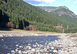
Norse Peak Wilderness is a 52,315-acre (21,171 ha) designated wilderness area located in central Washington in the United States. It protects the portion of the Cascade Range north of Chinook Pass, south of Naches Pass, and east of Mount Rainier National Park. It is bordered by the William O. Douglas Wilderness to the south. The wilderness is named for a prominent peak which overlooks Crystal Mountain Ski Area. Roughly triangular, it is about 10 miles (16 km) across and contains no roads.
The Ventana Wilderness of Los Padres National Forest is a federally designated wilderness area located in the Santa Lucia Range along the Central Coast of California. This wilderness was established in 1969 when the Ventana Wilderness Act redesignated the 55,800-acre (22,600 ha) Ventana Primitive Area as the Ventana Wilderness and added land, totalling 98,000 acres (40,000 ha). In 1978, the Endangered American Wilderness Act added 61,000 acres (25,000 ha), increasing the total wilderness area to about 159,000 acres (64,000 ha). The California Wilderness Act of 1984 added about 2,750 acres (1,113 ha). The Los Padres Condor Range and River Protection Act of 1992 created the approximately 14,500-acre (5,900 ha) Silver Peak Wilderness and added about 38,800 acres (15,700 ha) to the Ventana Wilderness in addition to designating the Big Sur River as a Wild and Scenic River. The Big Sur Wilderness and Conservation Act of 2002 expanded the wilderness for the fifth time, adding nearly 35,000 acres (14,000 ha), increasing the total acreage of the wilderness to its present size of 240,026 acres (97,135 ha).

Umpqua National Forest, in southern Oregon's Cascade Range, covers an area of 983,129 acres (3,978.58 km2) in Douglas, Lane, and Jackson counties, and borders Crater Lake National Park. The four ranger districts for the forest are the Cottage Grove, Diamond Lake, North Umpqua, and Tiller ranger districts. The forest is managed by the United States Forest Service, headquartered in Roseburg.

The Deschutes National Forest is a United States National Forest located in parts of Deschutes, Klamath, Lake, and Jefferson counties in central Oregon. It comprises 1.8 million acres (7,300 km2) along the east side of the Cascade Range. In 1908, the Deschutes National Forest was established from parts of the Blue Mountains, Cascade, and Fremont National Forests. In 1911, parts of the Deschutes National Forest were split off to form the Ochoco and Paulina National Forests, and parts of the Cascade and Oregon National Forests were added to the Deschutes. In 1915, the lands of the Paulina National Forest were rejoined to the Deschutes National Forest. A 1993 Forest Service study estimated that the extent of old growth in the forest was 348,100 acres (140,900 ha). Within the boundaries of the Deschutes National Forest is the Newberry National Volcanic Monument, containing cinder cones, lava flows, and lava tubes. The Deschutes National Forest as a whole contains in excess of 250 known caves. The forest also contains five wilderness areas, six National Wild and Scenic Rivers, the Oregon Cascade Recreation Area, and the Metolius Conservation Area. Forest headquarters are located in Bend, Oregon. There are local ranger district offices in Bend, Crescent, and Sisters.

The North Fork John Day Wilderness is a wilderness area within the Umatilla and Wallowa–Whitman National Forests in the Blue Mountains of northeastern Oregon.

The Salmon–Huckleberry Wilderness is a wilderness area located on the southern side of Mount Hood in the northwestern Cascades of Oregon, in the United States. It lies within the Mount Hood National Forest and comprises 62,061 acres (25,115 ha) of land. The United States Congress designated the area Wilderness in 1984.

The Mark O. Hatfield Wilderness is a wilderness area located on the northern side of Mount Hood in the northwestern Cascades of the U.S. state of Oregon, near the Columbia River Gorge and within Mount Hood National Forest. Prior to Wilderness designation it was known as the Columbia Gorge Recreation Area.

The Badger Creek Wilderness is a 29,057-acre (11,759 ha) wilderness area located east of Mount Hood in the northwestern Cascades of Oregon, United States. It is one of six designated wilderness areas in the Mount Hood National Forest, the others being Mark O. Hatfield, Salmon-Huckleberry, Mount Hood, Mount Jefferson, and Bull of the Woods.

The Siuslaw National Forest is a national forest in western Oregon in the United States. Established in 1908, the Siuslaw is made up of a wide variety of ecosystems, ranging from coastal forests to sand dunes.

Eagle Cap Wilderness is a wilderness area located in the Wallowa Mountains of northeastern Oregon, within the Wallowa–Whitman National Forest. The wilderness was established in 1940. In 1964, it was included in the National Wilderness Preservation System. A boundary revision in 1972 added 73,000 acres (30,000 ha) and the Wilderness Act of 1964 added 66,100 acres (26,700 ha) resulting in a current total of 361,446 acres, making Eagle Cap by far Oregon's largest wilderness area.

Grassy Knob Wilderness is a wilderness area in the Klamath Mountains of southwestern Oregon, within the Rogue River-Siskiyou National Forest. It was designated wilderness by the United States Congress in 1984 and now comprises a total of 17,200 acres (6,961 ha). Like most wilderness areas in Oregon, Grassy Knob is managed by the Forest Service.

The French Pete Trail is a 9.9-mile (15.9 km) hiking trail in the valley of French Pete Creek in the Three Sisters Wilderness of western Oregon. The trail passes through low-elevation old-growth forest that was a nationwide political issue in the 1960s and 1970s because of conflicting plans for logging and for wilderness designation, respectively. In 1978, the U.S. Congress passed a bill adding the French Pete area to the Three Sisters Wilderness.
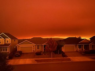
The Santiam Fire was a very large wildfire that burned in Marion, Jefferson, Linn, and Clackamas Counties, in northwest Oregon, United States. Having ignited in August of 2020, the 402,274-acre (162,795 ha) fire ravaged multiple communities in northwestern Oregon, before it was fully contained on December 10, 2020. The fire started as three separate fires. The Beachie Creek, Lionshead, and P-515 fires were ignited by lightning on August 16, 2020. The first three fires gradually grew in size, before explosively spreading in early September during a heatwave, fanned by powerful east winds. Early on September 8, the Beachie Creek and Lionshead Fires merged, and the combined fire was labeled the Santiam Fire, before being returned to their original names a couple of days later. The P-515 Fire merged into the Lionshead Fire a few days later. The Santiam Fire destroyed over 1,500 structures, including the cities of Detroit and Gates, with Idanha, Mill City, and Lyons suffering varying amounts of damage, becoming one of the most destructive wildfires in the recorded history of Oregon. The fire killed five people. On September 10–12, 2020, there were fears that the Santiam Fire would merge with the Riverside Fire to the north.

