
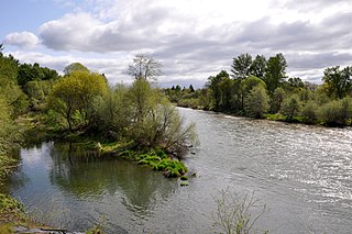
The Yaquina River is a stream, 59 miles (95 km) long, on the Pacific coast of the U.S. state of Oregon. It drains an area of the Central Oregon Coast Range west of the Willamette Valley near Newport.

Champoeg is a former town in the U.S. state of Oregon. Now a ghost town, it was an important settlement in the Willamette Valley in the early 1840s. Located halfway between Oregon City and Salem, it was the site of the first provisional government of the Oregon Country.
Yaquina Bay is a coastal estuarine community found in Newport, Oregon. Yaquina Bay is a semi-enclosed body of water, approximately 8 km² (3.2 mi²) in area, with free connection to the Pacific Ocean, but also diluted with freshwater from the Yaquina River land drainage. The Bay is traversed by the Yaquina Bay Bridge.
TouVelle State Recreation Site is a state park, administered by Oregon Parks and Recreation Department, and located in Jackson County, Oregon, United States, 9 miles (14 km) north of Medford, where Table Rock Road crosses the Rogue River. This 51-acre (210,000 m2) park is used for fishing, birding, hiking, picnicking and swimming. There is also a boat ramp, which lies at the lower end of an easily navigated stretch of the Rogue. A daily user-fee or annual permit is required.
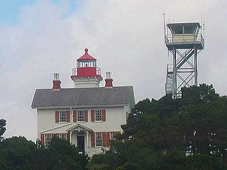
The Yaquina Bay Light is a lighthouse that was built in 1871, soon after the founding of the city of Newport, Oregon, in the United States. It is located on the north side of Yaquina Bay. In 1871–1874, it was the busiest and most populated of the many coastal ports between Washington and California.

Agate Beach is an unincorporated community in Lincoln County, Oregon, United States. Agate Beach is named for the agates that are found on the beaches of the Pacific Ocean between Newport and Yaquina Head. Agate Beach post office was established in 1912 and closed in 1971.

The Yachats State Recreation Area is a state park in southern Lincoln County, Oregon, in the central district of the town of Yachats. It is administered by the Oregon Parks and Recreation Department. It is located on the Pacific Ocean coast, on the north side of the mouth of the Yachats River. The park is open for day use only, and offers wildlife and surf viewing, tidepools, fishing, and picnicking.

Nehalem Bay State Park is a state park in the United States located on the Oregon Coast, near the communities of Nehalem and Manzanita on the Nehalem Spit, a sand spit west of Nehalem Bay.

Seal Rock is an unincorporated coastal community in Lincoln County, Oregon, United States, between Newport and Waldport on U.S. Route 101.

Moolack Beach is an undeveloped sandy beach on the Oregon Coast about 4 miles (6 km) north of Newport in Lincoln County, United States. It is almost 8 km (5 mi) in length with the south end at Yaquina Head and the north end at Otter Rock, the site of Devils Punch Bowl State Natural Area. The northern beach is the site of Beverly Beach State Park and the community of Beverly Beach. The beach has no obvious break delineating what would seem to be Beverly Beach, though Wade Creek is a likely candidate. The nearly ten-foot (3-metre) tidal range and seasonally varying slope of the beach can cause the sandy beach to completely disappear at times; at other times it can be hundreds of feet wide. The beach is bounded by U.S. Route 101.

Willamette Mission State Park is a state park in the U.S. state of Oregon, located about four miles (6 km) north of Keizer adjacent to the Wheatland Ferry and east of the Willamette River. It includes Willamette Station Site, Methodist Mission in Oregon, which is listed by the National Register of Historic Places.

Jackson F. Kimball State Recreation Site is a state park in southern Oregon. The park is operated and maintained by the Oregon Parks and Recreation Department, and is located approximately 20 miles (32 km) southeast of Crater Lake National Park and 3 miles (4.8 km) north of Fort Klamath. The park was established in 1955, and covers 19 acres (7.7 ha) including the headwaters of the Wood River.
Coquille Myrtle Grove State Natural Site is a state park administered by the Oregon Parks and Recreation Department in the U.S. state of Oregon. The park, bordering the Powers Highway between Myrtle Point and Powers, in Coos County, features a swimming hole and sandy beach along the South Fork Coquille River. Other amenities include parking, picnic tables, restrooms, and access to fishing but no drinking water.

Fogarty Creek State Recreation Area is a state park in the U.S. state of Oregon, administered by the Oregon Parks and Recreation Department.

Manhattan Beach State Recreation Site is a state park in the U.S. state of Oregon. Administered by the Oregon Parks and Recreation Department, the park is open to the public and is fee-free. Amenities at the park, which is 2 miles (3 km) north of Rockaway Beach along U.S. Route 101, include picnicking, fishing, and a Pacific Ocean beach.

Oceanside Beach State Recreation Site is a state park in the U.S. state of Oregon. Administered by the Oregon Parks and Recreation Department, the park is open to the public and is fee-free. Amenities at the site, in the unincorporated community of Oceanside, include picnicking, wildlife watching, fishing, windsurfing, and kite flying. It is not uncommon to see paraglider pilots land at the beach on Southwest wind days during the fall, winter and spring. Beachcombing is popular in summer, and agate hunting is best in winter, when ocean currents remove sand. Oceanside is about 11 miles (18 km) west of Tillamook off U.S. Route 101.

South Jetty is a state park in Newport, Oregon, U.S.

Sunset Bay State Park is a state park in the U.S. state of Oregon. Administered by the Oregon Parks and Recreation Department, it is about 0.4 miles (0.6 km) south of Cape Arago Lighthouse and 2.5 miles (4.0 km) outside the town of Charleston on Coos Bay. The park offers a crescent shaped beach, tide pools, hiking trails and a year-round campground.
Winchuck State Recreation Site is a state park in the U.S. state of Oregon, administered by the Oregon Parks and Recreation Department.

Many coastal peninsulas of Oregon are properly headlands, often called capes.
 North and south jetties and Yaquina Bay State Recreation Site
 Yaquina Bay State Recreation Site, 2022.


