Florence is a coastal city in Lane County, in the U.S. state of Oregon. It lies at the mouth of the Siuslaw River on the Pacific Ocean and about midway between Newport to the north and Coos Bay to the south along U.S. Route 101. As of August 14, 2023, the city had a total population of 9,553.

Yachats is a small coastal city in the southernmost area of Lincoln County, Oregon, United States. According to Oregon Geographic Names, the name comes from the Siletz language and means "dark water at the foot of the mountain". There is a range of differing etymologies. William Bright says the name comes from the Alsea placename yáx̣ayky. At the 2020 census, the city's population was 994.

Austin Creek State Recreation Area is a state park unit of California, United States, encompassing an isolated wilderness area. It is located in Sonoma County, California, adjacent to Armstrong Redwoods State Natural Reserve, with which it shares a common entrance. Its rugged topography includes ravines, grassy hillsides, oak-capped knolls, and rocky summits offering glimpses of the Pacific Ocean. There are 20 miles (30 km) of trails, panoramic wilderness views, and camping. The remains of Pond Farm artists' colony are also included in the Austin Creek SRA.

Heceta Head Light is a lighthouse on the Oregon Coast 13 miles (21 km) north of Florence, and 13 miles (21 km) south of Yachats in the United States. It is located at Heceta Head Lighthouse State Scenic Viewpoint, a state park, midway up a 205-foot-tall (62 m) headland. Built in 1894, the 56-foot (17 m)-tall lighthouse shines a beam visible for 21 nautical miles, making it the strongest light on the Oregon Coast.

Yaquina Bay State Recreation Site, established in 1948, is a coastal state park in west-central Lincoln County, Oregon, United States, in the city of Newport. It is administered by the Oregon Parks and Recreation Department, and located at the north end of Yaquina Bay near its outlet to the Pacific Ocean. The site includes picnic facilities, beach access, a fisherman's memorial shrine, a forested bluff and the historic Yaquina Bay Lighthouse.

Oswald West State Park is part of the state park system of the U.S. state of Oregon. It is located about 10 miles (16 km) south of the city of Cannon Beach, adjacent to Arch Cape, on the Pacific Ocean. The park covers 2,448 acres (9.91 km2), with many miles of hiking trails both inside the park grounds and linking to other parks and landmarks beyond.

Jessie M. Honeyman Memorial State Park, also known simply as Honeyman State Park, is in Lane County of the U.S. state of Oregon. It lies 3 miles (5 km) south of Florence along Highway 101, the coastal highway. The 27,212-acre (11,012 ha) Oregon Dunes National Recreation Area adjoins the park to the west. Many amenities are available, including over 200 campsites, all-terrain vehicle access, swimming, fishing and sandboarding.
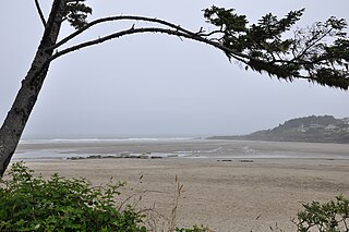
The Yachats Ocean Road State Natural Site is a state park in southern Lincoln County, Oregon, in the town of Yachats. It is administered by the Oregon Parks and Recreation Department. It is located on the Pacific Ocean coast, adjacent to the Oregon Coast Highway and the mouth of the Yachats River. The park is open for day use only, and offers scenic driving on a 1-mile (1.6 km) loop, and wildlife and surf viewing, but is backed on its landward side by low-intensity urban development.

Cape Perpetua is a large forested headland projecting into the Pacific Ocean on the central Oregon Coast in Lincoln County, Oregon. The land is managed by the United States Forest Service as part of the Siuslaw National Forest.

Hug Point State Recreation Site is a state park on the northern Oregon Coast in the U.S. state of Oregon. Administered by the Oregon Parks and Recreation Department, the park is open to the public and is fee-free. Amenities at the park, which is 5 miles (8.0 km) south of Cannon Beach along U.S. Route 101, include picnicking, fishing, and a Pacific Ocean beach.
Bullards Beach State Park is a state park in the U.S. state of Oregon, administered by the Oregon Parks and Recreation Department.
Carl G. Washburne Memorial State Park is a state park in the U.S. state of Oregon, administered by the Oregon Parks and Recreation Department. This park is in Lane County near Florence and Yachats. Very scenic wide beach, great for dogs, kids, kites. Some areas nearby are SNOWY PLOVER protected breeding areas, where dogs are banned, so be careful to keep dogs leashed if uncertain, and always in the State Park itself.

D River State Recreation Site is a state park in the U.S. state of Oregon, administered by the Oregon Parks and Recreation Department. It is a sandy beach of the Pacific Ocean within central Lincoln City along the length of the 120-foot (37 m) long D River, one of the world's shortest rivers.

Fogarty Creek State Recreation Area is a state park in the U.S. state of Oregon, administered by the Oregon Parks and Recreation Department.

Gleneden Beach State Recreation Site is a state park administered by the Oregon Parks and Recreation Department in the U.S. state of Oregon. Located along the Pacific Ocean 7 miles (11 km) south of Lincoln City, it offers public beach access, picnicking, and fishing in a setting of shore pines, sandstone bluffs, and sand. The park is fee-free.

Rocky Creek State Scenic Viewpoint is a state park in Lincoln County in northwestern Oregon, United States. Administered by the Oregon Parks and Recreation Department, the 59-acre (24 ha) park lies along a bluff between Whale Cove and Rocky Creek. The park extends south along the Otter Crest Loop Road to the Rocky Creek Bridge.

Stonefield Beach State Recreation Site is a state park in the U.S. state of Oregon, administered by the Oregon Parks and Recreation Department.

Sunset Bay State Park is a state park in the U.S. state of Oregon. Administered by the Oregon Parks and Recreation Department, it is about 0.4 miles (0.6 km) south of Cape Arago Lighthouse and 2.5 miles (4.0 km) outside the town of Charleston on Coos Bay. The park offers a crescent shaped beach, tide pools, hiking trails and a year-round campground.
Arizona Beach State Recreation Site is a 68-acre (28 ha) Oregon state park in Curry County, Oregon, in the United States. The beach is at an average elevation of 7 feet (2 m). Public recreational facilities at Arizona Beach State Recreation Site include a parking lot for beach access, observation areas for viewing marine mammals and birds and tables for picnicking. The park is open year-round.
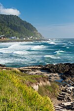 Yachats SRA, looking south towards Cape Perpetua.
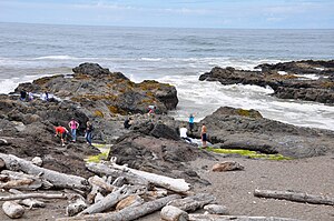
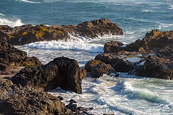 Rocky shoreline at Yachats SRA.
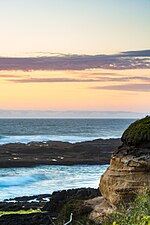 Bluff at Yachats SRA.