National Wildlife RefugeSystem (NWRS) is a system of protected areas of the United States managed by the United States Fish and Wildlife Service (FWS), an agency within the Department of the Interior. The National Wildlife Refuge System is the system of public lands and waters set aside to conserve America's fish, wildlife, and plants. Since President Theodore Roosevelt designated Florida's Pelican Island National Wildlife Refuge as the first wildlife refuge in 1903, the system has grown to over 568 national wildlife refuges and 38 wetland management districts encompassing about 856,000,000 acres (3,464,109 km2).

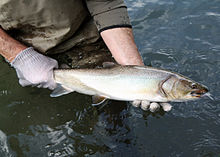
The Metolius River is a tributary of the Deschutes River in Central Oregon, United States, near the city of Sisters. The river flows north from springs near Black Butte, then turns sharply east, descending through a series of gorges before ending in the western end of the lake. The unincorporated community of Camp Sherman lies astride the southern end of the river. The name of the river comes from the Warm Springs or Sahaptin word mitula, meaning white salmon and referring to a light colored Chinook salmon and not a whitefish.
The National Survey of Fishing, Hunting, and Wildlife-Associated Recreation (Survey) has been sponsored since 1955 by the U.S. Fish and Wildlife Service and is one of the oldest and most comprehensive continuing recreation surveys. The most recent Survey (2006) found that 87.5 million U.S. residents 16 years old and older participated in wildlife-related recreation and spent $122.3 billion on their activities. During that year, 30.0 million people fished, 12.5 million hunted, and 71.1 million participated in at least one type of wildlife-watching activity such as observing, feeding, or photographing birds and other wildlife in the United States.

The Tualatin River National Wildlife Refuge is a 1,856 acres (751 ha) wetlands and lowlands sanctuary in the northwestern part of the U.S. state of Oregon. Established in 1992 and opened to the public in 2006, it is managed by the United States Fish and Wildlife Service. Located in southeastern Washington County, 15 miles (24 km) southwest of Portland, the refuge is bordered by Sherwood, Tualatin and Tigard. A newer area, extending into northern Yamhill County, is located further west near the city of Gaston surrounding the former Wapato Lake.

The Wallowa–Whitman National Forest is a United States National Forest in the U.S. states of Oregon and Idaho. Formed upon the merger of the Wallowa and Whitman national forests in 1954, it is located in the northeastern corner of the state, in Wallowa, Baker, Union, Grant, and Umatilla counties in Oregon, and includes small areas in Nez Perce and Idaho counties in Idaho. The forest is named for the Wallowa band of the Nez Perce people, who originally lived in the area, and Marcus and Narcissa Whitman, Presbyterian missionaries who settled just to the north in 1836. Forest headquarters are located in Baker City, Oregon with ranger districts in La Grande, Joseph and Baker City.

Hart Mountain National Antelope Refuge is a National Wildlife Refuge on Hart Mountain in southeastern Oregon, which protects more than 422 square miles (1,090 km2) and more than 300 species of wildlife, including pronghorn, bighorn sheep, mule deer, sage grouse, and Great Basin redband trout. The refuge, created in 1936 as a range for remnant herds of pronghorn, spans habitats ranging from high desert to shallow playa lakes, and is among the largest wildlife habitats containing no domestic livestock.

Chandler State Wayside is a state park in south-central Oregon in the United States. It is named in honor of Solomon and Hattie Chandler, who donated the land for the park. The park covers 85 acres (34 ha) of pine forest along a creek. The park provides restrooms and other basic facilities to accommodate the traveling public. Chandler State Wayside is administered by the Oregon Parks and Recreation Department.

Diamond Lake is a natural body of water in the southern part of the U.S. state of Oregon. It lies near the junction of Oregon Route 138 and Oregon Route 230 in the Umpqua National Forest in Douglas County. It is located between Mount Bailey to the west and Mount Thielsen to the east; it is just north of Crater Lake National Park.

The Wenaha–Tucannon Wilderness is a federally designated wilderness area in the Blue Mountains of northeastern Oregon, and southeastern Washington, United States. It was created by the Endangered American Wilderness Act of 1978 and encompasses 177,423 acres (71,801 ha) in the Umatilla National Forest — 66,375 acres (26,861 ha) in Oregon and 111,048 acres (44,940 ha) in Washington.
The Denman Wildlife Area is a wildlife management area near Eagle Point, Oregon, in the United States. It was named in honor of Kenneth Denman, an attorney from nearby Medford, Oregon, who lobbied for the creation of the area in 1954.

The Sauvie Island Wildlife Area is a state game management area on Sauvie Island in the U.S. state of Oregon. It contains more than 12,000 acres (4,856 ha) for mixed use including hunting, fishing, canoeing, kayaking, birdwatching and hiking. Established in 1974, it is located in both Multnomah and Columbia counties.
The Alaska Department of Fish and Game (ADF&G) is a department within the government of Alaska. ADF&G's mission is to protect, maintain, and improve the fish, game, and aquatic plant resources of the state, and manage their use and development in the best interest of the economy and the well-being of the people of the state, consistent with the sustained yield principle. ADF&G manages approximately 750 active fisheries, 26 game management units, and 32 special areas. From resource policy to public education, the department considers public involvement essential to its mission and goals. The department is committed to working with tribes in Alaska and with a diverse group of State and Federal agencies. The department works cooperatively with various universities and nongovernmental organizations in formal and informal partnership arrangements, and assists local research or baseline environmental monitoring through citizen science programs.

The Wood River is a short river in the southern region of the U.S. state of Oregon, and part of the Klamath Basin drainage. It flows 18 miles (29 km) through the Fremont-Winema National Forests, Bureau of Land Management land, and private property in southern Oregon. Its watershed consists of 220 square miles (570 km2) of conifer forest, rural pasture land, and marsh. The river provides habitat for many species of wildlife including an adfluvial (migratory) and resident populations of native Great Basin redband trout.

Little Blitzen River is a 12.5-mile (20.1 km) tributary of the Donner und Blitzen River in the U.S. state of Oregon. Little Blitzen River rises on the west flank of Steens Mountain about 20 miles (32 km) southeast of Frenchglen and about 70 miles (110 km) south of Burns in Harney County. Flowing west in a steep-walled canyon, it joins the South Fork Donner und Blitzen River at 42.6737752°N 118.7935277°W to form the Donner und Blitzen main stem, which continues north about another 40 miles (64 km) to its mouth at 43.291542°N 118.8199273°W in Malheur Lake. The Donner und Blitzen River was named by soldiers of German origin and translates as "thunder and lightning". Little Blitzen River brings to mind one of Santa Claus's reindeer.

Wapato Lake is a restored historic lake located in what became parts of Washington County and Yamhill County in the U.S. state of Oregon. The area was sometimes known as Wapato Lake Bed and Wapato Flat. The lake is located about a half mile east of Gaston at 55 metres (180 ft) elevation. The lake bed soils contain a layer of organic peat that once supported a wetland community dominated by the wapato plant, Sagittaria latifolia, particularly in the upper marsh areas. Wapato plants were reintroduced to the restored lake by tribal people from the Grand Ronde Reservation in preparation for the opening of the Wapato Lake National Wildlife Refuge in March 2023.

The Montana Department of Fish, Wildlife and Parks (MFWP) is a government agency in the executive branch state of Montana in the United States with responsibility for protecting sustainable fish, wildlife, and state-owned park resources in Montana for the purpose of providing recreational activities. The agency engages in law enforcement activities to enforce laws and regulations regarding fish, wildlife, and state parks, and encourages safe recreational use of these resources.
The Interstate Wildlife Violator Compact (IWVC) is a United States interstate compact to provide reciprocal sharing of information regarding sportsman fishing, hunting, and trapping violations and allows for recognition of suspension or revocation of hunting, fishing, and trapping licenses and permits in other member states resulting from violations concerning hunting, fishing and trapping laws in order to prevent poaching across state lines. All 50 US states are members of the compact.

A fishing license (US), fishing licence (UK), or fishing permit is an administrative or legal mechanism employed by state and local governments to regulate fishing activities within their administrative areas. Licensing is one type of fisheries management commonly used in Western countries, and may be required for either commercial or recreational fishing.

Spring Creek Hatchery State Park is a public recreation area lying within the Columbia River Gorge National Scenic Area on Route 14 in Skamania County, Washington. The state park occupies ten acres (4.0 ha) directly across the Columbia River from Hood River, Oregon. It offers excellent windsurfing and kiteboarding opportunities, as well as picknicking, fishing, and wildlife viewing. The park lies next to the Spring Creek National Fish Hatchery, which offers interpretive programs and self-guided tours.

Salem Ditch is an artificial canal in Marion County, Oregon, United States. It drains into Mill Creek.