Sherman County, Oregon

Last updated

Sherman County
Sherman county oregon courthouse.jpg
Sherman County Courthouse in Moro
Map of Oregon highlighting Sherman County.svg
Location within the U.S. state of Oregon
Oregon in United States.svg
Oregon's location within the U.S.
Coordinates: 45°25′N120°41′W / 45.41°N 120.69°W / 45.41; -120.69
CountryFlag of the United States.svg United States
StateFlag of Oregon.svg  Oregon
FoundedFebruary 25, 1889
Named for William T. Sherman
Seat Moro
Largest city Wasco
Area
  Total831 sq mi (2,150 km2)
  Land824 sq mi (2,130 km2)
  Water7.5 sq mi (19 km2)  0.9%
Population
 (2020)
  Total1,870
  Estimate 
(2023)
1,951 Increase2.svg
  Density2.1/sq mi (0.8/km2)
Time zone UTC−8 (Pacific)
  Summer (DST) UTC−7 (PDT)
Congressional district 2nd
Website co.sherman.or.us

Sherman County is one of the 36 counties in the U.S. state of Oregon. As of the 2020 census, the population was 1,870, [1] making it the second-least populous county in Oregon after nearby Wheeler. The county seat is Moro, [2] and the largest city is Wasco. The county is named for William Tecumseh Sherman, a Union general in the American Civil War.

Contents

History

Old grain elevator in Kent Old Grain Elevator (Sherman County, Oregon scenic images) (sheD0049).jpg
Old grain elevator in Kent

As the pioneers felt crowded in the new settlements of western Oregon, they turned east to the Columbia Plateau for new opportunities. The county's first white settler was William Graham, who located at the mouth of the Deschutes River in 1858. [3] Homesteaders, eager for land, arrived in the 1880s by steamboat, stagecoach and wagon. Soon farmers received government patents.

As the population grew, so did the sentiment for independence from Wasco County. [3] Sherman County was created on February 25, 1889, out of the northeast corner of Wasco County. The county's borders have been changed only once, in 1891, when the Legislative Assembly moved the county line 18 miles (29 km) farther south into Wasco County.

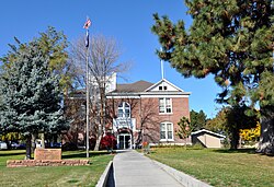
The town of Wasco was designated the county seat by the Legislative Assembly although this designation was contested between Wasco and Moro. Following the addition of a portion of Wasco County, Moro became the eventual winner.

Geography

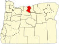
Sherman County is located in the central northern part of Oregon, east of the Cascade Range. It lies between the John Day River to the east and the Deschutes River to the west, which defines the borders of the county. On the northern border of the county is the Columbia River. Sherman County is mostly flat, being part of the Columbia Plateau; its highest point is at an unknown location at 3,004 feet (916m). [4]

According to the United States Census Bureau, the county has a total area of 831 square miles (2,150 km2), of which 824 square miles (2,130 km2) is land and 7.5 square miles (19 km2) (0.9%) is water. [5]

Adjacent counties

Map of Sherman County Sherman County.svg
Map of Sherman County

Demographics

Historical population
CensusPop.Note
1890 1,792
1900 3,47794.0%
1910 4,24222.0%
1920 3,826−9.8%
1930 2,978−22.2%
1940 2,321−22.1%
1950 2,271−2.2%
1960 2,4467.7%
1970 2,139−12.6%
1980 2,1721.5%
1990 1,918−11.7%
2000 1,9340.8%
2010 1,765−8.7%
2020 1,8705.9%
2023 (est.)1,951 [6] 4.3%
U.S. Decennial Census [7]
1790–1960 [8] 1900–1990 [9]
1990–2000 [10] 2010–2020 [1]
From 2000 to 2007, Sherman County lost 4.1% of its population, the second-lowest growth rate in the state. Oregon Population Growth by County.png
From 2000 to 2007, Sherman County lost 4.1% of its population, the second-lowest growth rate in the state.

2010 census

As of the 2010 census, there were 1,765 people, 777 households, and 492 families living in the county. [11] The population density was 2.1 inhabitants per square mile (0.81/km2). There were 918 housing units at an average density of 1.1 per square mile (0.42/km2). [12] The racial makeup of the county was 93.4% white, 1.6% American Indian, 0.2% black or African American, 0.2% Asian, 0.1% Pacific islander, 2.7% from other races, and 1.8% from two or more races. Those of Hispanic or Latino origin made up 5.6% of the population. [11] In terms of ancestry, 22.6% were German, 16.5% were English, 13.0% were Irish, and 4.9% were American. [13]

Of the 777 households, 23.0% had children under the age of 18 living with them, 51.2% were married couples living together, 7.5% had a female householder with no husband present, 36.7% were non-families, and 30.5% of all households were made up of individuals. The average household size was 2.27 and the average family size was 2.84. The median age was 48.2 years. [11]

The median income for a household in the county was $41,354 and the median income for a family was $52,361. Males had a median income of $42,768 versus $32,386 for females. The per capita income for the county was $21,688. About 13.9% of families and 20.0% of the population were below the poverty line, including 38.2% of those under age 18 and 9.9% of those age 65 or over. [14]

2000 census

As of the 2000 census, there were 1,934 people, 797 households, and 545 families living in the county. The population density was 2 (2,3) people per square mile (1/km2). There were 935 housing units at an average density of 1 per square mile (0/km2). The racial makeup of the county was 93.59% White, 0.21% Black or African American, 1.40% Native American, 0.47% Asian, 2.79% from other races, and 1.55% from two or more races. 4.86% of the population were Hispanic or Latino of any race. 20.5% were of German, 17.3% American, 11.7% English, 8.7% Irish and 5.3% Norwegian ancestry.

There were 797 households, out of which 29.90% had children under the age of 18 living with them, 58.50% were married couples living together, 6.50% had a female householder with no husband present, and 31.50% were non-families. 28.70% of all households were made up of individuals, and 14.10% had someone living alone who was 65 years of age or older. The average household size was 2.43 and the average family size was 2.97.

In the county, the population was spread out, with 26.40% under the age of 18, 5.80% from 18 to 24, 23.40% from 25 to 44, 26.10% from 45 to 64, and 18.30% who were 65 years of age or older. The median age was 42 years. For every 100 females there were 102.90 males. For every 100 females age 18 and over, there were 105.00 males.

The median income for a household in the county was $35,142, and the median income for a family was $42,563. Males had a median income of $31,207 versus $21,579 for females. The per capita income for the county was $17,448. About 12.30% of families and 14.60% of the population were below the poverty line, including 20.20% of those under age 18 and 7.70% of those age 65 or over.

Government and infrastructure

The Northern Oregon Regional Corrections Facility (Norcor), a short-term jail, serves Sherman, Gilliam, Hood River, and Wasco counties. [15] Although Sherman County is located in Central Oregon, its politics are more-aligned with the eastern parts of the state with most of its voters being affiliated with the Republican Party. No Democrat has carried this county in a presidential election since Lyndon Johnson in 1964. The last time a Democrat had won over 400 votes here was in 1996 with Bill Clinton, who lost the county to Bob Dole by a margin of 32 votes.

United States presidential election results for Sherman County, Oregon [16]
Year Republican Democratic Third party
No.%No.%No.%
2020 92176.24%26021.52%272.24%
2016 73271.98%20219.86%838.16%
2012 67866.08%31931.09%292.83%
2008 63460.55%38536.77%282.67%
2004 69462.86%39035.33%201.81%
2000 67963.94%32630.70%575.37%
1996 47644.61%44441.61%14713.78%
1992 42437.99%36232.44%33029.57%
1988 55554.63%43542.81%262.56%
1984 82867.48%39832.44%10.08%
1980 67757.86%38933.25%1048.89%
1976 56751.13%49144.27%514.60%
1972 67764.91%33031.64%363.45%
1968 64659.32%38435.26%595.42%
1964 49436.51%85963.49%00.00%
1960 65956.57%50643.43%00.00%
1956 67161.50%42038.50%00.00%
1952 74767.48%35532.07%50.45%
1948 53253.20%45445.40%141.40%
1944 47547.69%51852.01%30.30%
1940 57546.07%67053.69%30.24%
1936 33727.78%82367.85%534.37%
1932 42338.04%66559.80%242.16%
1928 75966.35%37532.78%100.87%
1924 75655.92%36727.14%22916.94%
1920 89365.57%42331.06%463.38%
1916 71746.86%74748.82%664.31%
1912 24434.86%23233.14%22432.00%
1908 43758.27%25233.60%618.13%
1904 70171.10%16316.53%12212.37%

Economy

Sherman County is predominantly an agricultural county, its economy receiving some aid from ranching and tourism. Its farms primarily produce wheat and barley. It is also home to the Biglow Canyon Wind Farm, the largest project of its kind in Oregon. [17]

Communities

Cities

Census-designated place

Other unincorporated communities

See also

Footnotes

  1. 1 2 "State & County QuickFacts". United States Census Bureau. Retrieved May 20, 2023.
  2. "Find a County". National Association of Counties. Retrieved June 7, 2011.
  3. 1 2 In the beginning, Sherman County Historical Society and Museum
  4. Oregonian/OregonLive, Karly Imus | The (February 15, 2017). "What's the highest point in each of Oregon's 36 counties?". oregonlive. Retrieved March 6, 2023.
  5. "2010 Census Gazetteer Files". United States Census Bureau. August 22, 2012. Retrieved February 28, 2015.
  6. "Annual Estimates of the Resident Population for Counties: April 1, 2020 to July 1, 2023". United States Census Bureau. Retrieved March 24, 2024.
  7. "U.S. Decennial Census". United States Census Bureau. Retrieved February 28, 2015.
  8. "Historical Census Browser". University of Virginia Library. Retrieved February 28, 2015.
  9. Forstall, Richard L., ed. (March 27, 1995). "Population of Counties by Decennial Census: 1900 to 1990". United States Census Bureau. Retrieved February 28, 2015.
  10. "Census 2000 PHC-T-4. Ranking Tables for Counties: 1990 and 2000" (PDF). United States Census Bureau. April 2, 2001. Archived from the original (PDF) on February 26, 2015. Retrieved February 28, 2015.
  11. 1 2 3 "DP-1 Profile of General Population and Housing Characteristics: 2010 Demographic Profile Data". United States Census Bureau. Archived from the original on February 13, 2020. Retrieved February 23, 2016.
  12. "Population, Housing Units, Area, and Density: 2010 - County". United States Census Bureau. Archived from the original on February 13, 2020. Retrieved February 23, 2016.
  13. "DP02 SELECTED SOCIAL CHARACTERISTICS IN THE UNITED STATES – 2006-2010 American Community Survey 5-Year Estimates". United States Census Bureau. Archived from the original on February 13, 2020. Retrieved February 23, 2016.
  14. "DP03 SELECTED ECONOMIC CHARACTERISTICS – 2006-2010 American Community Survey 5-Year Estimates". United States Census Bureau. Archived from the original on February 13, 2020. Retrieved February 23, 2016.
  15. "Norcor Home Archived November 24, 2011, at the Wayback Machine ." Northern Oregon Regional Corrections Facility. Retrieved on November 22, 2011.
  16. Leip, David. "Dave Leip's Atlas of U.S. Presidential Elections". uselectionatlas.org. Retrieved April 11, 2018.
  17. Hill, Gail Kinsey. Wind farm in gorge may blow others away. The Oregonian . August 1, 2005.

Further reading

Newspapers

Moro Bulletin.

45°25′N120°41′W / 45.41°N 120.69°W / 45.41; -120.69

Related Research Articles

<span class="mw-page-title-main">Klickitat County, Washington</span> County in Washington, United States

Klickitat County is a county located in the U.S. state of Washington. As of the 2020 census, the population was 22,735. The county seat and largest city is Goldendale. The county is named after the Klickitat tribe.

<span class="mw-page-title-main">Wheeler County, Oregon</span> County in Oregon, United States

Wheeler County is a county in the U.S. state of Oregon. As of the 2020 census, the population was 1,451, making it Oregon's least populous county. It is named in honor of Henry H. Wheeler. an early settler who owned a farm near Mitchell. The county seat is Fossil, and Wheeler County is known for having Oregon's largest deposit of fossils.

<span class="mw-page-title-main">Wasco County, Oregon</span> County in Oregon, United States

Wasco County is one of the 36 counties in the U.S. state of Oregon. As of the 2020 census, the population was 25,213. Its county seat is The Dalles. The county is named for a local tribe of Native Americans, the Wasco, a Chinook tribe who live on the south side of the Columbia River. It is near the Washington state line. Wasco County comprises The Dalles Micropolitan Statistical Area.

<span class="mw-page-title-main">Union County, Oregon</span> County in Oregon, United States

Union County is one of the 36 counties in the U.S. state of Oregon, and one of the 8 counties of eastern Oregon. As of the 2020 census, the population was 26,196. The county comprises the La Grande micropolitan statistical area and the county seat is La Grande.

<span class="mw-page-title-main">Morrow County, Oregon</span> County in Oregon, United States

Morrow County is one of the 36 counties in the U.S. state of Oregon. As of the 2020 census, the population was 12,186. The county seat is Heppner. The county is named for one of its first settlers, Jackson L. Morrow, who was a member of the state legislature when the county was created. Half of the Umatilla Chemical Depot, which includes the Umatilla Chemical Agent Disposal Facility, and the Naval Weapons Systems Training Facility Boardman are located within the county. Morrow County is part of the Pendleton-Hermiston, OR, Micropolitan Statistical Area. It is located on the south side of the Columbia River and is included in the eight-county definition of Eastern Oregon.

<span class="mw-page-title-main">Jefferson County, Oregon</span> County in Oregon, United States

Jefferson County is one of the 36 counties in the U.S. state of Oregon. At the 2020 census, the population was 24,502. The county seat is Madras. The county is named after Mount Jefferson, the second tallest mountain in Oregon.

<span class="mw-page-title-main">Hood River County, Oregon</span> County in Oregon, United States

Hood River County is one of the 36 counties in the U.S. state of Oregon. As of the 2020 census, the population was 23,977. The county seat is Hood River. The county was established in 1908 and is named for the Hood River, a tributary of the Columbia River. Hood River County comprises the Hood River, OR Micropolitan Statistical Area. The Hood River Valley produces apples, pears, and cherries. Situated between Mount Hood and the Columbia River in the middle of the Columbia River Gorge, Hood River County is a popular destination for outdoor enthusiasts, such as windsurfers, mountain-bikers, skiers, hikers, kayakers, and many more.

<span class="mw-page-title-main">Gilliam County, Oregon</span> County in Oregon, United States

Gilliam County is one of the 36 counties in the U.S. state of Oregon. As of the 2020 census, the population was 1,995, making it the third-least populous county in Oregon. The county seat is Condon. The county was established in 1885 and is named for Cornelius Gilliam, a colonel who commanded the forces of the provisional government of Oregon after the Whitman Massacre.

<span class="mw-page-title-main">Crook County, Oregon</span> County in Oregon, United States

Crook County is one of the 36 counties in the U.S. state of Oregon. As of the 2020 census, the population was 24,738. The county seat is Prineville. The county is named after George Crook, a U.S. Army officer who served in the American Civil War and various Indian Wars.

<span class="mw-page-title-main">Condon, Oregon</span> City in Oregon, United States

Condon is a city in, and the seat of, Gilliam County, in the U.S. state of Oregon. The population was 682 at the 2010 census. The city, with an historic main street along Oregon Route 19, is a farming and ranching community. The John Day River/Cottonwood Canyon State Park, the ghost town of Lonerock and the John Day Fossil Beds are all a short drive from Historic Condon.

<span class="mw-page-title-main">Bonanza, Oregon</span> Town in Oregon, United States

Bonanza is a town in Klamath County, Oregon, United States, near Klamath Falls. The population was 415 at the 2010 census.

<span class="mw-page-title-main">Merrill, Oregon</span> City in Oregon, United States

Merrill is a city in Klamath County, Oregon, United States. The population was 844 at the 2010 census.

<span class="mw-page-title-main">Heppner, Oregon</span> City in Oregon, United States

Heppner is a city in, and the county seat of, Morrow County, Oregon, United States. As of 2010, the population was 1,291. Heppner is part of the Pendleton-Hermiston Micropolitan Area. Heppner is named after Henry Heppner, a prominent Jewish-American businessman.

<span class="mw-page-title-main">Moro, Oregon</span> City in Oregon, United States

Moro is a city in Sherman County, Oregon, United States. The population was 324 at the 2010 census. It is the county seat of Sherman County. It’s currently the least-populous county seat in Oregon. Moro was incorporated on February 17, 1899, by the Oregon Legislative Assembly. It was named for Moro, Illinois.

<span class="mw-page-title-main">Wasco, Oregon</span> City in Oregon, United States

Wasco is a city in Sherman County, Oregon, United States. The population was 410 at the 2010 census.

<span class="mw-page-title-main">Chenoweth, Oregon</span> Community in Oregon, United States

Chenoweth is an unincorporated community in Wasco County, Oregon, United States. Locally the alternative spelling of Chenowith is used, such as for the 'Chenowith Elementary School'. For statistical purposes, the United States Census Bureau has defined Chenoweth as a census-designated place (CDP). The census definition of the area may not precisely correspond to local understanding of the area with the same name. The population of the CDP was 3,412 at the 2000 census.

<span class="mw-page-title-main">Pine Grove, Wasco County, Oregon</span> Unincorporated community in the state of Oregon, United States

Pine Grove is a census-designated place (CDP) and unincorporated community in Wasco County, Oregon, United States. The population was 162 at the 2000 census.

<span class="mw-page-title-main">Pine Hollow, Oregon</span> Unincorporated community in the state of Oregon, United States

Pine Hollow is a census-designated place (CDP) and unincorporated community in Wasco County, Oregon, United States. It surrounds Pine Hollow Reservoir. The CDP population was 424 at the 2000 census.

<span class="mw-page-title-main">Tygh Valley, Oregon</span> Unincorporated community in the state of Oregon, United States

Tygh Valley is a census-designated place (CDP) and unincorporated community in Wasco County, Oregon, United States. The population was 224 at the 2000 census.

<span class="mw-page-title-main">Wamic, Oregon</span> Unincorporated community in the state of Oregon, United States

Wamic is a census-designated place (CDP) and unincorporated community in Wasco County, Oregon, United States. Wamic was named for the Womack family, which settled the area. A post office was established at Wamic in 1884 and it closed in 1958. The population was 36 at the 2000 census.