
Prospect is an unincorporated community and census-designated place (CDP) in Jackson County, in the U.S. state of Oregon. It lies along Oregon Route 62 on the Rogue River, in the Rogue River – Siskiyou National Forest. As of the 2010 census it had a population of 455.
Friend is an unincorporated community in Wasco County in the U.S. state of Oregon. Considered a ghost town, little remains of the community except the Friend Store, a one-room schoolhouse, and a cemetery.

Lake Creek is an unincorporated community about 20 miles (32 km) east of Medford, in Jackson County, Oregon, United States. The community takes its name from Lake Creek, an important local stream.

Copperfield is a former town in Baker County, in the U.S. state of Oregon. It is on the west bank of the Snake River and the north bank of Pine Creek, downstream of a feature of the Snake River known as The Oxbow. Copperfield Park, managed by Idaho Power, occupies the former town site. The Geographic Names Information System also lists Copperfield as a variant name for Oxbow, Oregon.

Blachly is an unincorporated community in Lane County, Oregon, United States, on Oregon Route 36 in the Coast Range. Blachly lies along Lake Creek, about 3 miles (5 km) from Triangle Lake.

Wimer is an unincorporated community and census-designated place (CDP) in Jackson County, Oregon, United States. As of the 2010 census it had a population of 678. Wimer lies along Evans Creek north of the city of Rogue River.

Kent is an unincorporated community in Sherman County, Oregon, United States. Kent has a post office with a ZIP code 97033. Kent lies at the intersection of U.S. Route 97 and Dobie Point Road, between Grass Valley to the north and Shaniko to the south.
Wingville is an unincorporated community in Baker County, Oregon, United States. Wingville lies at the intersection of Wingville Lane and Old Wingville Road northwest of Baker City and northeast of Pocahontas.
Hereford is an unincorporated community in Baker County, in the U.S. state of Oregon. Hereford lies along the Burnt River southwest of Baker. It is on Oregon Route 245 northeast of its intersection with U.S. Route 26 in Unity. Hereford is 3,671 feet (1,119 m) above sea level.

New Princeton is an unincorporated community in Harney County, in the U.S. state of Oregon. It is along Oregon Route 78 between Burns and Burns Junction at an elevation of 4,111 feet (1,253 m) above sea level. The South Fork Malheur River begins near Round Mountain, southeast of New Princeton.
Fairview is an unincorporated community in Coos County, Oregon, United States. Fairview is along the North Fork Coquille River about 6 miles (10 km) northeast of Coquille.
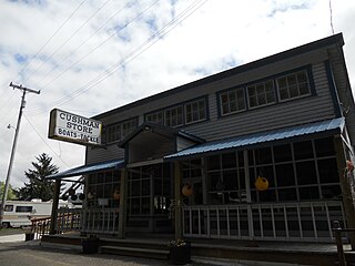
Cushman is an unincorporated community in Lane County, Oregon, United States. It is located on the north bank of the Siuslaw River on Oregon Route 126, between Tiernan and Florence.
Gravelford is an unincorporated community in Coos County, Oregon, United States. It is about 8 miles (13 km) northeast of Myrtle Point, at the confluence of the North Fork Coquille River and the East Fork Coquille River.
Pawn was a historic unincorporated community in Lane County in the U.S. state of Oregon. It lay at the headwaters of the North Fork Siuslaw River, where Sam Creek and West Branch join to form the river in the Siuslaw National Forest of the Central Oregon Coast Range. Downstream is the unincorporated community of Minerva, and further downstream, near the mouth of the river on the Siuslaw River is the city of Florence.
Suntex is the name of an unincorporated community in Harney County, in the U.S. state of Oregon. It was established with the placement of a post office in the valley of Silver Creek west of Burns and north of U.S. Route 20.
Harney is an unincorporated community in Harney County, in the U.S. state of Oregon. It lies north of U.S. Route 20 between Burns and Buchanan near the site of historic Fort Harney. The community, county, and nearby geographic features such as Harney Lake are named for William S. Harney, a military officer popular in the Pacific Northwest in the mid-19th century.
Penn is an unincorporated community and former railway station in Lane County, in the U.S. state of Oregon. It was named for the Penn Timber Company, which operated in the vicinity.
Bagnell Ferry is an unincorporated community in Curry County, Oregon, United States. It lies along the north bank of the Rogue River about 5 miles (8 km) upstream of Gold Beach.
Steamboat is an unincorporated community in Jackson County, Oregon, United States. It lies along Carberry Creek, a tributary of the Applegate River, in the Rogue River – Siskiyou National Forest. Slightly west of Steamboat is the Jackson–Josephine county border, and the border with California is about 6 miles (10 km) to the south.
Dardanelles is an unincorporated community in Jackson County, Oregon, United States. It lies opposite the city of Gold Hill on the south side of the Rogue River. Interstate 5 and Oregon Route 99 pass by Gold Hill and Dardanelles.


