Oregon Geographic Names is a compilation of the origin and meaning of place names in the U.S. state of Oregon, published by the Oregon Historical Society. The book was originally published in 1928. It was compiled and edited by Lewis A. McArthur. As of 2011, the book is in its seventh edition, which was compiled and edited by Lewis L. McArthur.

Twin Rocks is an unincorporated community in Tillamook County, Oregon, United States, on the Oregon Coast. Twin Rocks, founded as a summer resort community, was named for two offshore rocks, 100 feet (30 m) high, in the Pacific Ocean. Twin Rocks post office was established in 1914, with William E. Dunsmoor as the first postmaster. The post office closed in 1954.
Woods is an unincorporated community in Tillamook County, Oregon, United States. Woods lies at the intersection of Brooten Road, Resort Drive, and Old Woods Road, along the Nestucca River just north of Pacific City and west of U.S. Route 101.
Hereford is an unincorporated community in Baker County, in the U.S. state of Oregon. Hereford lies along the Burnt River southwest of Baker. It is on Oregon Route 245 northeast of its intersection with U.S. Route 26 in Unity. Hereford is 3,671 feet (1,119 m) above sea level.

New Princeton is an unincorporated community in Harney County, in the U.S. state of Oregon. It is along Oregon Route 78 between Burns and Burns Junction at an elevation of 4,111 feet (1,253 m) above sea level. The South Fork Malheur River begins near Round Mountain, southeast of New Princeton.
Libby, previously known as Easport, is an unincorporated community on Coalbank Slough in Coos County, Oregon, United States. It was named for a Native American woman. Its post office was established on June 11, 1890, and operated for just two years. Enoch Gore was postmaster.
Melville is an unincorporated community in Clatsop County, Oregon, United States, on the Lewis and Clark River. Its post office was established in February 1891, with Wilthea S. Ingalls postmaster. The post office closed in November 1922.
Nye is an unincorporated community in Umatilla County, Oregon, United States. It is approximately 8 miles (13 km) west of Pilot Rock, at the junction of U.S. Route 395 and Oregon Route 74.
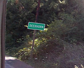
Deerhorn is an unincorporated community in Lane County, Oregon, United States. It is about 4 miles (6 km) west of Leaburg on Oregon Route 126 in the McKenzie River valley.
Pleasant Valley is an unincorporated community in Tillamook County, Oregon, United States. It is located about seven miles south of Tillamook, on U.S. Route 101.
Beulah is an unincorporated community in Malheur County, in the U.S. state of Oregon. It is along the North Fork Malheur River near Beulah Reservoir, 15 miles (24 km) north of Juntura.
Hutchinson is an unincorporated community in Baker County, Oregon, United States. It is about 5 miles (8 km) northwest of Haines, west of U.S. Route 30.
Encina is an unincorporated community in Baker County, Oregon, United States. Encina is about 10 miles (16 km) southeast of Baker City near exit 313 of U.S. Route 30/Interstate 84.
Tenmile is an unincorporated community in Coos County, Oregon, United States. It is about 8 miles (13 km) south of Winchester Bay and one mile west of Lakeside, on U.S. Route 101 next to Tenmile Creek and the Oregon Dunes. Tenmile Lake was named for Tenmile Creek, which was said to be ten miles south of Winchester Bay.
Faubion is an unincorporated community in Clackamas County, Oregon, United States. It is located about 2 miles northwest of Rhododendron, in the Mount Hood Corridor on a loop road off U.S. Route 26 near the Zigzag River.

De Moss Springs is an unincorporated community in Sherman County, in the U.S. state of Oregon. It is about 3 miles (5 km) northeast of Moro along U.S. Route 97.
Erskine is an unincorporated community in Sherman County, in the U.S. state of Oregon. It lies between Moro and Grass Valley along Erskine Road, west of U.S. Route 97.
Rye Valley is an unincorporated community in Baker County, in the U.S. state of Oregon. It lies along Dixie Creek, a tributary of the Burnt River, about 30 miles (48 km) southeast of Baker City. It is slightly west of Interstate 84 near Weatherby and Dixie.

Cove Orchard is an unincorporated community in Yamhill County, in the U.S. state of Oregon. It is along Oregon Route 47 between Yamhill and Gaston in the northern part of the county.
Pelican City is an unincorporated community in Klamath County in the U.S. state of Oregon. It lies along U.S. Route 97 just north of the city of Klamath Falls near the south end of Upper Klamath Lake and the upstream end of the Link River.


