Balonne River

Last updated

Balonne
StGeorgeBalonneRiver.JPG
The Balonne River at St George, Queensland
Australia Queensland relief location map.jpg
Red pog.svg
Location of where the Balonne River branches to form the Bokhara and Narran rivers in Queensland
Etymology Mandandanji: water or running stream. [1]
Location
Country Australia
State Queensland
Region South West Queensland
City St George
Physical characteristics
Source Condamine River
  locationat Surat
  elevation274 m (899 ft)
Mouth
  location
near Dirranbandi
  coordinates
28°43′27″S148°03′6″E / 28.72417°S 148.05167°E / -28.72417; 148.05167 Coordinates: 28°43′27″S148°03′6″E / 28.72417°S 148.05167°E / -28.72417; 148.05167
  elevation
171 m (561 ft)
Length479 km (298 mi)
Discharge 
  average65 m3/s (2,300 cu ft/s)
Basin features
River system Darling River, Murray-Darling basin
Tributaries 
  right Maranoa River
Reservoir Lake Kajarabie
[2]

The Balonne River, part of the Murray-Darling Basin system, is a short yet significant part of the inland river group of South West Queensland, Australia.

Contents

Course and features

The river is a continuation of the Condamine River. After flowing through Surat the river flows south south-westerly down through the E.J. Beardmore Dam (Lake Kajarabie). [2] Passing through St George it continues in the same south-west direction, until about 20 kilometres (12 mi) north of Dirranbandi, where it branches, with the western branch then being called the Culgoa River. The eastern branch continues on as the Balonne River through Dirranbandi. Shortly after flowing through Dirranbandi, the Balonne River again branches into the Bokhara River on the west side (the right side when going down stream) and the Narran River on the eastern (left) side. [3] The Narran River flows into Narran Wetlands. The Bokhara River joins with the Barwon River west of Brewarrina. The confluence of the Culgoa River (a western branch of the Balonne River) and the Barwon River (which includes a former central branch of the Balonne) forms the start of the Darling River.

The Balonne-Condamine catchment area is 136,014 square kilometres (52,515 sq mi), of which an area of 603 square kilometres (233 sq mi) is composed of riverine wetlands and 559 square kilometres (216 sq mi) is estuarine wetlands. [4]

The five longest tributaries of the Balonne River are the Condamine River, the Maranoa River, Dogwood Creek, Yuleba Creek and Tartulla Creek. At St George, the river is crossed by the Andrew Nixon Bridge which carries the Balonne Highway. [5]

Water storage

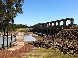
E.J. Beardmore Dam was formed by the construction of a weir in 1972 at the junction of the Maranoa and Balonne Rivers. [6] When the dam is full the water backs up for 70 kilometres (43 mi) along the Balonne. Downstream from Beardmore Dam is the Jack Taylor Weir, which was built in 1953. [6] On the Balonne tributary, Dogwood Creek there is another weir, the Gill Weir, which can hold 1,050 megalitres (230×10^6 imp gal; 280×10^6 US gal).

History

Major Thomas Mitchell crossed the Balonne River on St George's Day, 23 April 1846. Mitchell named the river after the Mandandanji word for water or running stream, balun or balonn or balonne. [1]

See also

Related Research Articles

Darling River Major river in Australia

The Darling River is the third-longest river in Australia, measuring 1,472 kilometres (915 mi) from its source in northern New South Wales to its confluence with the Murray River at Wentworth, New South Wales. Including its longest contiguous tributaries it is 2,844 km (1,767 mi) long, making it the longest river system in Australia. The Darling River is the outback's most famous waterway.

Condamine River River in Queensland, Australia

The Condamine River, part of the Balonne catchment that is part of the Murray-Darling Basin, drains the northern portion of the Darling Downs, an area of sub-coastal southern Queensland, Australia. The river is approximately 500 kilometers (310 mi) long and rises on Mount Superbus, South East Queensland's highest peak, on the western slopes of the Great Dividing Range, approximately 100 kilometres (62 mi) from the east coast of Queensland, and then flows north west across the Darling Downs, then west. The Condamine River is a tributary of the Darling River.

The Culgoa River is a river that is part of the Darling catchment within the Murray–Darling basin and is located in South West Queensland.

Barwon River (New South Wales)

Barwon River, a perennial river that is part of the Murray–Darling basin, is located in the north-west slopes and Orana regions of New South Wales, Australia.

Hebel, Queensland Town in Queensland, Australia

Hebel is a rural town and locality in the Shire of Balonne, Queensland, Australia. It is on the border of Queensland and New South Wales. In the 2016 census, Hebel had a population of 67 people.

Walgett, New South Wales Town in New South Wales, Australia

Walgett is a town in northern New South Wales, Australia, and the seat of Walgett Shire. It is near the junctions of the Barwon and Namoi Rivers and the Kamilaroi and Castlereagh Highways. In 2016, Walgett had a population of 2,145.

Dirranbandi is a rural town and locality in the Shire of Balonne, Queensland, Australia. The locality is on the border of Queensland with New South Wales. In the 2016 census, Dirranbandi had a population of 640 people.

Warrego River River in Australia

The Warrego River is an intermittent river that is part of the Darling catchment within the Murray–Darling basin, which is located in South West Queensland and in the Orana region of New South Wales, Australia. The Warrego River is the northernmost tributary of the Darling River.

Boomi, New South Wales Town in New South Wales, Australia

Boomi is a town in north western New South Wales, Australia. The town is in the Moree Plains Shire local government area, 728 kilometres (452 mi) north west of the state capital, Sydney, on the border on the New South Wales side of the MacIntyre River. Boomi is west of the Queensland town of Goondiwindi and north of Moree in New South Wales. At the 2016 census, Boomi and the surrounding farming area had a population of approximately 200.

Shire of Balonne Local government area in Queensland, Australia

The Shire of Balonne is a local government area in South West Queensland, Australia, over 500 kilometres (310 mi) from the state capital, Brisbane. It covers an area of 31,104 square kilometres (12,009.3 sq mi), and has existed as a local government entity since 1879. It is headquartered in its main town, St George.

Narran County Cadastral in New South Wales, Australia

Narran County is one of the 141 Cadastral divisions of New South Wales. It is bounded by the Culgoa River on the west, the Narran River in the east, the Queensland border in the north, and the Barwon River in the south. It includes Goodooga and the area to the north of Brewarrina.

Goodooga, New South Wales Town in New South Wales, Australia

Goodooga is a town in the Australian state of New South Wales in Brewarrina Shire on the eastern bank of the Bokhara River. It is near Brewarrina and Lightning Ridge, its closest neighbour. The town lies 20 kilometres (12 mi) south of the Queensland border, and the border town of Hebel.

E.J. Beardmore Dam Dam in South West Queensland

The E.J. Beardmore Dam, an earth-fill embankment dam with a concrete gravity wall across the Balonne River, is located in South West Queensland, Australia. The main purpose of the dam is for irrigation. The resultant reservoir is called Lake Kajarabie.

Maranoa River

The Maranoa River, part of the Murray-Darling basin, is a river situated in South West Queensland, Australia.

Moonie River River in Queensland and New South Wales, Australia

The Moonie River is a river in Shire of Balonne, Queensland and Walgett Shire, New South Wales, both in Australia. It is a perennial river of the Barwon catchment within the Murray–Darling basin.

The Bokhara River, a watercourse that is part of the Barwon catchment within the Murray–Darling basin, is located in the South Downs region of Queensland, flowing downstream into the north–western slopes of New South Wales, Australia. It flows through the lower Balonne floodplain.

Narran River River in Queensland and New South Wales Australia

Narran River, a watercourse of the Barwon catchment within the Murray–Darling basin, is located in the Southern Downs district of Queensland and Orana district of New South Wales, Australia.

Narran Wetlands Protected area in New South Wales, Australia

The Narran Wetlands, also known as the Narran Lakes, contained within the Narran Lake Nature Reserve, comprise a series of protected ephemeral lakes and swamps fed by the Narran River in the north-west of New South Wales, Australia. The 26,480-hectare (65,400-acre) reserve is located approximately 50 kilometres (31 mi) east of Brewarrina.

South West Queensland Region in Queensland, Australia

South West Queensland is a remote region in the Australian state of Queensland which covers 319,808 km2 (123,479 sq mi). The region lies to the south of Central West Queensland and west of the Darling Downs and includes the Maranoa district and parts of the Channel Country. The area is noted for its cattle grazing, cotton farming, opal mining and oil and gas deposits.

Dogwood Creek (Queensland)

Dogwood Creek is a creek in the Maranoa Region, Queensland, Australia.

References

  1. 1 2 "Balonne River River (entry 1434)". Queensland Place Names. Queensland Government . Retrieved 23 June 2015.
  2. 1 2 "Map of Balonne River, QLD". Bonzle Digital Atlas of Australia. Retrieved 31 January 2009.
  3. "Chisholm, Alec H.". The Australian Encyclopaedia. Vol. 1. Sydney: Halstead Press. 1963. p. 406. Balonne River.
  4. "Balonne-Condamine drainage basin drainage basin". WetlandInfo. Queensland Government . Retrieved 23 June 2015.
  5. "Andrew Nixon Bridge". Balonne Shire Council. Archived from the original on 19 February 2011. Retrieved 8 February 2011.
  6. 1 2 Harrison, Rod; Ernie James; Chris Sully; Bill Classon; Joy Eckermann (2008). Queensland Dams. Bayswater, Victoria: Australian Fishing Network. p. 155. ISBN   978-1-86513-134-4.