
The Australian Capital Territory (ACT), known as the Federal Capital Territory (FCT) until 1938, is a federal territory of Australia containing the Australian capital city of Canberra and some surrounding townships. It is located in the south-east of the country and is an enclave within the state of New South Wales. Founded after Federation as the seat of government for the new nation, all important institutions of the Australian Government are headquartered in the territory.

Namadgi National Park is a protected area in the south-west of the Australian Capital Territory, bordering Kosciuszko National Park in New South Wales. It lies approximately 40 kilometres (25 mi) southwest of Canberra, and makes up approximately 46% of the ACT's land area.
The Australian Capital Territory as of 2014 contains 46 separate protected areas with a total land area of 1,302 km2 (503 sq mi) or 55.5% of the territory's area, and which managed by Territory and Municipal Services of the ACT government:
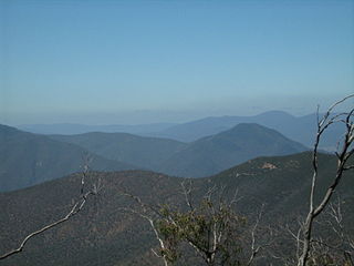
The Brindabella Range, commonly called The Brindabellas, is a mountain range located in Australia, on a state and territory border of New South Wales and the Australian Capital Territory (ACT). The range rises to the west of Canberra, the capital city of Australia, and includes the Namadgi National Park in the ACT and the Bimberi Nature Reserve and Brindabella National Park in New South Wales. The Brindabellas are visible to the west of Canberra and form an important part of the city's landscape.
The Division of Namadgi was an Australian Electoral Division in the Australian Capital Territory. It was located in the southern suburbs of Canberra, and included all suburbs in the district of Tuggeranong, the southern Woden Valley suburbs of Chifley, Farrer, Isaacs, Mawson, Pearce and Torrens, and the remainder of the ACT south and west of the Murrumbidgee River.

The Cotter River, a perennial river of the Murrumbidgee catchment within the Murray-Darling basin, is located in the Australian Capital Territory, Australia. The Cotter River, together with the Queanbeyan River, is one of two rivers that provides potable water to the Canberra and Queanbeyan region.
The Ngunnawal are an indigenous Australian people of southern New South Wales and the Australian Capital Territory.

The Gudgenby River, a perennial river that is part of the Murrumbidgee catchment within the Murray-Darling basin, is located in the Australian Capital Territory, Australia.
Orroral River, a perennial stream of the Murrumbidgee catchment within the Murray-Darling basin, is located in the Australian Capital Territory, Australia.
The history of the Australian Capital Territory (ACT) as a separate administrative division began in 1911, when it was transferred from New South Wales to the Australian federal government. The territory contains Australia's capital city Canberra and various smaller settlements. Until 1989, it also administered the Jervis Bay Territory, a small coastal region.

The Bimberi Nature Reserve is a protected nature reserve located in the Brindabella Range of New South Wales, in eastern Australia. The 10,868-hectare (26,860-acre) reserve is situated approximately 30 km (19 mi) south west of Canberra, which is in the Australian Capital Territory.
Naas Valley is an area south of Canberra, Australia in the Brindabella Ranges which was first settled by Europeans in 1834. The watershed of Naas Creek forms the southern and south-eastern boundary of the Australian Capital Territory, as specified in the Seat of Government Acceptance Act 1909.
Mount Coree is a mountain with an elevation of 1,421 metres (4,662 ft) AHD that is located within the Brindabella Range on the border between the Australian Capital Territory and New South Wales, Australia. The summit of the mountain is located in the Australian Capital Territory.

Skiing in the Australian Capital Territory refers to snow skiing in the Australian Capital Territory (ACT). The highest mountain in the ACT is Bimberi Peak. Recreational skiing commenced with the formation of the Canberra Alpine Club in 1934. Since the 1930s, the ACT has had intermittent and limited alpine skiing facilities. Downhill ski facilities returned to the ACT at Corin Forest in 2016, after a two decade hiatus.

Gibraltar Creek, a perennial stream that is part of the Murrumbidgee catchment within the Murray-Darling basin, is located in the Australian Capital Territory, Australia.

Paddys River, a perennial stream that is part of the Murrumbidgee catchment within the Murray-Darling basin, is located in the Australian Capital Territory, Australia.

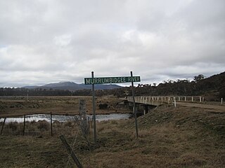
Shannons Flat is a locality in the Monaro region of New South Wales, Australia. The town is in the Snowy Monaro Regional Council local government area, sandwiched between the southern border of the Namadgi National Park in the Australian Capital Territory and the Murrumbidgee River. Shannons Flat also adjoins the NSW localities of Yaouk, Bolaro, Murrumbucca, Bredbo and Billilingra. It is about 308 kilometres (191 mi) south west of the state capital, Sydney, and 70 kilometres (40 mi) from the Australian national capital of Canberra. It is just over 40 kilometres (25 mi) north west of the regional centre, Cooma.
The Tidbinbilla River, a perennial stream that is part of the Murrumbidgee catchment within the Murray-Darling basin, is located in the Australian Capital Territory, Australia.
The Australian Alps National Parks and Reserves is a group of eleven protected areas consisting of national parks, nature reserves and one wilderness park located in the Australian Capital Territory, New South Wales and Victoria and which was listed as a "place" on the Australian National Heritage List on 7 November 2008 under the Environment Protection and Biodiversity Conservation Act 1999. The listing which covers an area of 16,531.80 square kilometres (6,382.96 sq mi), contains the vast majority of alpine and sub-alpine environments in Australia. The listing includes the following protected areas - Alpine, Baw Baw, Brindabella, Kosciuszko, Mount Buffalo, Namadgi and Snowy River national parks; the Avon Wilderness Park, and the Bimberi, Scabby Range and Tidbinbilla nature reserves.
Yaouk is a locality in the Snowy Monaro Region, New South Wales, Australia. It lies in open grassland valleys surrounded by mountains on both sides of the Murrumbidgee River, downstream from and east of the Tantangara Dam, north of Adaminaby, east of the Kosciuszko National Park and south of the Namadgi National Park in the Australian Capital Territory, but separated from it by the mountainous Scabby Range. It is about 110 km south of Canberra and about 75 km northwest of Cooma. At the 2016 census, it had a population of 25.
