The history of Canberra details the development of the city of Canberra from the time before European settlement to the city's planning by the Chicago architect Walter Burley Griffin in collaboration with Marion Mahony Griffin, and its subsequent development to the present day.

Lake Burley Griffin is an artificial lake in the centre of Canberra, the capital of Australia. It was completed in 1963 after the Molonglo River—which ran between the city centre and Parliamentary Triangle—was dammed. It is named after Walter Burley Griffin, the American architect who won the competition to design the city of Canberra.

The Molonglo River, a perennial river that is part of the Murrumbidgee catchment within the Murray–Darling basin, is located in the Monaro and Capital Country regions of New South Wales and the Australian Capital Territory, in Australia.
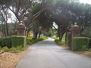
Acton is a suburb of Canberra, ACT, Australia. Acton covers an area west of the CBD, bordered by Black Mountain to the west and Lake Burley Griffin in the south. The Australian National University campus covers most of the suburb, though also located in Acton is the National Film and Sound Archive, a branch of the CSIRO and the National Museum of Australia.

The Division of Fenner is an Australian Electoral Division in the Australian Capital Territory and the Jervis Bay Territory. As of the 2018 redistribution, it includes Gungahlin and the part of Belconnen north of Belconnen Way and west of Eastern Valley Way, Aikman Drive and William Slim Drive. It also includes the Jervis Bay Territory.

The Division of Canberra is an Australian electoral division in the Australian Capital Territory. It is named for the city of Canberra, Australia's national capital, and includes all of central Canberra, Kowen, Majura, as well as part of Weston Creek, Woden Valley, Molonglo Valley, Belconnen, and Jerrabomberra. It is currently held by Alicia Payne of the Labor Party.
The Canberra Golf Club, later known as the Royal Canberra Golf Club, was formed in 1926. Its original grounds were behind the Hotel Canberra on the river flats on both sides of the Molonglo River.

Lennox Gardens, a park in Canberra, Australia, lying on the south side of Lake Burley Griffin, close to Commonwealth Avenue Bridge and Albert Hall in the suburb of Yarralumla. Before the construction of Lake Burley Griffin a road ran through the present garden, this road being one of two main crossing points across the Molonglo River. The name of the road was Lennox Crossing from which the present garden takes its name. The northern segment of the road is still present on Acton peninsula. The garden was officially named in 1963. Lennox Crossing was named after David Lennox, an early bridge builder in NSW and Victoria.

The Queanbeyan River, a perennial stream that is part of the Molonglo catchment within the Murray–Darling basin, is located in the Monaro and Capital Country regions of New South Wales and the Australian Capital Territory, in Australia. The river is 104 kilometres (65 mi) in length with a catchment area of 96,000 hectares. The Queanbeyan River and the Cotter River meet the potable water supply needs of the Canberra and Queanbeyan region and whose water quality is specifically protected under Federal legislation.
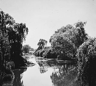
The Molonglo Plain generally refers to the flood plain of the Molonglo River and specifically the one located in the Australian Capital Territory that was inundated during the mid-1960s in order to create Lake Burley Griffin. This plain was one of fours plains - the Ginninderra Plain, the Limestone Plain, and the Tuggeranong Plain are the others - upon which the city of Canberra is situated.
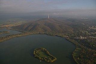
Springbank Island is an island located on Lake Burley Griffin in Canberra, Australian Capital Territory. Springbank Island is named after a former agricultural property that was partially submerged to create Lake Burley Griffin. An elevated part of the former property now comprises the island.
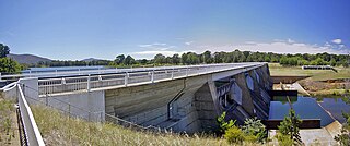
Scrivener Dam, a concrete gravity dam that impounds Molonglo River, is located in Canberra, Australian Capital Territory, Australia. The dam creates Lake Burley Griffin, that was established for recreational and ornamental purposes. Named in honour of surveyor, Charles Scrivener, the dam was officially inaugurated on 20 September 1964 and the official filling of the lake commemorated on 17 October 1964, by the Prime Minister, Robert Menzies.

The history of Lake Burley Griffin, an artificial body of water in Canberra, the capital of Australia, is a long one. Following its initial design in the 1910s, extensive political disputes occurred until it was finally built in the 1960s.

The Acton Peninsula is located on the northern shore of Lake Burley Griffin, in the centre of Canberra, the capital of Australia.
Jerrabomberra Creek, a partly perennial stream of the Murrumbidgee catchment within the Murray-Darling basin, is located in the Capital Country region spanning both New South Wales and the Australian Capital Territory, Australia.
Scott's Crossing Road was a former roadway connecting north and south Canberra, across the Molonglo River floodplain. It was named after John Scott, who was an early settler in the region, and whose homestead was located at its southern end. It was submerged by the filling of Lake Burley Griffin.

The Australian National University Boat Club is the rowing club of Australian National University and is based in Canberra, Australia, on the lower reaches of Sullivan's Creek, two hundred metres from the Lake Burley Griffin. Founded in 1964, the ANU Boat Club is Canberra's oldest rowing club. The present club boathouse has been located on the banks of Sullivan's creek since 1971.
The division of Canberra was one of the two electorates of the unicameral Australian Capital Territory House of Assembly. It elected 9 members in 1975 and 1979, and 10 members in 1982. It was named for the city of Canberra, Australia's national capital, and included the districts of Tuggeranong, Weston Creek and Woden Valley, along with the rest of the ACT south of the Molonglo River and Lake Burley Griffin.

The Commonwealth Avenue Bridge are two parallel pre-stressed concrete box girder road bridges that carry Commonwealth Avenue across Lake Burley Griffin, and connect Parkes and City in Canberra, in the Australian Capital Territory, Australia.
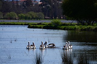
Jerrabomberra Wetlands Nature Reserve is a nationally important group of small wetlands in central Canberra. The Wetlands area is on a part of the Molonglo River - Jerrabomberra Creek floodplain that became permanently inundated when the Molonglo River was dammed to form Lake Burley Griffin in 1964.

