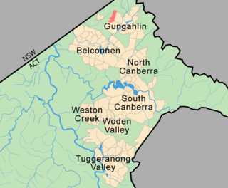
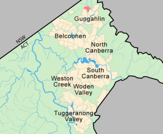
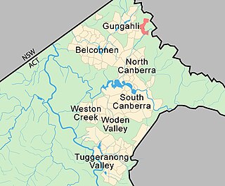
The District of Gungahlin is one of the original eighteen districts of the Australian Capital Territory used in land administration. The district is subdivided into divisions (suburbs), sections and blocks. Gungahlin is an Aboriginal word meaning either "white man's house" or "little rocky hill".

Aranda is a suburb in the district of Belconnen, in the Australian capital city of Canberra. Located at the western foot of Black Mountain and bounded on two sides by nature park, the suburb is characterised by its bush setting. During the planning and development of the suburb, a large proportion of large native trees – predominantly eucalypts – were left in place.

Taylor is a suburb in Gungahlin, Canberra, Australia. Development of the suburb began in 2017. It is named after magazine publisher Florence Taylor OBE, who was editor of and writer for several Australian building industry journals including the influential Building magazine. The suburb is approximately 4 km from the Gungahlin Town Centre and 16 km from the centre of Canberra and bounded by Horse Park Drive. The suburb is located in north Gungahlin near the existing suburb of Ngunnawal and adjacent to the suburbs of Casey and Moncrieff.

Jacka is a suburb of Gungahlin, Canberra, the National Capital of Australia. The suburb was gazetted on 25 April 2001 and development began in 2013. It had some residents at the beginning of 2014. The suburb is named after Albert Jacka, the first Australian to be decorated with the Victoria Cross during the First World War, receiving the medal for his actions during the Gallipoli Campaign. Jacka is located in north Gungahlin adjacent to the existing suburb of Amaroo and the future suburbs of Taylor, Bonner and Moncrieff. The suburb is located approximately 4 km from the Gungahlin Town Centre and 16 km from the centre of Canberra.

Mitchell is a light-industrial estate of Canberra, Australia in the district of Gungahlin. Mitchell was named in honour of Major Sir Thomas Livingstone Mitchell, an explorer of inland New South Wales and Surveyor-General of New South Wales. The streets in Mitchell are named after Australian industrialists.

Amaroo is a suburb in the Canberra, Australia district of Gungahlin and was gazetted on 18 October 1991. Amaroo – which means ‘a beautiful place’ in one of the local Aboriginal dialects. Place names in Amaroo such as Shoalhaven Avenue are named after Australian rivers and lakes. Amaroo is adjacent to the suburbs of Ngunnawal, Gungahlin, Moncrieff, Forde, Bonner and Jacka. The suburb is bounded by Mirrabei Drive and Horse Park Drive and Gundaroo Drive. The suburb is located approximately 1 km from the Gungahlin Town Centre and 12 km from the centre of Canberra.

Gungahlin is a suburb in the Canberra, Australia district with the same name; Gungahlin. The postcode is 2912. Gungahlin is the name for the entire district, and also the town centre, but it is also the name of the suburb which Gungahlin Town Centre is in.

Harrison is a suburb of the district of Gungahlin in Canberra, Australia. The suburb is named after the former city planner Peter Harrison, who was instrumental in reviving Walter Burley Griffin's plan for the National Capital. The suburb is adjacent to the suburbs of Franklin, Gungahlin, Throsby, Kenny and the industrial estate Mitchell. Harrison's place names reflects those of "natural features, waterfalls, plains, tablelands and plateaux". The suburb is located approximately 2 km east of the Gungahlin Town Centre and about 10 km from the centre of Canberra.

Ngunnawal is a suburb in the district of Gungahlin in Canberra, Australia. The suburb is named in tribute to the Ngunnawal people, the original inhabitants of the area. The suburb was gazetted on 24 April 1992. Ngunnawal is adjacent to the suburbs of Nicholls, Casey and Amaroo and Taylor. It is bounded by Gungahlin Drive, Horse Park Drive, Gundaroo Drive and Mirrabei Drive. Ginninderra Creek is situated near Ngunnawal's eastern boundary. The suburb is located approximately 4 km from the Gungahlin Town Centre and about 13 km from the centre of Canberra.

Nicholls is a suburb in the Canberra, Australia district of Gungahlin. It was named after Sir Douglas Nicholls (1906–1988) who was born at Cummeragunja Aboriginal mission, New South Wales and who was a footballer, pastor, activist and a former Governor of South Australia and was gazetted on 18 October 1991. Streets are named after various sportsmen and sportswomen.

Palmerston is a suburb in the Canberra, Australia district of Gungahlin. The postcode is 2913. The suburb is named after George Thomas Palmer (1784–1854) who established a settlement in the Canberra region in 1826 called Palmerville, which was later renamed Ginninderra. It was gazetted on 20 March 1991. Streets are named after mountains and mountain ranges of Australia, with the main street called Kosciuszko Avenue. It is next to the suburbs of Nicholls, Gungahlin, Crace and Franklin. It was the second suburb to be developed in the Gungahlin district, after the industrial suburb of Mitchell. It is bounded by Gungahlin drive and Gundaroo drive.

Hall is a township in the north of the Australian Capital Territory, Australia. At the 2016 census, the village had a population of 271 people. It is surrounded by open country and has a rural appearance. Hall has retained a village character. The township features historic buildings that existed before the establishment of Canberra.

Bonner is a suburb in the district of Gungahlin in Canberra in Australia. The suburb is named in memory after Senator Neville Bonner, Australia's first Indigenous parliamentarian who served the people of Queensland during the years 1971-1984. The suburb is bounded by Horse Park Drive, Mulligans Flat Road, and Roden Cutler Drive and is approximately 4 km (2.5 mi) from the Gungahlin Town Centre and 16 km (9.9 mi) from the centre of Canberra. It is adjacent to the suburbs of Jacka, Amaroo and Forde. Settlement of the suburb began in 2010 and it had an estimated population of 6,730 at the 2016 census.
Casey is a suburb in Canberra, Australia, approximately 4 km from the Gungahlin Town Centre and about 13 km from the centre of Canberra. The suburb is named after Richard Casey, Baron Casey an Australian politician, diplomat and later the 16th Governor-General of Australia. It is bound by Horse Park Drive and Clarrie Hermes Drive. Casey is located in north-west Gungahlin, adjacent to the suburbs of Nicholls and Ngunnawal, and the future suburbs of Kinlyside, Taylor and Moncrieff.

Crace is a suburb of Canberra, Australia in the district of Gungahlin. It was named after Edward Kendall Crace an original settler in the Gungahlin area. Streets in Crace are named after parishes and land divisions from colonial times. It is bounded by the Barton Highway, Gundaroo Drive, Nudurr Drive and Gungahlin Drive. Located in the suburb is the Canberra Nature Park of Gungaderra Grasslands nature reserve. At the 2016 census, it had a population of 4,459.

Forde is a northern suburb of the Canberra, Australia district of Gungahlin. It is named in honour of Frank Forde, who served as Prime Minister of Australia for a week in 1945 following the untimely death of John Curtin. The suburb abuts the Mulligans Flat Reserve and is adjacent to the suburbs of Amaroo, Throsby and Bonner. The suburb is bound to the south and west respectively by Horse Park Drive and Gundaroo Road. Settlement of the suburb began in 2008 and it had an estimated population of 4,308 at the 2016 census.

Franklin is a suburb of Canberra, Australia in the district of Gungahlin. It is named after the novelist Miles Franklin. The streets in Franklin are named after writers. It comprises an area of approximately 256 hectares. It is bounded by Flemington Road to the north and east, Wells Station Drive to the south, and Gungahlin Drive to the west. Franklin is mainly a residential area with higher density, mixed-use development along Flemington Road including a local shopping centre and other retail and commercial tenancies.
Moncrieff is a designated suburb in the Gungahlin district of Canberra, the National Capital of Australia. The name was gazetted in April 1991, with initial land releases becoming available to developers in June 2014. It is named after Gladys Moncrieff, an Australian singer of the 1920-1930s musical era who was dubbed 'Australia's Queen of Song'. The suburb is located in north Gungahlin adjacent to the existing suburb of to the suburbs of Ngunnawal, Amaroo and the future suburbs of Taylor and Jacka. The suburb is located approximately 4 km from the Gungahlin Town Centre and 16 km from the centre of Canberra and is bounded by Mirrabei Drive and Horse Park Drive.
Throsby is a designated suburb of Canberra, Australia in the district of Gungahlin. The suburb is adjacent to the suburbs of Kenny and Harrison and is bounded by the Federal Highway to the east, the ACT/NSW border to the north, Horse Park Drive to the south and the Goorooyarroo nature reserve to the west. The suburb is named after the explorer Charles Throsby who was one of the first Europeans to open up the lands west of the Blue Mountains to grazing and agriculture.

Blundells Cottage is a six-roomed stone cottage located on the northern shore of Lake Burley Griffin, in Canberra, Australia. When it was built this was the Molonglo River floodplain.