Gungahlin is a district in the Australian Capital Territory, one of fastest growing regions in Australia. The district is subdivided into suburbs, sections and blocks. Gungahlin is an Aboriginal word meaning either "white man's house" or "little rocky hill".

Lyneham is a suburb of Canberra, Australia in the North Canberra district. It is named after Sir William Lyne, premier of New South Wales from 1899 to 1901. The suburb name was gazetted in 1928, but development did not commence until 1958. The streets of Lyneham are named after artists and people associated with the development of early Canberra.

Aranda is a suburb in the district of Belconnen, in the Australian capital city of Canberra. Located at the western foot of Black Mountain and bounded on two sides by nature park, the suburb is characterised by its bush setting. During the planning and development of the suburb, a large proportion of large native trees – predominantly eucalypts – were left in place.
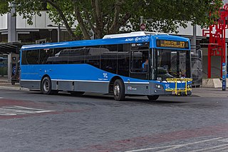
ACTION is a bus operator in Canberra, Australia, and is owned by the Government of the Australian Capital Territory.
The suburbs of the Australian Capital Territory are organised into a hierarchy of districts, town centres, group centres, local suburbs and other industrial areas and villages. While these divisions have no formal role in the governance or administration of the city, they formed a basis for the planning and development of the city and are significant to the city's commercial and social activities.

Bruce is a suburb of the Belconnen district of Canberra, that is located within the Australian Capital Territory, Australia. The suburb was gazetted on 6 June 1968 and named for The Viscount Bruce of Melbourne (1883–1967), the eighth Prime Minister of Australia and the first Chancellor of the Australian National University.

Gungahlin is a suburb in the Canberra, Australia district with the same name; Gungahlin. The postcode is 2912. Gungahlin is the name for the entire district, and also the town centre, but it is also the name of the suburb which Gungahlin Town Centre is in.

Harrison is a suburb of the district of Gungahlin in Canberra, Australia. The suburb is named after the former city planner Peter Harrison, who was instrumental in reviving Walter Burley Griffin's plan for the National Capital. The suburb is adjacent to the suburbs of Franklin, Gungahlin, Throsby, Kenny and the industrial estate Mitchell. Harrison's place names reflects those of "natural features, waterfalls, plains, tablelands and plateaux". The suburb is located approximately 2 km east of the Gungahlin Town Centre and about 10 km from the centre of Canberra.

Ngunnawal is a suburb in the district of Gungahlin in Canberra, Australia. The suburb is named in tribute to the Ngunnawal people, the original inhabitants of the area. The suburb was gazetted on 24 April 1992. Ngunnawal is adjacent to the suburbs of Nicholls, Casey, Moncrieff, Amaroo and Gungahlin. It is bounded by Gungahlin Drive, Horse Park Drive, Gundaroo Drive and Mirrabei Drive. Ginninderra Creek is situated near Ngunnawal's eastern boundary. The suburb is located approximately 4 km from the Gungahlin Town Centre and about 13 km from the centre of Canberra.

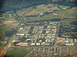
Palmerston is a suburb in the Canberra, Australia district of Gungahlin. The postcode is 2913. The suburb is named after George Thomas Palmer (1784–1854) who established a settlement in the Canberra region in 1826 called Palmerville, which was later renamed Ginninderra. It was gazetted on 20 March 1991. Streets are named after mountains and mountain ranges of Australia, with the main street called Kosciuszko Avenue. It is next to the suburbs of Nicholls, Gungahlin, Crace and Franklin. It was the second suburb to be developed in the Gungahlin district, after the industrial suburb of Mitchell. It is bounded by Gungahlin drive and Gundaroo drive.

Crace is a suburb of Canberra, Australia in the district of Gungahlin. It was named after Edward Kendall Crace an original settler in the Gungahlin area. Streets in Crace are named after parishes and land divisions from colonial times. It is bounded by the Barton Highway, Gundaroo Drive, Nudurr Drive and Gungahlin Drive. Located in the suburb is the Canberra Nature Park of Gungaderra Grasslands nature reserve. At the 2016 census, it had a population of 4,459.

Franklin is a suburb of Canberra, Australia in the district of Gungahlin. It is named after the novelist Miles Franklin. The streets in Franklin are named after writers. It comprises an area of approximately 256 hectares. It is bounded by Flemington Road to the north and east, Well Station Drive to the south, and Gungahlin Drive to the west. Franklin is mainly a residential area with higher density, mixed-use development along Flemington Road including a local shopping centre and other retail and commercial tenancies.

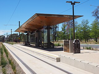
The Canberra light rail network, also known as Canberra Metro, is a light rail system serving the city of Canberra, Australia. The initial 12-kilometre (7.5 mi) line links the northern town centre of Gungahlin to the city centre (Civic) and has 14 stops. Services commenced on 20 April 2019. The 14th stop at Sandford Street in Mitchell commenced operation in September 2021.

Dickson Interchange is a transport interchange in Dickson, an inner-northern suburb of Canberra. The interchange allows transfers between the Canberra Metro light rail network and local ACTION bus services. As part of the construction of the Civic to Gungahlin light rail line, a new $4 million bus interchange opened in 2018. The interchange was built on land compulsorily acquired by the ACT Government in 2015, the terms of which were not disclosed to the public. Construction allowed direct access for bus and pedestrian traffic between Northbourne Avenue and Challis Street, as well as accommodation for up to nine local bus routes, a new taxi rank, kiss and ride facilities and signalised pedestrian crossings. The new facilities became an important connection point for commuters under a redesigned timetable that integrated bus and light rail services in early 2019.

EPIC and Racecourse is a light rail station on the Canberra Metro R1 Civic to Gungahlin line. Although technically located in the suburb of Lyneham, the station primarily serves Exhibition Park in Canberra (EPIC) - home to major annual events including Summernats, the National Folk Festival and Royal Canberra Show as well as Thoroughbred Park, the city's main venue for horse racing. The station is generally quiet outside of major events at these venues, serving the least passengers of any station on the line in the first 10 months of operation. Prior to the opening of the line, a park and ride facility was in use for ACTION bus commuters, this was temporarily relocated in 2016, but reopened in 2019 once construction was completed. In addition to the park and ride facilities, the station also provides bicycle racks. EPIC and Racecourse is unique on the line as it is the only station that is not constructed within the centre median of a major road.

Well Station Drive is a light rail station on the Canberra Metro R1 Civic to Gungahlin line, located at the intersection of Well Station Drive and Flemington Road. It serves the residential suburb of Harrison and is the closest station to many businesses in Mitchell. The station's location and lack of suitable footpaths makes access to the industrial area difficult for pedestrians, leading to safety concerns within the community. Bicycle racks and "kiss and ride" bays are currently installed around the intersection adjacent to the station.

Gungahlin Place is a transport interchange located in the Gungahlin Town Centre. It is the northern terminus of the Canberra Metro R1 Civic to Gungahlin line and is an important connection point between light rail and bus transport. The current bus interchange opened on 21 April 2018. Despite the station being named Gungahlin Place, the light rail platforms are actually located on a section of Hibberson Street that has been closed to road traffic. Light rail service began in April 2019.

Sandford Street is a light rail station in Australia on the Canberra Metro R1 Civic to Gungahlin line, located at the intersection of Flemington Road, Sandford Street and Morriset Road in Mitchell. The station serves the surrounding business and industrial precinct, and will support future residential development in the neighbouring suburb of Kenny. Bicycle racks are provided around the intersection adjacent to the station. It is the only station on the Civic to Gungahlin route that did not open with stage 1 of the network.
Phillip Avenue is a light rail station in Australia on the Canberra Metro R1 Civic to Gungahlin line, located on the Federal Highway at the intersection of Phillip Avenue. The station primarily serves the suburb of Watson although it is close to Exhibition Park in Canberra and a few businesses in the northern part of Lyneham, providing an alternative to the EPIC and Racecourse station during major events. Bicycle racks are provided for commuters adjacent to the station, but there is no dedicated parking or "kiss and ride" bays available.

Alinga Street light rail station is the terminus of the Canberra Metro R1 light rail line. It opened on 20 April 2019. As the main connection point for bus services to Canberra's southern districts as well as to Queanbeyan and Yass, Alinga Street is by far the busiest station on the route, with 37% of all light rail passengers beginning or ending a journey here in the first 10 months of operation.