
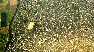
Gungahlin is a district in the Australian Capital Territory, one of fastest growing regions in Australia. The district is subdivided into suburbs, sections and blocks. Gungahlin is an Aboriginal word meaning either "white man's house" or "little rocky hill".

Charnwood is a suburb in the Belconnen district of Canberra located within the Australian Capital Territory, Australia.
Kinlyside is a rural locality in the Australian Capital Territory. It was gazetted in 1991 as a planned outer suburb of Gungahlin. It was never released for development, and the governing Labor Party campaigned at the 2004 election and 2008 election on the policy of making Kinlyside a nature reserve instead. In 2013, it was set aside as a protected area that would remain undeveloped under an environmental offsets plan associated with increased development in Gungahlin. As of 2019, it remains a gazetted locality in the Territory Plan.

Jacka is a suburb of Gungahlin, Canberra, the National Capital of Australia. The suburb was gazetted on 25 April 2001 and development began in 2013. It had some residents at the beginning of 2014. The suburb is named after Albert Jacka, the first Australian to be decorated with the Victoria Cross during the First World War, receiving the medal for his actions during the Gallipoli Campaign. Jacka is located in north Gungahlin adjacent to the suburbs of Amaroo, Taylor, Bonner and Moncrieff. The suburb is located approximately 4 km from the Gungahlin Town Centre and 16 km from the centre of Canberra.
Spence is a residential suburb in the Belconnen district of Canberra, located within the Australian Capital Territory, Australia. The suburb is named after William Spence (1846–1926), one of the founders of the Australian Workers' Union and later a member of the first Australian House of Representatives. It was gazetted on 2 November 1972. Streets are named after trade unionists.

Amaroo is a suburb in the Canberra, Australia district of Gungahlin and was gazetted on 18 October 1991. Amaroo means 'a beautiful place' in Nyoongar. Place names in Amaroo such as Shoalhaven Avenue are named after Australian rivers and lakes. Amaroo is adjacent to the suburbs of Ngunnawal, Gungahlin, Moncrieff, Forde, Bonner and Jacka. The suburb is bounded by Mirrabei Drive and Horse Park Drive and Gundaroo Drive. The suburb is located approximately 1 km from the Gungahlin Town Centre and 15 km from the centre of Canberra.

Harrison is a suburb of the district of Gungahlin in Canberra, Australia. The suburb is named after the former city planner Peter Harrison, who was instrumental in reviving Walter Burley Griffin's plan for the National Capital. The suburb is adjacent to the suburbs of Franklin, Gungahlin, Throsby, Kenny and the industrial estate Mitchell. Harrison's place names reflects those of "natural features, waterfalls, plains, tablelands and plateaux". The suburb is located approximately 2 km east of the Gungahlin Town Centre and about 10 km from the centre of Canberra.

Ngunnawal is a suburb in the district of Gungahlin in Canberra, Australia. The suburb is named in tribute to the Ngunnawal people, the original inhabitants of the area. The suburb was gazetted on 24 April 1992. Ngunnawal is adjacent to the suburbs of Nicholls, Casey, Moncrieff, Amaroo and Gungahlin. It is bounded by Gungahlin Drive, Horse Park Drive, Gundaroo Drive and Mirrabei Drive. Ginninderra Creek is situated near Ngunnawal's eastern boundary. The suburb is located approximately 4 km from the Gungahlin Town Centre and about 13 km from the centre of Canberra.

Nicholls is a suburb in the Canberra, Australia district of Gungahlin. It was named after Sir Douglas Nicholls (1906–1988) who was born at Cummeragunja Aboriginal mission, New South Wales. Nicholls was a footballer, pastor, activist, and Governor of South Australia, 1976–1977. In line with the philosophy of naming Canberra's streets, those of Nicholls are named after sportspeople. The suburb incorporates a large shallow body of water, designated Gungahlin Pond, with The Lakes golf course and the greatest number of residential streets on one side and a small cluster of residential streets, the "pondside promenade", named after birds, on the other. There is no direct connecting road between the two.

Palmerston is a suburb in the Canberra, Australia district of Gungahlin. The postcode is 2913. The suburb is named after George Thomas Palmer (1784–1854) who established a settlement in the Canberra region in 1826 called Palmerville, which was later renamed Ginninderra. It was gazetted on 20 March 1991. Streets are named after mountains and mountain ranges of Australia, with the main street called Kosciuszko Avenue. It is next to the suburbs of Nicholls, Gungahlin, Crace and Franklin. It was the second suburb to be developed in the Gungahlin district, after the industrial suburb of Mitchell. It is bounded by Gungahlin drive and Gundaroo drive.
Kambah is the northernmost suburb in the district of Tuggeranong, Canberra. It is located just south of Mount Taylor in the Canberra Nature Park. It is located north of the suburbs of Greenway and Wanniassa. It is bounded by Sulwood Drive to the north and Athllon Drive to the south-east.

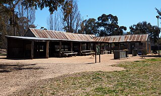
Hall is a town in the district of Hall, in the Australian Capital Territory in Australia. Is situated on the north side of the Australian Capital Territory. At the 2021 census, the village had a population of 298 people. It is surrounded by open country and has a rural appearance. Hall has retained a village character. The town features historic buildings that existed before the establishment of Canberra.
Bonner is a suburb in the district of Gungahlin in Canberra in Australia. The suburb is named in memory after Senator Neville Bonner, Australia's first Indigenous parliamentarian who served the people of Queensland during the years 1971–1984. The suburb is bounded by Horse Park Drive, Mulligans Flat Road, and Roden Cutler Drive and is approximately 4 km (2.5 mi) from the Gungahlin Town Centre and 16 km (9.9 mi) from the centre of Canberra. It is adjacent to the suburbs of Jacka, Amaroo and Forde. Settlement of the suburb began in 2010 and it had an estimated population of 6,730 at the 2016 census.

Casey is a suburb in Canberra, Australia, approximately 4 km from the Gungahlin Town Centre and about 13 km from the centre of Canberra. The suburb is named after Richard Casey, Baron Casey an Australian politician, diplomat and later the 16th Governor-General of Australia. It is bound by Horse Park Drive and Clarrie Hermes Drive. Casey is located in north-west Gungahlin, adjacent to the suburbs of Nicholls and Ngunnawal, and the future suburbs of Taylor and Moncrieff.
Kenny is a designated suburb in the Canberra, Australia district of Gungahlin. The suburb is named in honour of Elizabeth Kenny, an Australian who pioneered muscle rehabilitation practices which serve as the foundation of physiotherapy. It is adjacent to the suburbs of Watson, Lyneham, the Mitchell industrial estate, Harrison and Throsby and bounded by the Federal Highway to the east and Horse Park Drive to the north. The suburb Kenny is situated about 4 km from the Gungahlin Towncentre and 8 km from the centre of Canberra.

Moncrieff is a suburb in the Gungahlin district of Canberra, the National Capital of Australia. The name was gazetted in April 1991, with initial land releases becoming available to developers in June 2014. It is named after Gladys Moncrieff, an Australian singer of the 1920-1930s musical era who was dubbed 'Australia's Queen of Song'. The suburb is in north Gungahlin, adjacent to the existing suburbs of Ngunnawal and Amaroo and the future suburbs of Taylor and Jacka. The suburb is located approximately 4 km from the Gungahlin Town Centre and 16 km from the centre of Canberra, and is bounded by Mirrabei Drive and Horse Park Drive. It is home to the Moncrieff Community Recreation Park, which was voted the ACT's favourite playground in 2021.
Throsby is a designated suburb of Canberra, Australia in the district of Gungahlin. The suburb is adjacent to the suburbs of Kenny and Harrison and is bounded by the Federal Highway to the east, the ACT/NSW border to the north, Horse Park Drive to the south and the Goorooyarroo nature reserve to the west. The suburb is named after the explorer Charles Throsby who was one of the first Europeans to open up the lands west of the Blue Mountains to grazing and agriculture.
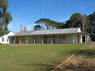
Gold Creek Homestead is a 140-year-old stone and brick building located off Gungahlin Drive in Ngunnawal a north-western suburb of Canberra, Australia. It is adjacent to the Grove Ngunnawal retirement village currently being developed by Lend Lease.
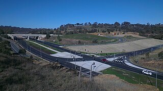
Horse Park Drive is an arterial road in the Gungahlin district of Canberra, Australia. It is named for the homestead Horse Park, built in 1853 which is located in the suburb of Jacka. The road provides a bypass of the Gungahlin town centre, linking the western suburbs of the district to the Federal Highway to Goulburn and the Majura Parkway, linking to the Monaro Highway and Canberra Airport.
