The District of Gungahlin is one of the original eighteen districts of the Australian Capital Territory used in land administration. The Gungahlin Region is one of fastest growing regions within Australia. The district is subdivided into divisions (suburbs), sections and blocks. Gungahlin is an Aboriginal word meaning either "white man's house" or "little rocky hill".

Aranda is a suburb in the district of Belconnen, in the Australian capital city of Canberra. Located at the western foot of Black Mountain and bounded on two sides by nature park, the suburb is characterised by its bush setting. During the planning and development of the suburb, a large proportion of large native trees – predominantly eucalypts – were left in place.
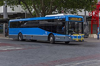
ACTION is a bus operator in Canberra, Australia owned by the ACT Government.

The suburbs of Canberra are organised into a hierarchy of districts, town centres, group centres, local suburbs and other industrial areas and villages. While these divisions have no formal role in the governance or administration of the city, they formed a basis for the planning and development of the city and are significant to the city's commercial and social activities.
Taylor is a suburb in Gungahlin, Canberra, Australia. Development of the suburb began in 2017. It is named after magazine publisher Florence Mary Taylor, who was editor of and writer for several Australian building industry journals including the influential Building magazine. The suburb is approximately 4 km from the Gungahlin Town Centre and 16 km from the centre of Canberra and bounded to the south by Horse Park Drive. One Tree Hill lies to the northwest on the border with New South Wales. The suburb is located in north Gungahlin adjacent to the suburbs of Moncrieff, Casey, Jacka and Ngunnawal.

Jacka is a suburb of Gungahlin, Canberra, the National Capital of Australia. The suburb was gazetted on 25 April 2001 and development began in 2013. It had some residents at the beginning of 2014. The suburb is named after Albert Jacka, the first Australian to be decorated with the Victoria Cross during the First World War, receiving the medal for his actions during the Gallipoli Campaign. Jacka is located in north Gungahlin adjacent to the suburbs of Amaroo, Taylor, Bonner and Moncrieff. The suburb is located approximately 4 km from the Gungahlin Town Centre and 16 km from the centre of Canberra.

Mitchell is a light-industrial estate of Canberra, Australia in the district of Gungahlin. Mitchell was named in honour of Major Sir Thomas Livingstone Mitchell, an explorer of inland New South Wales and Surveyor-General of New South Wales. The streets in Mitchell are named after Australian industrialists.
Watson is a suburb of Canberra, Australia in the North Canberra district. Watson is named after the third Prime Minister of Australia, John Christian Watson. The suburb name was gazetted on 7 April 1960. Streets in Watson are named after Australian judges and other legal professionals.

Gungahlin is a suburb in the Canberra, Australia district with the same name; Gungahlin. The postcode is 2912. Gungahlin is the name for the entire district, and also the town centre, but it is also the name of the suburb which Gungahlin Town Centre is in.

Ngunnawal is a suburb in the district of Gungahlin in Canberra, Australia. The suburb is named in tribute to the Ngunnawal people, the original inhabitants of the area. The suburb was gazetted on 24 April 1992. Ngunnawal is adjacent to the suburbs of Nicholls, Casey, Moncrieff, Amaroo and Gungahlin. It is bounded by Gungahlin Drive, Horse Park Drive, Gundaroo Drive and Mirrabei Drive. Ginninderra Creek is situated near Ngunnawal's eastern boundary. The suburb is located approximately 4 km from the Gungahlin Town Centre and about 13 km from the centre of Canberra.

Nicholls is a suburb in the Canberra, Australia district of Gungahlin. It was named after Sir Douglas Nicholls (1906–1988) who was born at Cummeragunja Aboriginal mission, New South Wales. Nicholls was a footballer, pastor, activist, and a former Governor of South Australia. Streets are named after various sportsmen and sportswomen.

Palmerston is a suburb in the Canberra, Australia district of Gungahlin. The postcode is 2913. The suburb is named after George Thomas Palmer (1784–1854) who established a settlement in the Canberra region in 1826 called Palmerville, which was later renamed Ginninderra. It was gazetted on 20 March 1991. Streets are named after mountains and mountain ranges of Australia, with the main street called Kosciuszko Avenue. It is next to the suburbs of Nicholls, Gungahlin, Crace and Franklin. It was the second suburb to be developed in the Gungahlin district, after the industrial suburb of Mitchell. It is bounded by Gungahlin drive and Gundaroo drive.
Bonner is a suburb in the district of Gungahlin in Canberra in Australia. The suburb is named in memory after Senator Neville Bonner, Australia's first Indigenous parliamentarian who served the people of Queensland during the years 1971–1984. The suburb is bounded by Horse Park Drive, Mulligans Flat Road, and Roden Cutler Drive and is approximately 4 km (2.5 mi) from the Gungahlin Town Centre and 16 km (9.9 mi) from the centre of Canberra. It is adjacent to the suburbs of Jacka, Amaroo and Forde. Settlement of the suburb began in 2010 and it had an estimated population of 6,730 at the 2016 census.

Casey is a suburb in Canberra, Australia, approximately 4 km from the Gungahlin Town Centre and about 13 km from the centre of Canberra. The suburb is named after Richard Casey, Baron Casey an Australian politician, diplomat and later the 16th Governor-General of Australia. It is bound by Horse Park Drive and Clarrie Hermes Drive. Casey is located in north-west Gungahlin, adjacent to the suburbs of Nicholls and Ngunnawal, and the future suburbs of Kinlyside, Taylor and Moncrieff.

Crace is a suburb of Canberra, Australia in the district of Gungahlin. It was named after Edward Kendall Crace an original settler in the Gungahlin area. Streets in Crace are named after parishes and land divisions from colonial times. It is bounded by the Barton Highway, Gundaroo Drive, Nudurr Drive and Gungahlin Drive. Located in the suburb is the Canberra Nature Park of Gungaderra Grasslands nature reserve. At the 2016 census, it had a population of 4,459.

Franklin is a suburb of Canberra, Australia in the district of Gungahlin. It is named after the novelist Miles Franklin. The streets in Franklin are named after writers. It comprises an area of approximately 256 hectares. It is bounded by Flemington Road to the north and east, Well Station Drive to the south, and Gungahlin Drive to the west. Franklin is mainly a residential area with higher density, mixed-use development along Flemington Road including a local shopping centre and other retail and commercial tenancies.

Moncrieff is a suburb in the Gungahlin district of Canberra, the National Capital of Australia. The name was gazetted in April 1991, with initial land releases becoming available to developers in June 2014. It is named after Gladys Moncrieff, an Australian singer of the 1920-1930s musical era who was dubbed 'Australia's Queen of Song'. The suburb is in north Gungahlin, adjacent to the existing suburbs of Ngunnawal and Amaroo and the future suburbs of Taylor and Jacka. The suburb is located approximately 4 km from the Gungahlin Town Centre and 16 km from the centre of Canberra, and is bounded by Mirrabei Drive and Horse Park Drive. It is home to the Moncrieff Community Recreation Park, which was voted the ACT's favourite playground in 2021.
Throsby is a designated suburb of Canberra, Australia in the district of Gungahlin. The suburb is adjacent to the suburbs of Kenny and Harrison and is bounded by the Federal Highway to the east, the ACT/NSW border to the north, Horse Park Drive to the south and the Goorooyarroo nature reserve to the west. The suburb is named after the explorer Charles Throsby who was one of the first Europeans to open up the lands west of the Blue Mountains to grazing and agriculture.

The Canberra light rail network, also known as Canberra Metro, is a light rail system serving the city of Canberra, Australia. The initial 12-kilometre (7.5 mi) line links the northern town centre of Gungahlin to the city centre (Civic) and has 14 stops. Services commenced on 20 April 2019. A 14th stop at Sandford Street in Mitchell commenced operation in September 2021.

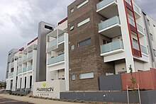
Well Station Drive is a light rail station on the Canberra Metro R1 Civic to Gungahlin line, located at the intersection of Well Station Drive and Flemington Road. It serves the residential suburb of Harrison and is the closest station to many businesses in Mitchell. The station's location and lack of suitable footpaths makes access to the industrial area difficult for pedestrians, leading to safety concerns within the community. Bicycle racks and "kiss and ride" bays are currently installed around the intersection adjacent to the station.