Dawson River (Queensland)

Last updated

Dawson
Dawson River near Moura.jpg
Dawson River near Moura
Australia Queensland relief location map.jpg
Red pog.svg
Location of Dawson River mouth in Queensland
EtymologyIn honour of Robert Dawson [1]
Location
Country Australia
State Queensland
Region Central Queensland
Towns Baralaba, Theodore, Taroom
Physical characteristics
Source Carnarvon Range
  locationnorthwest of Upper Dawson
  coordinates 25°17′52″S148°34′03″E / 25.29778°S 148.56750°E / -25.29778; 148.56750
  elevation642 m (2,106 ft)
Mouth confluence with the Mackenzie River to form the Fitzroy River
  location
northeast of Duaringa
  coordinates
24°57′50″S150°04′23″E / 24.96389°S 150.07306°E / -24.96389; 150.07306
  elevation
55 m (180 ft)
Length735 km (457 mi)
Basin size50,800 km2 (19,600 sq mi)
Basin features
River system Fitzroy River
Tributaries 
  right Don River (Central Queensland)
National parks Carnarvon National Park; Expedition National Park; Precipice National Park
[2]

The Dawson River is a river in Central Queensland, Australia. [3]

Contents

Course and features

The Dawson River rises at the eastern end of the Carnarvon Range in Boxvale State Forest and adjacent private lands. This is a rugged forested area of sandstone gorges in which the river is an ephemeral stream with some permanent, spring-fed waterholes. The Carnarvon Highway crosses the river in this headwater area before the upper section of the river drains southeast as an intermittent stream traversing the rugged Lonesome and Beilba sections of Expedition National Park, at the southern end of the Arcadia Valley. This upper section of the Dawson ends at the confluence with Hutton Creek, a spring-fed stream that marks the upper limit of permanent flow. The middle section of the Dawson River flows generally east from the Baroondah crossing to Taroom on the Leichhardt Highway and northeast to the Glebe Weir, where the river turns north and traverses the Precipice Range through Nathan Gorge, another rugged area of wooded sandstone ranges. From here the lower section of the river meanders through a broad valley of gently undulating lowlands and irrigated floodplains, being crossed again by the Leichhardt Highway at Theodore, and continuing north through Baralaba towards Duaringa, where it is crossed by the Capricorn Highway. A little further north, the Dawson River meets its confluence with the Mackenzie River to form the Fitzroy River. From source to confluence, the river is joined by sixty-four tributaries, including the Don River, and descends 587 metres (1,926 ft) over its 735-kilometre (457 mi) course. [2] Several weirs have been constructed along the lower Dawson river to provide water for cotton and dairy farming in the region. The river catchment covers an area of 50,800 square kilometres (19,600 sq mi). [4]

Expedition National Park and the Precipice National Park are protected areas along the Dawson River.

The Dawson River was one of a number of Queensland rivers affected by the 2010–11 Queensland floods. As the river inundated the town of Theodore it was completely evacuated, a first in Queensland's history. [5]

History

Yiman (also known as Iman and Jiman), Wuli Wuli , and Gangalu are Australian Aboriginal languages of the Dawson River in Central Queensland. The language region includes areas within the local government areas of Maranoa Regional Council and Banana Shire Council. [6]

Ludwig Leichhardt explored the area in 1844 and named the river in honour of Robert Dawson, one of Leichhardt's financial backers. [1]

The Hornet Bank massacre of settlers occurred along the Dawson near Taroom and was followed by reprisal attacks, massacres and dispersion of the indigenous Iman people.

In the 1920s, shortly after the First World War, Australian Labor Party politician Ted Theodore (1884-1950) launched an irrigation program on the Dawson River for returning soldiers. [7] His intentions was to provide them with arable land along the river for them to take up farming, thus eschewing a post-war recession. [7] After the 1922 Irrigation Act was passed, he started irrigation schemes on the Dawson River, for an initial 8,000 new farmers. [7] However, the scheme was abandoned after he realised the soil was unsuitable for farming and the returning soldiers had no agrarian skills. [7]

See also

Related Research Articles

<span class="mw-page-title-main">Carnarvon National Park</span> Protected area in Queensland, Australia

Carnarvon National Park is located in the Southern Brigalow Belt bioregion in the Maranoa Region in Central Queensland, Australia. The park is 593 km northwest of Brisbane. It began life as a 26,304-hectare (65,000-acre) reserve gazetted in 1932 to protect Carnarvon Gorge for its outstanding scenic values, its Indigenous and non-Indigenous cultural heritage, and its geological significance.

<span class="mw-page-title-main">Isla Gorge National Park</span> Protected area in Queensland, Australia

Isla Gorge is a national park in Queensland, Australia, 415 km northwest of Brisbane, gazetted in 1964. It contains a rest area with toilets and a camping area, situated along the Leichhardt Highway just south of Theodore.

<span class="mw-page-title-main">Fitzroy River (Queensland)</span> River in Queensland, Australia

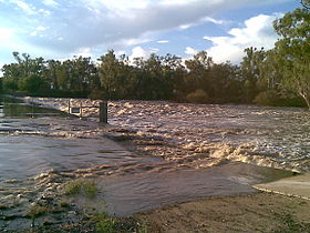
The Fitzroy River is a river in Central Queensland, Australia. Its catchment covers an area of 142,665 square kilometres (55,083 sq mi), making it the largest river catchment flowing to the eastern coast of Australia. It is also the largest river basin that discharges onto the Great Barrier Reef.

<span class="mw-page-title-main">Burdekin River</span> River in Queensland, Australia

The Burdekin River is a river in North and Far North Queensland, Australia. The river rises on the northern slopes of Boulder Mountain at Valley of Lagoons, part of the western slope of the Seaview Range, and flows into the Coral Sea at Upstart Bay over 200 kilometres (124 mi) to the southeast of the source, with a catchment area of approximately 130,000 square kilometres (50,000 sq mi). The Burdekin River is Australia's largest river by (peak) discharge volume.

<span class="mw-page-title-main">Central Queensland</span> Region in Queensland, Australia

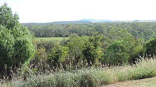
Central Queensland is an imprecisely-defined geographical division of Queensland that centres on the eastern coast, around the Tropic of Capricorn. Its major regional centre is Rockhampton. The region extends from the Capricorn Coast west to the Central Highlands at Emerald, north to the Mackay Regional Council southern boundary, and south to Gladstone. The region is also known as Capricornia. It is one of Australia's main coal exporting regions.

<span class="mw-page-title-main">Leichhardt Highway</span>

The Leichhardt Highway is a major transport route in Queensland, Australia. It is a continuation northward from Goondiwindi of the Newell Highway, via a 2.0-kilometre (1.2 mi) section of the Cunningham Highway.

<span class="mw-page-title-main">Theodore, Queensland</span> Town in Queensland, Australia

Theodore is a rural town and locality in the Shire of Banana, Queensland, Australia. In the 2016 census the locality of Theodore had a population of 438 people.

<span class="mw-page-title-main">Carnarvon Gorge</span> Gorge in Central Queensland, Australia

Carnarvon Gorge is located in the Southern Brigalow Belt bioregion in Central Queensland (Australia), 593 km northwest of Brisbane. Primarily created by water erosion, Carnarvon Gorge is around 30 kilometres long, located in Carnarvon National Park, and six hundred metres deep at the mouth. It is the most visited feature within Carnarvon National Park due to the diversity of experiences it contains and the ease with which it can be accessed. The closest towns are Injune and Rolleston.

<span class="mw-page-title-main">Taroom</span> Town in Queensland, Australia

Taroom is a town in the Shire of Banana and locality split between the Shire of Banana and the Western Downs Region in Queensland, Australia. At the 2016 census, Taroom had a population of 869 people.

<span class="mw-page-title-main">Shire of Taroom</span> Local government area in Queensland, Australia

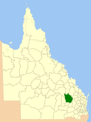
The Shire of Taroom was a local government area in the Darling Downs region of Queensland, Australia, along the Leichhardt Highway to the north of Miles. The shire covered an area of 18,644.5 square kilometres (7,198.7 sq mi), and existed as a local government area from 1879 until 2008, when it was dissolved and split between the new Western Downs Region and the Shire of Banana.

The Hornet Bank massacre was the killing of eleven British settlers, which included eight members of the Fraser family, by a group of mostly Yiman Indigenous Australians. The massacre occurred at about one or two o'clock in the morning of 27 October 1857 at Hornet Bank station on the upper Dawson River near Eurombah in central Queensland, Australia. It has been moderately estimated that 150 Aboriginal people succumbed in subsequent punitive expeditions conducted by Native Police, private settler militias, and by William Fraser in or around Eurombah district. Indiscriminate shootings of "over 300" Aboriginal men, women, and children, however, were reportedly conducted by private punitive expedition some 400 kilometres eastward at various stations in the Wide Bay district alone. The result was the near-extermination of the entire Yiman tribe and language group by 1858; this claim was disputed, however, and descendants of this group have recently been recognised by the High Court of Australia to be the original custodians of the land surrounding the town of Taroom.

<span class="mw-page-title-main">Maranoa River</span> River in Queensland, Australia

The Maranoa River, part of the Murray-Darling basin, is a river situated in South West Queensland, Australia.

<span class="mw-page-title-main">Carnarvon Range</span> Mountain range in Queensland, Australia

The Carnarvon Range is a mountain range in Central Queensland, Australia. It is a plateau section of the Great Dividing Range. The Carnarvon Range is 160 km in length.

<span class="mw-page-title-main">Leichhardt Tree, Taroom</span> Historic site in Queensland, Australia

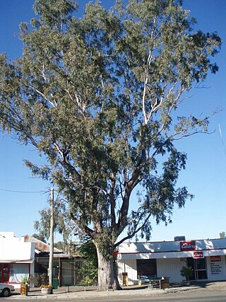
Leichhardt Tree is a heritage-listed blazed tree at Yaldwyn Street, Taroom, Shire of Banana, Queensland, Australia. The blaze was made in 1844 by Ludwig Leichhardt. It was added to the Queensland Heritage Register on 21 October 1992.

<span class="mw-page-title-main">Glebe, Queensland</span> Suburb of Shire of Banana, Queensland, Australia

Glebe is a rural locality in the Shire of Banana, Queensland, Australia. In the 2016 census Glebe had a population of 24 people.

The Yiman, also known as Yeeman, Eoman or Jiman, and by themselves in modern times as Iman, are an Aboriginal Australian people living in the Upper Dawson River region around Taroom of eastern Central Queensland.

<span class="mw-page-title-main">Fitzroy Developmental Road</span>

The Fitzroy Developmental Road is a designated road in the Central Highlands Region of Queensland consisting of three separate sections. The general direction is from south to north.

The Leichhardt Way is an Australian road route from Melbourne, Victoria to Rockhampton in Queensland. It has been designated by the Queensland Government as a State Strategic Touring Route.

Spring Creek is a rural locality in the Shire of Banana, Queensland, Australia. In the 2016 census Spring Creek had a population of 15 people.

Eidsvold–Theodore Road is a continuous 143.7 kilometres (89.3 mi) road route in the North Burnett and Banana regions of Queensland, Australia. The entire route is signed as State Route 73. It is a state-controlled district road rated as a local road of regional significance.

References

  1. 1 2 "Dawson River (entry 9457)". Queensland Place Names. Queensland Government . Retrieved 19 November 2015.
  2. 1 2 "Map of Dawson River, QLD". Bonzle Digital Atlas of Australia. Archived from the original on 23 September 2015. Retrieved 19 November 2015.
  3. "Dawson River – watercourse in Central Highlands Region (entry 9457)". Queensland Place Names. Queensland Government . Retrieved 6 May 2019.
  4. "Dawson River". Department of Environment and Resource Management. 28 September 2009. Archived from the original on 11 August 2011. Retrieved 27 September 2011.
  5. Barrett, Roseanne (8 January 2011). "Returning home to mud and memories lost". The Australian . News Limited. Retrieved 27 September 2011.
  6. CC BY icon-80x15.png This Wikipedia article incorporates CC-BY-4.0 licensed text from: "Yiman". Queensland Aboriginal and Torres Strait Islander languages map. State Library of Queensland . Retrieved 23 January 2024.
  7. 1 2 3 4 Katter, Bob (2012). An Incredible Race of People: A Passionate History of Australia. Millers Point, New South Wales: Murdoch Books Australia. p. 52.