Gregory River (Australia)

Last updated

Gregory
Gregory River, North West Queensland.jpg
Gregory River, North West Queensland
Australia Queensland relief location map.jpg
Red pog.svg
Location of Gregory River mouth in Queensland
EtymologyIn honour of Augustus Gregory
Native nameNgumarryina (Wanyi)
Location
Country Australia
Territory and State Northern Territory, Queensland
Physical characteristics
Source Barkly Tableland
  location Northern Territory
  elevation263 m (863 ft)
Mouth Nicholson River
  location
southwest of Burketown, Queensland
  coordinates
17°53′52″S139°17′06″E / 17.89778°S 139.28500°E / -17.89778; 139.28500
  elevation
11 m (36 ft)
Length321 km (199 mi)
Basin size24,179 km2 (9,336 sq mi)
Basin features
River system Nicholson River catchment
[1]

The Gregory River (Waanyi: Ngumarryina) is a river in the Northern Territory and the state of Queensland, Australia. The river is the largest perennial river in arid and semi-arid Queensland, [2] [3] one of the few permanently flowing rivers in the northwest of Queensland.

Contents

Course and features

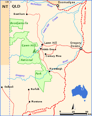
The headwaters of the river rise on the north-eastern section of the Barkly Tableland [4] in the Northern Territory, in an area of gently undulating downs country dominated by cattle stations. The river is fed by springs in shallow valleys [5] and it then flows eastwards through an area of well-developed canyons in Queensland. The river is joined by one of its major tributaries, the O'Shanassy River, a little downstream of Riversleigh. [6] Another main tributary Lawn Hill Creek discharges into the Gregory further downstream of Gregory Downs. The Gregory discharges into the Nicholson River to the southwest of Burketown, having descended 252 metres (827 ft) over its 321-kilometre (199 mi) course. [1]

The river has a catchment area of approximately 24,179 square kilometres (9,336 sq mi) and is part of the 52,234 square kilometres (20,168 sq mi) Nicholson River catchment. [2] The area on the Barkly Tableland is made up of dissected limestone-dolomite slopes, canyons and plateaus. [2]

The river has a mean annual flow of 694 gigalitres (1.53×10¹¹ imp gal; 1.83×10¹¹ US gal) with a minimum flow of 123 GL (2.7×10¹⁰ imp gal; 3.2×10¹⁰ US gal) recorded in 1984–85 and a maximum flow of 3,701 GL (8.14×10¹¹ imp gal; 9.78×10¹¹ US gal) recorded in 1973–74. [2] A number of wetlands of national significance are found within the catchment. These include the 26,639-hectare (65,826-acre) Gregory River wetland and the 298,888-hectare (738,568-acre) Thorntonia Aggregation. [2]

In March 2023, over 500 mm of rain fell across an already wet catchment in 48 hours, leading to record flooding. The Gregory River at Riversleigh, near Lawn Hill, reached a height of 18 metres (59 ft), surpassing the 1971 flood record of 10.8 metres (35 ft) by a large margin. [7]

The river is surrounded by forested areas on the upper reaches, with riparian woodlands and open savannah on the plains. Grasslands are made up of Astrebla pectinate and Eulalia fulca that grow on the heavy grey pedocals. Fringing forest is made up of a mix of Corymbia papuana , Eucalyptus tectifica and Eucalyptus microtheca . [8]

History

The traditional owners of the river are the Waanyi Aboriginal people, who call the river Ngumarryina. [9]

In 1861, William Landsborough [10] came across it during his 1861 expedition to find the lost Burke and Wills expedition. [11] Landsborough found the river while traveling from Burketown and followed it all the way to the Barkly Tableland. He named it the Gregory River in honour of Augustus Gregory, at the time the Queensland Surveyor General and an explorer.

See also

Related Research Articles

<span class="mw-page-title-main">Boodjamulla National Park</span> Protected area in Queensland, Australia

Boodjamulla National Park, formerly known as Lawn Hill National Park, is a national park in the Shire of Burke, Queensland, Australia. The Riversleigh World Heritage Area is a World Heritage Site within the park.

<span class="mw-page-title-main">Mitchell River (Queensland)</span> River in Queensland, Australia

The Mitchell River is a river in Far North Queensland, Australia. The river rises on the Atherton Tableland about 50 kilometres (31 mi) northwest of Cairns and flows about 750 kilometres (470 mi) northwest across Cape York Peninsula from Mareeba to the Gulf of Carpentaria.

<span class="mw-page-title-main">Flinders River</span> River in Queensland, Australia

The Flinders River is the longest river in Queensland, Australia, at approximately 1,004 kilometres (624 mi). It was named in honour of the explorer Matthew Flinders. The catchment is sparsely populated and mostly undeveloped. The Flinders rises on the western slopes of the Great Dividing Range in North West Queensland and flows generally north-west through the Gulf Country, across a large, flat clay pan, before entering the Gulf of Carpentaria.

<span class="mw-page-title-main">Barkly Tableland</span> Region in the Northern Territory, Australia

The Barkly Tableland is a region in the Central East if the Northern Territory, extending into Western Queensland. The region was named after Sir Henry Barkly. The epithet “Tableland” is inaccurate, since the region is neither elevated relative to adjacent landforms, nor are the boundaries marked by a distinct change in elevation

<span class="mw-page-title-main">William Landsborough</span> Australian explorer and public servant

William Landsborough was an explorer of Australia and notably he was the first explorer to complete a North-to-South crossing of Australia. He was a member of the Queensland Legislative Council.

<span class="mw-page-title-main">Nathaniel Buchanan</span> Australian pioneer pastoralist, drover and explorer

Nathaniel Buchanan was an Australian pioneer pastoralist, drover and explorer.

The Fairbairn Dam is an earth-filled embankment dam across the Nogoa River, located southwest of Emerald in Central Queensland, Australia. Constructed in 1972 for the primary purpose of irrigation, the impoundment created by the dam serves as one of the major potable water supplies for the region and assists with some flood mitigation.

<span class="mw-page-title-main">Gulf Country</span> Queensland region

The Gulf Country or North West Queensland is the region of woodland and savanna grassland surrounding the Gulf of Carpentaria in north western Queensland and eastern Northern Territory on the north coast of Australia. The region is also called the Gulf Savannah. The Gulf Country is crossed by the Savannah Way highway.

<span class="mw-page-title-main">Gregory, Queensland</span> Town in Queensland, Australia

Gregory is an outback town and locality in the Shire of Burke, Queensland, Australia. In the 2016 census, the locality of Gregory had a population of 72 people.

<span class="mw-page-title-main">Jardine River</span> River in Queensland, Australia

The Jardine River, formally known as Deception River, is the largest river of the Cape York Peninsula in Far North Queensland, Australia.

Lake Hindmarsh, an ephemeral lake located in the Wimmera region of western Victoria, Australia, is the state's largest natural freshwater lake. The nearest towns are Jeparit to the south and Rainbow to the north. After more than a decade of drought, in early 2011 the lake filled as a result of flooding in the region. The Wemba Wemba name of the lake is recorded as Gour or Koor.

<span class="mw-page-title-main">Alexandria Station (Northern Territory)</span> Cattle station and pastroal lease in the Northern Territory, Australia

The Settlement Creek is a creek in the Northern Territory and the state of Queensland, Australia.

The Nicholson River is a river in the Northern Territory and the state of Queensland, Australia.

The Holroyd River is a river located on the Cape York Peninsula in Far North Queensland, Australia.

<span class="mw-page-title-main">Bowen River (Queensland)</span> River in Queensland, Australia

The Bowen River is a river in North Queensland, Australia.

<span class="mw-page-title-main">Tree of Knowledge, Camooweal</span> Historic site in Queensland, Australia

Tree of Knowledge is a heritage-listed tree on the Barkly Highway, Camooweal, City of Mount Isa, Queensland, Australia. It was added to the Queensland Heritage Register on 8 September 2005.

<span class="mw-page-title-main">Landsborough's Blazed Tree (Camp 67)</span> Heritage-listed tree in Queensland, Australia

Landsborough's Blazed Tree is a heritage-listed tree at Mitchell Highway, Charleville, Shire of Murweh, Queensland, Australia. It was marked by William Landsborough. It was added to the Queensland Heritage Register on 18 June 2009.

The Nguburinji people, also written Ngoborindi, Oborindi and other variations, are an Aboriginal Australian people whose traditional lands lie in northwest Queensland.

The Waanyi people, also spelt Wanyi, Wanji, or Waanji, are an Aboriginal Australian people from south of the Gulf of Carpentaria in Queensland and the Northern Territory.

References

  1. 1 2 "Map of Gregory River". Bonzle Digital Atlas of Australia. Archived from the original on 24 May 2018. Retrieved 2 June 2015.
  2. 1 2 3 4 5 "Ecological Assessment of the Freshwater Wetlands in the Nicholson-Gregory Catchment, North-Western Queensland" (PDF). James Cook University. 1 July 2005. Archived (PDF) from the original on 21 July 2015. Retrieved 2 June 2015.
  3. "Gregory Downs". Queensland Government. Archived from the original on 4 June 2015. Retrieved 4 June 2015.
  4. Randal, M. A. (1967). "Groundwater in the Barkly Tableland, N.T." (PDF). Commonwealth of Australia. Archived (PDF) from the original on 22 December 2015. Retrieved 3 June 2015.
  5. "Barkly Tableland". Queensland Places. Archived from the original on 5 June 2015. Retrieved 4 June 2015.
  6. "Flood warning on the Nicholson River". Bureau of Meteorology. Archived from the original on 5 June 2015. Retrieved 4 June 2015.
  7. https://www.abc.net.au/news/2023-03-09/evacuations-amid-unprecedented-gulf-flooding/102074770%7CRetrieved 10 March 2023
  8. Christian, Noakes; et al. (1947). "Survey of the Barkly Region, Northern Territory and Queensland" (PDF). CSIRO. Archived (PDF) from the original on 22 December 2015. Retrieved 4 June 2015.
  9. Scambary, Benedict (2013). My Country, Mine Country: Indigenous People, Mining and Development Contestation in Remote Australia. ANU E Press.
  10. "Landsborough's Blazed Tree, Camp 69 (entry 602715)". Queensland Heritage Register . Queensland Heritage Council. Retrieved 15 August 2015.
  11. Trundle, Gwen (1974). "Landsborough, William (1825–1886)". Australian Dictionary of Biography . Australian National University. Archived from the original on 11 April 2015.